

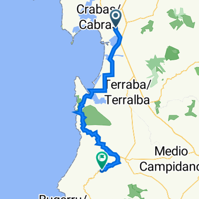
Sard 06. Oristano to Arbus
Trasa rowerowa rozpoczynająca się w Oristano, Sardegna, Włochy.
Przegląd
O tej trasie
- -:--
- Czas
- 80 km
- Dystans
- 1264 m
- Przewyższenia
- 880 m
- Spadek
- ---
- Śr. Prędkość
- 462 m
- Maks. wysokość

Jakość trasy
Typy dróg i nawierzchnie na trasie
Typy dróg
Droga
40,8 km
(51 %)
Spokojna droga
10,4 km
(13 %)
Powierzchnie
Utwardzona
31,2 km
(39 %)
Nieutwardzona
4 km
(5 %)
Asfalt
30,4 km
(38 %)
Nieutwardzony (nieokreślony)
1,6 km
(2 %)
Najważniejsze punkty trasy
Punkty zainteresowania na trasie
Nocleg po 0 km
Il giardino di Don Peppino
Woda pitna po 0,7 km
La Dolce Vita breakfast - opens 0700
Interesujące miejsce po 2,7 km
Basilica di Santa Giusta
Interesujące miejsce po 4,3 km
Ponte Romano
Interesujące miejsce po 9,9 km
S'ena Arrubia flamingos, herons etc
Woda pitna po 16 km
Emmetrelle Di Pau Giuseppe & C. Snc Supermarket
Interesujące miejsce po 27,6 km
Torre Vecchia di Marceddì
Interesujące miejsce po 28,8 km
Chiesa della Madonna di Bonaria
Interesujące miejsce po 28,8 km
Chiesa della Madonna di Bonaria
Woda pitna po 31,5 km
Dedoni Formaggi Sardi Artigianali cheese maker opens 0830
Woda pitna po 31,5 km
L'unione Sarda Cafe opens 0700
Interesujące miejsce po 53,6 km
Monte Arcuentu volcano
Interesujące miejsce po 62,1 km
Ex Ospedale Montevecchio
Interesujące miejsce po 62,5 km
Ex Albergo "Al cinghiale"
Interesujące miejsce po 62,6 km
Miniera di Montevecchio the mining area of Montevecchio, a UNESCO world heritage site, outlines the vibrant mining activity carried out from 1848 until 1991. In a historical-cultural tour (ca. 90-120mins) you can discover simple workers' housing, impressive management building as well as processing sites. At its peak the mines were the largest in Italy and employed about 4000 people. PS: the roof and spire of the Notre-Dame cathedral in Paris were covered with 460 tons of lead tiles (until destroyed by the tragic fire in April 2019) which were produced in the Montevecchio mines. The ticket office is in the upper part of the hill.Tours may be Sat/Sun only.
Interesujące miejsce po 64,3 km
Pozzo Sant'Antonio Museum
Interesujące miejsce po 64,4 km
Galleria Anglosarda Mineshaft / Museum
Interesujące miejsce po 65,9 km
CEAS - Centro di Educazione all'Ambiente e alla Sostenibilità
Interesujące miejsce po 68,2 km
Birrificio 4 Mori Excellent Brewery open 0900 - 1500 The guided tasting of the beers paired with typical local products costs 20 euros per person.
Interesujące miejsce po 70,1 km
Nuraghe Genna Maria The nuraghe Genna Maria is an archaeological site in the comune of Villanovaforru, province of South Sardinia. It is located atop a hill in the Marmilla region, in the province of Sud Sardegna in Sardinia. The structure is complex, formed by an original central tower, built in the middle Bronze Age (2200-1600 BC), to which later were added other four towers and a bastion. One of the four towers was subsequently sacrificed during a further intervention, that also saw, presumably, the edification of the mighty external wall of hexagonal shape.[1] In the early Iron Age in the site developed a new village.[1] The Nuraghic complex Entrance to the tower The Nuragic complex originally consisted of the central Nuraghe (Mastio) tomb, which was built about 1350 BC, as well as three tombs which were established about 1000 BC. This complex was later surrounded by outer walls. The outer wall spans a wide courtyard in a stretched hexagonal shape. The interest of archaeologists is primarily focused on this village. It dates back to the Iron Age around 800 BC. This period is called the "geometric epoch" because of the characteristic decorations on the ceramics. A parallel development is represented by the geometric-ceramic epoch in Greece (900-700 BC). According to sources, contacts with Greece were established during the Mycenaean period.[2] The complex was damaged by fire and abandoned in the 8th century BC. Later, in the 5th or 4th century BC, at the time of the Punic occupation of parts of Sardinia, people again came to the Nuraghe Genna Maria. The Sardinian-Punic population set up a small sanctuary in the buried Nuraghes. The preserved wall remains of the Nuraghes, which were already repaired several times in ancient times, are a maximum of three meters high.[2] Discovery During the archaeological excavations of the poorly preserved Nuraghic, which began in 1977 and lasted for 30 years, there were valuable materials found in the area. Ceramics, grinding stones, plant remains were excavated and researched by the Chair of Genetics of the University of Cagliari. The finds are exhibited in a museum named after the complex in the center of Villanovaforru
Nocleg po 80 km
S’Ena Hotel Ristorante
Kontynuuj z Bikemap
Użyj, edytuj lub pobierz tę trasę rowerową
Chcesz przejechać trasę Sard 06. Oristano to Arbus lub dostosować ją do swojej wycieczki? Oto, co możesz zrobić z tą trasą na Bikemap:
Darmowe funkcje
- Zapisz tę trasę jako ulubioną lub w kolekcji
- Skopiuj i zaplanuj swoją wersję tej trasy
- Podziel trasę na etapy, aby utworzyć kilkudniową wycieczkę
- Synchronizuj swoją trasę z Garminem lub Wahoo
Funkcje Premium
3 dni bezpłatnej wersji próbnej lub jednorazowa opłata. Dowiedz się więcej o Bikemap Premium.
- Nawiguj po tej trasie na iOS i Androidzie
- Eksportuj plik GPX / KML tej trasy
- Stwórz swój własny wydruk (wypróbuj za darmo)
- Pobierz tę trasę do nawigacji offline
Odkryj więcej funkcji Premium.
Uzyskaj Bikemap PremiumOd naszej społeczności
Oristano: Inne popularne trasy rozpoczynające się tutaj
 Sard 06. Oristano to Arbus
- Dystans
- 80 km
- Przewyższenia
- 1264 m
- Spadek
- 880 m
- Lokalizacja
- Oristano, Sardegna, Włochy
 IT Sardinia 46.0 - Oristano to Barumini
- Dystans
- 78,5 km
- Przewyższenia
- 822 m
- Spadek
- 603 m
- Lokalizacja
- Oristano, Sardegna, Włochy
 5.Oristano-S'Archittu
- Dystans
- 66,8 km
- Przewyższenia
- 178 m
- Spadek
- 173 m
- Lokalizacja
- Oristano, Sardegna, Włochy
 47/377: Santa Giusta
- Dystans
- 4,6 km
- Przewyższenia
- 9 m
- Spadek
- 13 m
- Lokalizacja
- Oristano, Sardegna, Włochy
 visit Mom
- Dystans
- 74,4 km
- Przewyższenia
- 602 m
- Spadek
- 582 m
- Lokalizacja
- Oristano, Sardegna, Włochy
 Oristano_Pistis
- Dystans
- 45 km
- Przewyższenia
- 134 m
- Spadek
- 109 m
- Lokalizacja
- Oristano, Sardegna, Włochy
 Sardinien
- Dystans
- 620,8 km
- Przewyższenia
- 2079 m
- Spadek
- 2091 m
- Lokalizacja
- Oristano, Sardegna, Włochy
 sinis
sinis- Dystans
- 19,7 km
- Przewyższenia
- 22 m
- Spadek
- 35 m
- Lokalizacja
- Oristano, Sardegna, Włochy
Otwórz ją w aplikacji