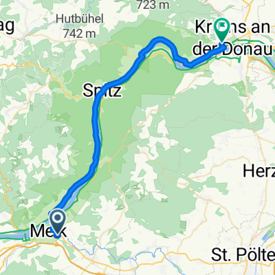
Wachau: Melk - Krems
Trasa rowerowa rozpoczynająca się w Melk, Dolna Austria, Austria.
Przegląd
O tej trasie
- -:--
- Czas
- 38,5 km
- Dystans
- 241 m
- Przewyższenia
- 268 m
- Spadek
- ---
- Śr. Prędkość
- 263 m
- Maks. wysokość
Jakość trasy
Typy dróg i nawierzchnie na trasie
Typy dróg
Droga rowerowa
15,8 km
(41 %)
Droga
10,4 km
(27 %)
Powierzchnie
Utwardzona
36,9 km
(96 %)
Asfalt
36,2 km
(94 %)
Beton
0,8 km
(2 %)
Niezdefiniowany
1,5 km
(4 %)
Najważniejsze punkty trasy
Punkty zainteresowania na trasie

Interesujące miejsce po 13,1 km
Ruins of Aggstein castle. Very steep ascend! Beautiful views, restaurant. Admission costs 12-15EUR

Interesujące miejsce po 17,4 km
Ruins of Hinterhaus castle. Admission is free. Nice views on Wachau valley.
Interesujące miejsce po 18,3 km
Ferry to the other side of Danube. Costs 3-4 EUR for the person with bicycle.

Interesujące miejsce po 20,6 km
Defensive church with Napoleonic wars artillery tower.

Interesujące miejsce po 22,1 km
Small characteristic medieval town. Worth walking through.
Interesujące miejsce po 24,4 km
Ferry to the other side of Danube. Costs 3-4 EUR for the person with bicycle.
Interesujące miejsce po 24,5 km
Old magistrate with nice internal court.

Interesujące miejsce po 24,5 km
Old defensive church. The town itself was grounded before Austria (first mentioning in 994 A.D.)

Interesujące miejsce po 29,8 km
Ruins of castle Dürnstein from XII century. Magnificent views on Wachau valley. King Richard the Lionheart for one year before England gathered ransom for him.

Interesujące miejsce po 30,2 km
Nice medieval city. A bit touristic but has a lot of restaurants that offer local food and wine.
Interesujące miejsce po 36,3 km
Old part of the city. Medieval building in which people still live and do their normal business stuff.
Kontynuuj z Bikemap
Użyj, edytuj lub pobierz tę trasę rowerową
Chcesz przejechać trasę Wachau: Melk - Krems lub dostosować ją do swojej wycieczki? Oto, co możesz zrobić z tą trasą na Bikemap:
Darmowe funkcje
- Zapisz tę trasę jako ulubioną lub w kolekcji
- Skopiuj i zaplanuj swoją wersję tej trasy
- Synchronizuj swoją trasę z Garminem lub Wahoo
Funkcje Premium
3 dni bezpłatnej wersji próbnej lub jednorazowa opłata. Dowiedz się więcej o Bikemap Premium.
- Nawiguj po tej trasie na iOS i Androidzie
- Eksportuj plik GPX / KML tej trasy
- Stwórz swój własny wydruk (wypróbuj za darmo)
- Pobierz tę trasę do nawigacji offline
Odkryj więcej funkcji Premium.
Uzyskaj Bikemap PremiumOd naszej społeczności
Melk: Inne popularne trasy rozpoczynające się tutaj
 Rathausplatz, Melk nach Bahnhofplatz, Krems an der Donau
- Dystans
- 37,8 km
- Przewyższenia
- 213 m
- Spadek
- 237 m
- Lokalizacja
- Melk, Dolna Austria, Austria
 Melk a Wiener Straße, Tulln an der Donau
- Dystans
- 81,1 km
- Przewyższenia
- 290 m
- Spadek
- 358 m
- Lokalizacja
- Melk, Dolna Austria, Austria
 Frainingau, Zelking-Matzleinsdorf to 3, Leiben
- Dystans
- 11,4 km
- Przewyższenia
- 36 m
- Spadek
- 39 m
- Lokalizacja
- Melk, Dolna Austria, Austria
 02 Melk - Linz
- Dystans
- 105 km
- Przewyższenia
- 470 m
- Spadek
- 426 m
- Lokalizacja
- Melk, Dolna Austria, Austria
 Melk - Linz
- Dystans
- 104,6 km
- Przewyższenia
- 468 m
- Spadek
- 422 m
- Lokalizacja
- Melk, Dolna Austria, Austria
 Grafenegg - Wien
- Dystans
- 122,5 km
- Przewyższenia
- 549 m
- Spadek
- 568 m
- Lokalizacja
- Melk, Dolna Austria, Austria
 <Tour 3 -Von Melk bis Klosterneuburg -107.2 km , + 904 hm - 931 hm
- Dystans
- 107,2 km
- Przewyższenia
- 904 m
- Spadek
- 931 m
- Lokalizacja
- Melk, Dolna Austria, Austria
 Von Melk bis Krems an der Donau
- Dystans
- 38,1 km
- Przewyższenia
- 184 m
- Spadek
- 236 m
- Lokalizacja
- Melk, Dolna Austria, Austria
Otwórz ją w aplikacji


