

Ride Day 16—26 Sept 2005—11500 Quillan - Circle
Trasa rowerowa rozpoczynająca się w Quillan, Occitanie, Francja.
Przegląd
O tej trasie
Ponieważ zdecydowaliśmy się zostać w Quillan przez dwie noce i mieliśmy nadzieję, że pogoda się poprawi, wyruszyliśmy w tę okrężną trasę pod groźnym niebem i na szczęście bez sakw.
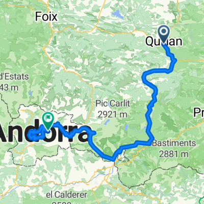
Dzień okazał się wspaniały, a wybór dróg przez moją żonę był niezwykły. D117, mimo że miała zbyt dużo ruchu, przebiegała przez piękną wąwóz o nazwie Défilé de Pierre-Lys. D107 wznosiła się na przeważnie łagodnych nachyleniach wzdłuż bardzo ładnego strumienia i niemal nie miała ruchu. Krajobrazy i widoki, gdy powoli wspinaliśmy się na Plateau de Sault, były również znakomite. I naprawdę istniała płaska przestrzeń, która uzasadniała nazywanie tego płaskowyżem. Powrót z naszego najwyższego punktu 896 m wzdłuż D613 i D117 oferował wiele spektakularnych widoków na dolinę Quillan i otaczające ją góry. Zjazd wzdłuż D117, który zrobiliśmy w stosunkowo ciemnych i deszczowych warunkach wczoraj, dzisiaj był prawdziwą przyjemnością.
Tło:
Moja żona i ja od 1993 roku robimy wycieczki z samodzielnym wsparciem w Europie Zachodniej (w większości we Francji). Ta seria jazd obejmuje naszą trzymiesięczną trasę przez część Francji z 2005 roku. Naszym punktem początku i zakończenia jest w pobliżu Chaduri (na południe od Angoulême), gdzie nasi przyjaciele mają farmę z Gites i Chambres d'Hotes.
Jeździliśmy naszymi rowerami turystycznymi Dawes kupionymi w 1993 roku, mocno obciążonymi oponami 700Cx32. Cała nasza jazda odbywała się po asfaltowych drogach, głównie z bardzo małym ruchem.
Jeśli masz jakieś pytania, śmiało pisz na adres e-mail jeffkadet@netdiving.com.
Jeff.
- -:--
- Czas
- 60,1 km
- Dystans
- 747 m
- Przewyższenia
- 748 m
- Spadek
- ---
- Śr. Prędkość
- ---
- Maks. wysokość

Kontynuuj z Bikemap
Użyj, edytuj lub pobierz tę trasę rowerową
Chcesz przejechać trasę Ride Day 16—26 Sept 2005—11500 Quillan - Circle lub dostosować ją do swojej wycieczki? Oto, co możesz zrobić z tą trasą na Bikemap:
Darmowe funkcje
- Zapisz tę trasę jako ulubioną lub w kolekcji
- Skopiuj i zaplanuj swoją wersję tej trasy
- Synchronizuj swoją trasę z Garminem lub Wahoo
Funkcje Premium
3 dni bezpłatnej wersji próbnej lub jednorazowa opłata. Dowiedz się więcej o Bikemap Premium.
- Nawiguj po tej trasie na iOS i Androidzie
- Eksportuj plik GPX / KML tej trasy
- Stwórz swój własny wydruk (wypróbuj za darmo)
- Pobierz tę trasę do nawigacji offline
Odkryj więcej funkcji Premium.
Uzyskaj Bikemap PremiumOd naszej społeczności
Quillan: Inne popularne trasy rozpoczynające się tutaj
 2009 Entre-deux-mers - 2
- Dystans
- 259,7 km
- Przewyższenia
- 79 m
- Spadek
- 328 m
- Lokalizacja
- Quillan, Occitanie, Francja
 Belvédère du Diable
- Dystans
- 7 km
- Przewyższenia
- 442 m
- Spadek
- 441 m
- Lokalizacja
- Quillan, Occitanie, Francja
 Quillan - Grandvalira Sector Carrillo
- Dystans
- 191,1 km
- Przewyższenia
- 4499 m
- Spadek
- 2756 m
- Lokalizacja
- Quillan, Occitanie, Francja
 Ride Day 17—27 Sept 2005—11500 Quillan to 11350 Cucugnan
- Dystans
- 66,6 km
- Przewyższenia
- 778 m
- Spadek
- 790 m
- Lokalizacja
- Quillan, Occitanie, Francja
 VTT Pyrénées - circuit n°22
- Dystans
- 29,8 km
- Przewyższenia
- 584 m
- Spadek
- 584 m
- Lokalizacja
- Quillan, Occitanie, Francja
 Ride Day 16—26 Sept 2005—11500 Quillan - Circle
- Dystans
- 60,1 km
- Przewyższenia
- 747 m
- Spadek
- 748 m
- Lokalizacja
- Quillan, Occitanie, Francja
 etapa 2 - R
- Dystans
- 142,7 km
- Przewyższenia
- 2047 m
- Spadek
- 1940 m
- Lokalizacja
- Quillan, Occitanie, Francja
 Col de Jau
- Dystans
- 100,8 km
- Przewyższenia
- 2279 m
- Spadek
- 2279 m
- Lokalizacja
- Quillan, Occitanie, Francja
Otwórz ją w aplikacji