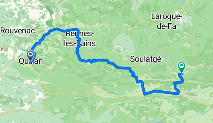

Quillan - Ax-les-Thermes
- 79,8 km
- 834 m
- 892 m
- Quillan, Occitanie, Francja
Trasa rowerowa rozpoczynająca się w Quillan, Occitanie, Francja.
Przegląd
Z wyjątkiem dwóch głównych dróg (D118 i D117), dzisiejsza jazda była naprawdę wyjątkowa.
Droga D14 wspinała się przez piękny obszar, który stał się nieco suchy przy Pic de Bugarach, który jest oszałamiającym widokiem z każdego kąta. Pic de Bugarach ma wysokość 1230 m, a my minęliśmy go na Col du Linas na wysokości 680 m. W tym roku jechaliśmy z zachodu na wschód. Cztery lata temu jechaliśmy tą drogą ze wschodu na zachód.
Drogi D10/D17 prowadziły nas przez piękny wąwóz z wąską drogą wykutą w zboczach. Niewiarygodna droga i cudowne widoki. Podczas jazdy tą drogą przez następne kilka godzin przebywaliśmy w departamencie Pyrénées-Orientales, zanim wróciliśmy do Aude trasą D19/D123. Ta ostatnia droga z Maury do Cucugnan była pięknym podjazdem nad doliną otoczoną górami. Ten podjazd zaprowadził nas do Grau de Maury na wysokości 432 m, gdzie jest droga prowadząca dalej do Château de Quéribus. Z Grau de Maury zjechaliśmy bezpośrednio do Cucugnan, które znajduje się na małym wzgórzu w kolejnej ogromnej dolinie otoczonej górami. Podobnie jak dolina Maury, jest tam wiele winnic.
Tło:
Moja żona i ja od 1993 roku jeździmy na samodzielne wycieczki po Europie Zachodniej (głównie we Francji). Ta seria przejażdżek obejmuje naszą trasę z 2005 roku trwającą 2 miesiące przez różne części Francji. Nasz punkt startowy i końcowy znajduje się w pobliżu Chaduri (na południe od Angoulême), gdzie nasi przyjaciele mają farmę z Gîtes i Chambres d'Hôtes.
Jeździliśmy na naszych rowerach turystycznych Dawes, zakupionych w 1993 roku, mocno obciążonych oponami 700Cx32. Wszystkie nasze przejazdy odbywały się po drogach asfaltowanych, głównie z bardzo małym ruchem.
W razie pytań proszę o kontakt mailowy: jeffkadet@netdiving.com
Jeff
utworzono 14 lat temu temu
Kontynuuj z Bikemap
Chcesz przejechać trasę Ride Day 17—27 Sept 2005—11500 Quillan to 11350 Cucugnan lub dostosować ją do swojej wycieczki? Oto, co możesz zrobić z tą trasą na Bikemap:
3 dni bezpłatnej wersji próbnej lub jednorazowa opłata. Dowiedz się więcej o Bikemap Premium.
Odkryj więcej funkcji Premium.
Uzyskaj Bikemap PremiumOd naszej społeczności
Otwórz ją w aplikacji