

Ride Day 31—12 Oct 2005—48210 St-Chely du Tarn/Sainte Énimie to 48260 Recoules D'Aubrac (Nasbinals)
Trasa rowerowa rozpoczynająca się w Chanac, Occitanie, Francja.
Przegląd
O tej trasie
To była kolejna jazda pod groźnymi chmurami przez cały dzień... i znów mieliśmy szczęście, że nie zostaliśmy przemoczeni. Jedynymi niedogodnościami były zimny wiatr i mgła na wyższych wysokościach, gdy dotarliśmy w góry Aubrac pod koniec jazdy. Tam znajdowaliśmy się generalnie między 1200 M a 1250 M, z maksymalnym pułapem 1280 M. Nasz cieplejszy strój rowerowy działał wspaniale. Kraj wokół, jednak, był świetny do jazdy na rowerze; to była prawdziwa przyjemność być tam. Wzdłuż N9 zobaczyliśmy budowę nowego mostu, który przypomniał nam wiadukt, który minęliśmy w zeszłym roku w 2004, tuż na zachód od Millau. Część tego nowego mostu zdawała się wisieć bez jakiegokolwiek wsparcia. Tablica informowała, że okres budowy trwał od 2003 do 2007. [W 2009 roku, a być może także w innych latach, znów przejeżdżaliśmy tędy, znajdując most ukończony.] Przejeżdżając przez Marvejols, natknęliśmy się na rzeźbę potwora z Marvejols. Zdecydowanie dobre miejsce na zdjęcie. Tło: Moja żona i ja od 1993 roku robimy wycieczki z własnym wsparciem w Europie Zachodniej (głównie we Francji). Ta seria jazd pokrywa naszą dwumiesięczną trasę z 2005 roku przez części Francji. Nasz punkt początkowy i końcowy znajduje się w pobliżu Chaduri (na południe od Angoulême), gdzie nasi przyjaciele mają farmę z Gites i Chambres d'Hotes. Jeździliśmy na naszych rowerach turystycznych Dawes kupionych w 1993 roku, mocno załadowanych oponami 700Cx32. Cała nasza jazda odbywała się po drogach utwardzonych, głównie z bardzo małym ruchem. W przypadku pytań, proszę śmiało pisać na adres jeffkadet@netdiving.com. Jeff
- -:--
- Czas
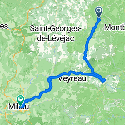
- 86,1 km
- Dystans
- 1224 m
- Przewyższenia
- 644 m
- Spadek
- ---
- Śr. Prędkość
- ---
- Maks. wysokość

Jakość trasy
Typy dróg i nawierzchnie na trasie
Typy dróg
Spokojna droga
3,4 km
(4 %)
Droga dojazdowa
0,9 km
(1 %)
Powierzchnie
Utwardzona
61,1 km
(71 %)
Nieutwardzona
0,9 km
(1 %)
Asfalt
61,1 km
(71 %)
Żwir
0,9 km
(1 %)
Niezdefiniowany
24,1 km
(28 %)
Kontynuuj z Bikemap
Użyj, edytuj lub pobierz tę trasę rowerową
Chcesz przejechać trasę Ride Day 31—12 Oct 2005—48210 St-Chely du Tarn/Sainte Énimie to 48260 Recoules D'Aubrac (Nasbinals) lub dostosować ją do swojej wycieczki? Oto, co możesz zrobić z tą trasą na Bikemap:
Darmowe funkcje
- Zapisz tę trasę jako ulubioną lub w kolekcji
- Skopiuj i zaplanuj swoją wersję tej trasy
- Podziel trasę na etapy, aby utworzyć kilkudniową wycieczkę
- Synchronizuj swoją trasę z Garminem lub Wahoo
Funkcje Premium
3 dni bezpłatnej wersji próbnej lub jednorazowa opłata. Dowiedz się więcej o Bikemap Premium.
- Nawiguj po tej trasie na iOS i Androidzie
- Eksportuj plik GPX / KML tej trasy
- Stwórz swój własny wydruk (wypróbuj za darmo)
- Pobierz tę trasę do nawigacji offline
Odkryj więcej funkcji Premium.
Uzyskaj Bikemap PremiumOd naszej społeczności
Chanac: Inne popularne trasy rozpoczynające się tutaj
 Ste. Enimie - Millau (Causse Route nr. 159)
- Dystans
- 76,7 km
- Przewyższenia
- 1119 m
- Spadek
- 1262 m
- Lokalizacja
- Chanac, Occitanie, Francja
 F124-2024-Chanac-Einrollen-Trekking
- Dystans
- 58,7 km
- Przewyższenia
- 1670 m
- Spadek
- 1670 m
- Lokalizacja
- Chanac, Occitanie, Francja
 F123-2024-Chanac-Correjac-Le Balmes-Chanac
- Dystans
- 42,9 km
- Przewyższenia
- 1243 m
- Spadek
- 1244 m
- Lokalizacja
- Chanac, Occitanie, Francja
 Tarnroute (Nr. 160) Ste. Enemie- Millau
- Dystans
- 55,4 km
- Przewyższenia
- 318 m
- Spadek
- 436 m
- Lokalizacja
- Chanac, Occitanie, Francja
 Ride Day 31—12 Oct 2005—48210 St-Chely du Tarn/Sainte Énimie to 48260 Recoules D'Aubrac (Nasbinals)
- Dystans
- 86,1 km
- Przewyższenia
- 1224 m
- Spadek
- 644 m
- Lokalizacja
- Chanac, Occitanie, Francja
 1999 Radlour am Tarn
- Dystans
- 90,3 km
- Przewyższenia
- 1143 m
- Spadek
- 1115 m
- Lokalizacja
- Chanac, Occitanie, Francja
 Ride Day 30—11 Oct 2005—48210 St-Chely du Tarn/Sainte Énimie — Circle
- Dystans
- 58 km
- Przewyższenia
- 951 m
- Spadek
- 951 m
- Lokalizacja
- Chanac, Occitanie, Francja
 F122-2024-Chanac-Florac-Les Vignes-La Malene-Chanac
- Dystans
- 118,7 km
- Przewyższenia
- 3462 m
- Spadek
- 3474 m
- Lokalizacja
- Chanac, Occitanie, Francja
Otwórz ją w aplikacji