

NHS 75 Anniversary Ride
Trasa rowerowa rozpoczynająca się w City of London, Anglia, Zjednoczone Królestwo Wielkiej Brytanii.
Przegląd
O tej trasie
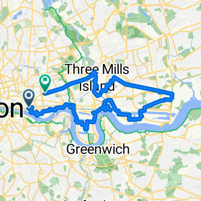
Southwark Cyclists Route: Start/Finish London Bridge - Lloyd George Statue - Aneurin Bevan - Bermondsey Health Centre - Salter Statues.
- 1 h 19 min
- Czas
- 20,8 km
- Dystans
- 84 m
- Przewyższenia
- 83 m
- Spadek
- 15,9 km/h
- Śr. Prędkość
- 29 m
- Maks. wysokość
Jakość trasy
Typy dróg i nawierzchnie na trasie
Typy dróg
Droga rowerowa
11,1 km
(53 %)
Spokojna droga
5,4 km
(26 %)
Powierzchnie
Utwardzona
19,6 km
(94 %)
Asfalt
18,9 km
(91 %)
Kostka brukowa
0,7 km
(3 %)
Niezdefiniowany
1,2 km
(6 %)
Najważniejsze punkty trasy
Punkty zainteresowania na trasie
Interesujące miejsce po 3,1 km
British Medical Association - BMA House First supported, then strongly opposed, formation of NHS. Tavistock Square. (Not on this route).
Interesujące miejsce po 4,1 km
Lloyd George Statue Lloyd George's Liberal government introduced National Insurance in 1911. Included health care for contributors but not dependents.
Interesujące miejsce po 6,8 km
William Beveridge Plaque 1942 Beveridge Report set out plans for social security reforms, including a free health service. (Not on this route)
Interesujące miejsce po 7,9 km
Aneurin Bevan and Jennie Lee blue plaque Noted for tenure as Minister of Health in Clement Attlee's government in which he spearheaded the creation of the British National Health Service.
Interesujące miejsce po 16,2 km
Bermondsey Health Centre Built 1937. First loacal authority health centre. Focus on pubic health. By 1930s local authorities were providing a lot of free health care. Building still in use by NHS. Brief history at https://ezitis.myzen.co.uk/bermondseyhc.html
Interesujące miejsce po 18,3 km
Salter Statues Alfred Salter was a GP in Bermondsey from 1900. He was a passionate social reformer and provided free care to those who could not afford it. Became Bernondsey's MP for 1922-3 and 1929-1945.
Kontynuuj z Bikemap
Użyj, edytuj lub pobierz tę trasę rowerową
Chcesz przejechać trasę NHS 75 Anniversary Ride lub dostosować ją do swojej wycieczki? Oto, co możesz zrobić z tą trasą na Bikemap:
Darmowe funkcje
- Zapisz tę trasę jako ulubioną lub w kolekcji
- Skopiuj i zaplanuj swoją wersję tej trasy
- Synchronizuj swoją trasę z Garminem lub Wahoo
Funkcje Premium
3 dni bezpłatnej wersji próbnej lub jednorazowa opłata. Dowiedz się więcej o Bikemap Premium.
- Nawiguj po tej trasie na iOS i Androidzie
- Eksportuj plik GPX / KML tej trasy
- Stwórz swój własny wydruk (wypróbuj za darmo)
- Pobierz tę trasę do nawigacji offline
Odkryj więcej funkcji Premium.
Uzyskaj Bikemap PremiumOd naszej społeczności
City of London: Inne popularne trasy rozpoczynające się tutaj
 Docklands-Beckton 3
- Dystans
- 35,3 km
- Przewyższenia
- 140 m
- Spadek
- 125 m
- Lokalizacja
- City of London, Anglia, Zjednoczone Królestwo Wielkiej Brytanii
 Day 1 - London to Harwich
- Dystans
- 123,7 km
- Przewyższenia
- 348 m
- Spadek
- 336 m
- Lokalizacja
- City of London, Anglia, Zjednoczone Królestwo Wielkiej Brytanii
 Art Nouveau in London
- Dystans
- 23,4 km
- Przewyższenia
- 215 m
- Spadek
- 221 m
- Lokalizacja
- City of London, Anglia, Zjednoczone Królestwo Wielkiej Brytanii
 Docklands-Beckton 4
- Dystans
- 33,9 km
- Przewyższenia
- 104 m
- Spadek
- 104 m
- Lokalizacja
- City of London, Anglia, Zjednoczone Królestwo Wielkiej Brytanii
 London Parks
- Dystans
- 28,4 km
- Przewyższenia
- 252 m
- Spadek
- 252 m
- Lokalizacja
- City of London, Anglia, Zjednoczone Królestwo Wielkiej Brytanii
 Eping forest 50km
- Dystans
- 51,7 km
- Przewyższenia
- 217 m
- Spadek
- 179 m
- Lokalizacja
- City of London, Anglia, Zjednoczone Królestwo Wielkiej Brytanii
 Victorian Gems and Modern Starchitects
- Dystans
- 18 km
- Przewyższenia
- 193 m
- Spadek
- 195 m
- Lokalizacja
- City of London, Anglia, Zjednoczone Królestwo Wielkiej Brytanii
 MA3K - Short South East
- Dystans
- 21,4 km
- Przewyższenia
- 99 m
- Spadek
- 97 m
- Lokalizacja
- City of London, Anglia, Zjednoczone Królestwo Wielkiej Brytanii
Otwórz ją w aplikacji