

Fall Line Trace
Trasa rowerowa rozpoczynająca się w Columbus, Georgia, USA.
Przegląd
O tej trasie
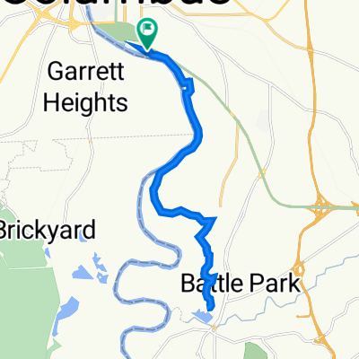
To jest projekt szlaków rowerowych z byłych tras kolejowych. Zaczyna się w pięknych lasach i wychodzi do centrum miasta. Skrzyżowania z drogami są dobrze oznakowane, aż do momentu, gdy zbliżasz się do centrum medycznego. W tym momencie ścieżka przechodzi na drogi i jest oznaczona tylko symbolami rowerów na drodze i kilkoma znakami 'Share the Road'. Na początku dostępny jest parking. Ponieważ kończysz w centrum miasta, możesz zjeść lunch w restauracji, a potem wrócić.
- -:--
- Czas
- 16,6 km
- Dystans
- 77 m
- Przewyższenia
- 147 m
- Spadek
- ---
- Śr. Prędkość
- ---
- Maks. wysokość
Jakość trasy
Typy dróg i nawierzchnie na trasie
Typy dróg
Droga rowerowa
14,8 km
(89 %)
Droga
0,7 km
(4 %)
Powierzchnie
Utwardzona
6 km
(36 %)
Asfalt
4,6 km
(28 %)
Nawierzchnia (nieokreślona)
1,3 km
(8 %)
Niezdefiniowany
10,6 km
(64 %)
Kontynuuj z Bikemap
Użyj, edytuj lub pobierz tę trasę rowerową
Chcesz przejechać trasę Fall Line Trace lub dostosować ją do swojej wycieczki? Oto, co możesz zrobić z tą trasą na Bikemap:
Darmowe funkcje
- Zapisz tę trasę jako ulubioną lub w kolekcji
- Skopiuj i zaplanuj swoją wersję tej trasy
- Synchronizuj swoją trasę z Garminem lub Wahoo
Funkcje Premium
3 dni bezpłatnej wersji próbnej lub jednorazowa opłata. Dowiedz się więcej o Bikemap Premium.
- Nawiguj po tej trasie na iOS i Androidzie
- Eksportuj plik GPX / KML tej trasy
- Stwórz swój własny wydruk (wypróbuj za darmo)
- Pobierz tę trasę do nawigacji offline
Odkryj więcej funkcji Premium.
Uzyskaj Bikemap PremiumOd naszej społeczności
Columbus: Inne popularne trasy rozpoczynające się tutaj
 Pastviny - Columbus
- Dystans
- 22,1 km
- Przewyższenia
- 91 m
- Spadek
- 91 m
- Lokalizacja
- Columbus, Georgia, USA
 1300 Victory Dr, Columbus to 1300 Victory Dr, Columbus
- Dystans
- 16,2 km
- Przewyższenia
- 111 m
- Spadek
- 114 m
- Lokalizacja
- Columbus, Georgia, USA
 Fall Line Trace
- Dystans
- 16,6 km
- Przewyższenia
- 77 m
- Spadek
- 147 m
- Lokalizacja
- Columbus, Georgia, USA
 Route naar Fort Benning
- Dystans
- 55,3 km
- Przewyższenia
- 242 m
- Spadek
- 239 m
- Lokalizacja
- Columbus, Georgia, USA
 1300 Victory Dr, Columbus to 1300 Victory Dr, Columbus
- Dystans
- 16,2 km
- Przewyższenia
- 82 m
- Spadek
- 85 m
- Lokalizacja
- Columbus, Georgia, USA
 riverwalk
- Dystans
- 20,9 km
- Przewyższenia
- 70 m
- Spadek
- 73 m
- Lokalizacja
- Columbus, Georgia, USA
 1300 Victory Dr, Columbus to 1300 Victory Dr, Columbus
- Dystans
- 22,5 km
- Przewyższenia
- 161 m
- Spadek
- 160 m
- Lokalizacja
- Columbus, Georgia, USA
 1300 Victory Dr, Columbus to 1300 Victory Dr, Columbus
- Dystans
- 16,1 km
- Przewyższenia
- 150 m
- Spadek
- 152 m
- Lokalizacja
- Columbus, Georgia, USA
Otwórz ją w aplikacji