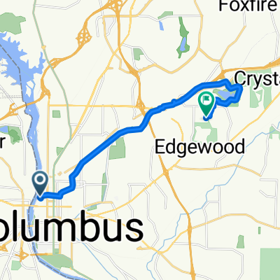
Chattahoochee River Walk
Trasa rowerowa rozpoczynająca się w Phenix City, Alabama, USA.
Przegląd
O tej trasie
Ładna trasa na ponad 20 mil w obie strony. Krajobraz zmienia się od miejskiego frontu rzeki do leśnego rezerwatu przyrody, a na końcu kończy się u podnóża Fort Benning. To może być także przyjemna przejażdżka dla rodzin na krótszych dystansach. Trasa wiedzie obok pól golfowych, dwóch muzeów, centrum przyrody, zadaszonego mostu pieszego i kilku innych mostów nad wodą.
- -:--
- Czas
- 17,4 km
- Dystans
- 133 m
- Przewyższenia
- 90 m
- Spadek
- ---
- Śr. Prędkość
- ---
- Maks. wysokość
Jakość trasy
Typy dróg i nawierzchnie na trasie
Typy dróg
Droga rowerowa
16,3 km
(94 %)
Droga
0,5 km
(3 %)
Powierzchnie
Utwardzona
13 km
(75 %)
Asfalt
11 km
(63 %)
Nawierzchnia (nieokreślona)
2,1 km
(12 %)
Niezdefiniowany
4,3 km
(25 %)
Najważniejsze punkty trasy
Punkty zainteresowania na trasie
Interesujące miejsce po 3,2 km
Head up the hill for the National Civil War Museum
Interesujące miejsce po 13,3 km
Ox Bow Meadows Nature Center
Interesujące miejsce po 13,6 km
To the left is the National Infantry Museum
Interesujące miejsce po 14,4 km
Entry to Fort Benning
Kontynuuj z Bikemap
Użyj, edytuj lub pobierz tę trasę rowerową
Chcesz przejechać trasę Chattahoochee River Walk lub dostosować ją do swojej wycieczki? Oto, co możesz zrobić z tą trasą na Bikemap:
Darmowe funkcje
- Zapisz tę trasę jako ulubioną lub w kolekcji
- Skopiuj i zaplanuj swoją wersję tej trasy
- Synchronizuj swoją trasę z Garminem lub Wahoo
Funkcje Premium
3 dni bezpłatnej wersji próbnej lub jednorazowa opłata. Dowiedz się więcej o Bikemap Premium.
- Nawiguj po tej trasie na iOS i Androidzie
- Eksportuj plik GPX / KML tej trasy
- Stwórz swój własny wydruk (wypróbuj za darmo)
- Pobierz tę trasę do nawigacji offline
Odkryj więcej funkcji Premium.
Uzyskaj Bikemap PremiumOd naszej społeczności
Phenix City: Inne popularne trasy rozpoczynające się tutaj
 7965 Oakmont Ct, Columbus to 7965 Oakmont Ct, Columbus
- Dystans
- 40,1 km
- Przewyższenia
- 66 m
- Spadek
- 133 m
- Lokalizacja
- Phenix City, Alabama, USA
 Chattahoochee River Walk
- Dystans
- 17,4 km
- Przewyższenia
- 133 m
- Spadek
- 90 m
- Lokalizacja
- Phenix City, Alabama, USA
 7961 Oakmont Ct, Columbus to 7965 Oakmont Ct, Columbus
- Dystans
- 55,6 km
- Przewyższenia
- 347 m
- Spadek
- 340 m
- Lokalizacja
- Phenix City, Alabama, USA
 15th Street - Pickering Drive
- Dystans
- 13,8 km
- Przewyższenia
- 109 m
- Spadek
- 93 m
- Lokalizacja
- Phenix City, Alabama, USA
 1006–1010 Bay Ave, Columbus to Lake Oliver Rd, Columbus
- Dystans
- 8,3 km
- Przewyższenia
- 101 m
- Spadek
- 67 m
- Lokalizacja
- Phenix City, Alabama, USA
 Columbus, GA
- Dystans
- 12,3 km
- Przewyższenia
- 35 m
- Spadek
- 72 m
- Lokalizacja
- Phenix City, Alabama, USA
 Cross Country 1/6/21
- Dystans
- 73,5 km
- Przewyższenia
- 515 m
- Spadek
- 507 m
- Lokalizacja
- Phenix City, Alabama, USA
 west trail Phenix City al
- Dystans
- 0,5 km
- Przewyższenia
- 0 m
- Spadek
- 9 m
- Lokalizacja
- Phenix City, Alabama, USA
Otwórz ją w aplikacji

