
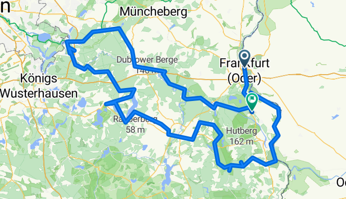
Oder-Spree-Tour - Frankfurt (Oder) to Wiesenau
Trasa rowerowa rozpoczynająca się w Frankfurt nad Odrą, Brandenburgia, Niemcy.
Przegląd
O tej trasie
Trasa Oder-Spree-Tour to pętla o długości około 278 km przez jeziora, rzeki, lasy i kanały wschodniego Brandenburgii. Zwykle zajmuje około czterech dni i zaczyna się oraz kończy we Frankfurcie nad Odrą, niedaleko Berlina. Większość trasy prowadzi cichymi ścieżkami rowerowymi i drogami leśnymi zamkniętymi dla ruchu samochodowego, co sprawia, że jazda jest spokojna i bezpieczna. Tylko krótkie odcinki biegną bezpośrednio wzdłuż Odry i Sprewy, podczas gdy znaczną część trasy stanowią kanały, takie jak Kanał Oder-Spree i Kanał Fryderyka Wilhelma. Krajobraz to mieszanka lasów, jezior i zabytków kultury, takich jak klasztory, średniowieczne miasteczka i śluzy. Wyróżniające się miejsca to opactwo Neuzelle, stare centrum Beeskow, uzdrowisko Bad Saarow i kilka historycznych dróg wodnych. Trasa jest płaska, dobrze oznakowana i wspierana przez dobre połączenia kolejowe, co ułatwia dopasowanie jej do krótszych wycieczek.
- -:--
- Czas
- 289,4 km
- Dystans
- 1362 m
- Przewyższenia
- 1357 m
- Spadek
- ---
- Śr. Prędkość
- 139 m
- Maks. wysokość

Zdjęcia trasy
 to Wiesenau”")
 to Wiesenau”")
 to Wiesenau”")
 to Wiesenau”")
Jakość trasy
Typy dróg i nawierzchnie na trasie
Typy dróg
Ścieżka
101,3 km
(35 %)
Spokojna droga
95,5 km
(33 %)
Powierzchnie
Utwardzona
231,5 km
(80 %)
Nieutwardzona
5,8 km
(2 %)
Asfalt
219,9 km
(76 %)
Nawierzchnia (nieokreślona)
5,8 km
(2 %)
Kontynuuj z Bikemap
Użyj, edytuj lub pobierz tę trasę rowerową
Chcesz przejechać trasę Oder-Spree-Tour - Frankfurt (Oder) to Wiesenau lub dostosować ją do swojej wycieczki? Oto, co możesz zrobić z tą trasą na Bikemap:
Darmowe funkcje
- Zapisz tę trasę jako ulubioną lub w kolekcji
- Skopiuj i zaplanuj swoją wersję tej trasy
- Podziel trasę na etapy, aby utworzyć kilkudniową wycieczkę
- Synchronizuj swoją trasę z Garminem lub Wahoo
Funkcje Premium
3 dni bezpłatnej wersji próbnej lub jednorazowa opłata. Dowiedz się więcej o Bikemap Premium.
- Nawiguj po tej trasie na iOS i Androidzie
- Eksportuj plik GPX / KML tej trasy
- Stwórz swój własny wydruk (wypróbuj za darmo)
- Pobierz tę trasę do nawigacji offline
Odkryj więcej funkcji Premium.
Uzyskaj Bikemap PremiumOd naszej społeczności
Frankfurt nad Odrą: Inne popularne trasy rozpoczynające się tutaj
 Trip 2021-03-02
- Dystans
- 51,5 km
- Przewyższenia
- 287 m
- Spadek
- 298 m
- Lokalizacja
- Frankfurt nad Odrą, Brandenburgia, Niemcy
 05_FrankfurtOder – Groß Neuendorf
- Dystans
- 58,4 km
- Przewyższenia
- 53 m
- Spadek
- 70 m
- Lokalizacja
- Frankfurt nad Odrą, Brandenburgia, Niemcy
 Frankfurt Oder schönes Umland
- Dystans
- 60,9 km
- Przewyższenia
- 175 m
- Spadek
- 172 m
- Lokalizacja
- Frankfurt nad Odrą, Brandenburgia, Niemcy
 adfc Sternfahrt 2013 / 12. Route Frankfurt (Oder)
- Dystans
- 111,5 km
- Przewyższenia
- 158 m
- Spadek
- 179 m
- Lokalizacja
- Frankfurt nad Odrą, Brandenburgia, Niemcy
 Frankfurt "Große Acht"
- Dystans
- 49,5 km
- Przewyższenia
- 167 m
- Spadek
- 174 m
- Lokalizacja
- Frankfurt nad Odrą, Brandenburgia, Niemcy
 Rowerem dookoła POLSKI
- Dystans
- 3549,8 km
- Przewyższenia
- 2307 m
- Spadek
- 2307 m
- Lokalizacja
- Frankfurt nad Odrą, Brandenburgia, Niemcy
 Duża Helena
- Dystans
- 39,4 km
- Przewyższenia
- 140 m
- Spadek
- 140 m
- Lokalizacja
- Frankfurt nad Odrą, Brandenburgia, Niemcy
 Frank.A.-Hafenstr.-Drzecin-Nowe-B.-Rybocice-Fra.
- Dystans
- 41,9 km
- Przewyższenia
- 137 m
- Spadek
- 135 m
- Lokalizacja
- Frankfurt nad Odrą, Brandenburgia, Niemcy
Otwórz ją w aplikacji