

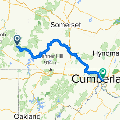
Four ridge route out of Ohiopyle
Trasa rowerowa rozpoczynająca się w Dunbar, Pensylwania, USA.
Przegląd
O tej trasie
Woda i jedzenie dostępne są w sklepach w Confluence. Zjazd na Turkeyfoot wymaga ostrożności, ponieważ droga jest w złym stanie. Mapa pokazuje miejsce do zawracania na Jim Mountain Road w najniższym punkcie. Z dodatkowym podjazdem na stromej rampie, trasę można by przedłużyć do Normalville po wodę i jedzenie.
- -:--
- Czas
- 103,8 km
- Dystans
- 1863 m
- Przewyższenia
- 1857 m
- Spadek
- ---
- Śr. Prędkość
- ---
- Maks. wysokość
Jakość trasy
Typy dróg i nawierzchnie na trasie
Typy dróg
Droga
45,7 km
(44 %)
Spokojna droga
24,9 km
(24 %)
Powierzchnie
Utwardzona
45,7 km
(44 %)
Asfalt
43,6 km
(42 %)
Nawierzchnia (nieokreślona)
2,1 km
(2 %)
Niezdefiniowany
58,1 km
(56 %)
Kontynuuj z Bikemap
Użyj, edytuj lub pobierz tę trasę rowerową
Chcesz przejechać trasę Four ridge route out of Ohiopyle lub dostosować ją do swojej wycieczki? Oto, co możesz zrobić z tą trasą na Bikemap:
Darmowe funkcje
- Zapisz tę trasę jako ulubioną lub w kolekcji
- Skopiuj i zaplanuj swoją wersję tej trasy
- Podziel trasę na etapy, aby utworzyć kilkudniową wycieczkę
- Synchronizuj swoją trasę z Garminem lub Wahoo
Funkcje Premium
3 dni bezpłatnej wersji próbnej lub jednorazowa opłata. Dowiedz się więcej o Bikemap Premium.
- Nawiguj po tej trasie na iOS i Androidzie
- Eksportuj plik GPX / KML tej trasy
- Stwórz swój własny wydruk (wypróbuj za darmo)
- Pobierz tę trasę do nawigacji offline
Odkryj więcej funkcji Premium.
Uzyskaj Bikemap PremiumOd naszej społeczności
Dunbar: Inne popularne trasy rozpoczynające się tutaj
 Ohiopyle to confluence
- Dystans
- 17,5 km
- Przewyższenia
- 44 m
- Spadek
- 19 m
- Lokalizacja
- Dunbar, Pensylwania, USA
 Ohiopyle
- Dystans
- 25,3 km
- Przewyższenia
- 1126 m
- Spadek
- 1126 m
- Lokalizacja
- Dunbar, Pensylwania, USA
 Day 2
Day 2- Dystans
- 104,3 km
- Przewyższenia
- 2183 m
- Spadek
- 2359 m
- Lokalizacja
- Dunbar, Pensylwania, USA
 Holland Hill Road, Dunbar to Holland Hill Road, Dunbar
- Dystans
- 0 km
- Przewyższenia
- 5 m
- Spadek
- 0 m
- Lokalizacja
- Dunbar, Pensylwania, USA
 Four ridge route out of Ohiopyle
- Dystans
- 103,8 km
- Przewyższenia
- 1863 m
- Spadek
- 1857 m
- Lokalizacja
- Dunbar, Pensylwania, USA
 Ohiopyle to West Newton
- Dystans
- 68,1 km
- Przewyższenia
- 154 m
- Spadek
- 297 m
- Lokalizacja
- Dunbar, Pensylwania, USA
 Dunbar - Meyersdale
- Dystans
- 62,6 km
- Przewyższenia
- 1423 m
- Spadek
- 1253 m
- Lokalizacja
- Dunbar, Pensylwania, USA
 Aug 22, 2015, 1:45 PM
- Dystans
- 30,3 km
- Przewyższenia
- 391 m
- Spadek
- 376 m
- Lokalizacja
- Dunbar, Pensylwania, USA
Otwórz ją w aplikacji