Burlington to Bellingham
Trasa rowerowa rozpoczynająca się w Burlington, Waszyngton, USA.
Przegląd
O tej trasie
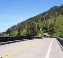
Pierwsza połowa do dwóch trzecich jazdy była praktycznie płaska przez ładne tereny rolnicze. Po płaskim odcinku trasy weszliśmy na Chuckanut Drive, która jest naprawdę piękną drogą wzdłuż wybrzeża na południe od Bellingham, która kilka razy wznosi się i opada. Jedynymi wadami są trochę za duży ruch, chociaż dla nas nie był on niekomfortowy, oraz brak pobocza. Jest kilka punktów widokowych, chociaż ze względu na rosnące pod punktami drzewa, widok na Puget Sound był ładny, ale nie tak panoramiczny, jak mógłby być. Ogólnie wspaniała jazda z dobrymi warunkami drogowymi oraz ładnymi krajobrazami i widokami.
- 4 h 27 min
- Czas
- 52,8 km
- Dystans
- 635 m
- Przewyższenia
- 590 m
- Spadek
- 11,9 km/h
- Śr. Prędkość
- 98 m
- Maks. wysokość
Zdjęcia trasy
Jakość trasy
Typy dróg i nawierzchnie na trasie
Typy dróg
Droga
16,4 km
(31 %)
Spokojna droga
3,2 km
(6 %)
Powierzchnie
Utwardzona
31,7 km
(60 %)
Asfalt
30,1 km
(57 %)
Beton
1,6 km
(3 %)
Niezdefiniowany
21,1 km
(40 %)
Kontynuuj z Bikemap
Użyj, edytuj lub pobierz tę trasę rowerową
Chcesz przejechać trasę Burlington to Bellingham lub dostosować ją do swojej wycieczki? Oto, co możesz zrobić z tą trasą na Bikemap:
Darmowe funkcje
- Zapisz tę trasę jako ulubioną lub w kolekcji
- Skopiuj i zaplanuj swoją wersję tej trasy
- Synchronizuj swoją trasę z Garminem lub Wahoo
Funkcje Premium
3 dni bezpłatnej wersji próbnej lub jednorazowa opłata. Dowiedz się więcej o Bikemap Premium.
- Nawiguj po tej trasie na iOS i Androidzie
- Eksportuj plik GPX / KML tej trasy
- Stwórz swój własny wydruk (wypróbuj za darmo)
- Pobierz tę trasę do nawigacji offline
Odkryj więcej funkcji Premium.
Uzyskaj Bikemap PremiumOd naszej społeczności
Burlington: Inne popularne trasy rozpoczynające się tutaj
 Recording from October 24, 11:54 PM
- Dystans
- 7,6 km
- Przewyższenia
- 9 m
- Spadek
- 11 m
- Lokalizacja
- Burlington, Waszyngton, USA
 Mt. Constitution
- Dystans
- 265 km
- Przewyższenia
- 682 m
- Spadek
- 550 m
- Lokalizacja
- Burlington, Waszyngton, USA
 2012 Skagit Spring Classic 45-Mile Route
- Dystans
- 75,9 km
- Przewyższenia
- 254 m
- Spadek
- 254 m
- Lokalizacja
- Burlington, Waszyngton, USA
 Burlington to Bellingham
- Dystans
- 52,8 km
- Przewyższenia
- 635 m
- Spadek
- 590 m
- Lokalizacja
- Burlington, Waszyngton, USA
 5530 Chuckanut Dr, Bow to 14969 W Bow Hill Rd, Bow
- Dystans
- 47,1 km
- Przewyższenia
- 761 m
- Spadek
- 758 m
- Lokalizacja
- Burlington, Waszyngton, USA
 Bow-SedroWoolley-MtVernon-EdisonLoop20201121
- Dystans
- 68,7 km
- Przewyższenia
- 206 m
- Spadek
- 206 m
- Lokalizacja
- Burlington, Waszyngton, USA
 EdisonSchool-SamishIsland
- Dystans
- 20,5 km
- Przewyższenia
- 62 m
- Spadek
- 63 m
- Lokalizacja
- Burlington, Waszyngton, USA
 Recording from October 25, 12:35 AM
- Dystans
- 7,3 km
- Przewyższenia
- 10 m
- Spadek
- 8 m
- Lokalizacja
- Burlington, Waszyngton, USA
Otwórz ją w aplikacji


