

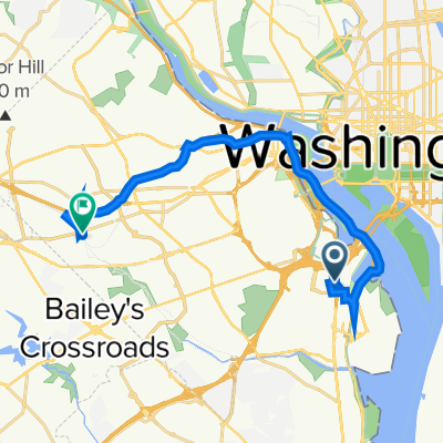
Capital Crescent - Georgetown Branch - Rock Crek Loop
Trasa rowerowa rozpoczynająca się w Waszyngton, Dystrykt Kolumbii, USA.
Przegląd
O tej trasie
To idealna pętla o długości 20 mil z bardzo małym ruchem i niewielką zmianą wysokości.
Na północnym końcu (Georgetown Branch) jest około jednej lub dwóch mil luźnego żwiru, ale reszta to wyasfaltowana ścieżka lub stosunkowo ciche drogi.
Nie jest to zalecane w godzinach szczytu, ponieważ Beach Drive w Rock Creek Park może być zatłoczona. Są alternatywne szlaki, ale ich jakość nawierzchni jest niezbyt dobra (dziury, itp.).
- -:--
- Czas
- 32,5 km
- Dystans
- 172 m
- Przewyższenia
- 174 m
- Spadek
- ---
- Śr. Prędkość
- ---
- Maks. wysokość
Kontynuuj z Bikemap
Użyj, edytuj lub pobierz tę trasę rowerową
Chcesz przejechać trasę Capital Crescent - Georgetown Branch - Rock Crek Loop lub dostosować ją do swojej wycieczki? Oto, co możesz zrobić z tą trasą na Bikemap:
Darmowe funkcje
- Zapisz tę trasę jako ulubioną lub w kolekcji
- Skopiuj i zaplanuj swoją wersję tej trasy
- Synchronizuj swoją trasę z Garminem lub Wahoo
Funkcje Premium
3 dni bezpłatnej wersji próbnej lub jednorazowa opłata. Dowiedz się więcej o Bikemap Premium.
- Nawiguj po tej trasie na iOS i Androidzie
- Eksportuj plik GPX / KML tej trasy
- Stwórz swój własny wydruk (wypróbuj za darmo)
- Pobierz tę trasę do nawigacji offline
Odkryj więcej funkcji Premium.
Uzyskaj Bikemap PremiumOd naszej społeczności
Waszyngton: Inne popularne trasy rozpoczynające się tutaj
 2023 Coast-to-Coast (East-West) FINAL: 03Jun-28Jul2023
- Dystans
- 6108 km
- Przewyższenia
- 25 430 m
- Spadek
- 25 472 m
- Lokalizacja
- Waszyngton, Dystrykt Kolumbii, USA
 DC-DunnLoring-Springfield-Mt.Vermont-DC
- Dystans
- 84,4 km
- Przewyższenia
- 297 m
- Spadek
- 297 m
- Lokalizacja
- Waszyngton, Dystrykt Kolumbii, USA
 Washington Great Falls
- Dystans
- 42,8 km
- Przewyższenia
- 295 m
- Spadek
- 290 m
- Lokalizacja
- Waszyngton, Dystrykt Kolumbii, USA
 ANACOSTIA RIVER TRIAL RIDE
- Dystans
- 28,5 km
- Przewyższenia
- 53 m
- Spadek
- 53 m
- Lokalizacja
- Waszyngton, Dystrykt Kolumbii, USA
 Rock Park 14 - 1
- Dystans
- 21,6 km
- Przewyższenia
- 214 m
- Spadek
- 218 m
- Lokalizacja
- Waszyngton, Dystrykt Kolumbii, USA
 1211 S Eads St, Arlington to 601 N Manchester St, Arlington
- Dystans
- 18,7 km
- Przewyższenia
- 4 m
- Spadek
- 14 m
- Lokalizacja
- Waszyngton, Dystrykt Kolumbii, USA
 1925 Constitution Ave NW, Washington to Constitution Ave NW, Washington
- Dystans
- 15,8 km
- Przewyższenia
- 3 m
- Spadek
- 9 m
- Lokalizacja
- Waszyngton, Dystrykt Kolumbii, USA
 Capital Crescent Loop
- Dystans
- 24 km
- Przewyższenia
- 153 m
- Spadek
- 154 m
- Lokalizacja
- Waszyngton, Dystrykt Kolumbii, USA
Otwórz ją w aplikacji