

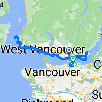
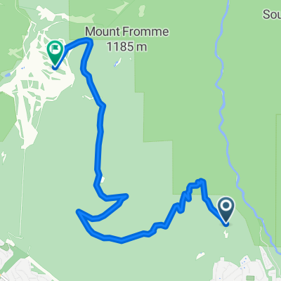
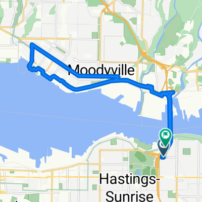
Central Lonsdale - Circle to Cypress Mountain Ski Station
Trasa rowerowa rozpoczynająca się w North Vancouver, Kolumbia Brytyjska, Kanada.
Przegląd
O tej trasie
This was an excellent ride on roads with bike lanes, some unpaved trail, some residential streets, and Cypress Bowl Road, which is a major road, but it had very little traffic. It was an excellent climb to some altitude above 900 meters. Due to all the trees, there were only a few places where one could see the view from Cypress Bowl Road. It was pretty spectacular when one could see it.
- 5 h 46 min
- Czas
- 56,1 km
- Dystans
- 1594 m
- Przewyższenia
- 1576 m
- Spadek
- 9,7 km/h
- Śr. Prędkość
- 922 m
- Maks. wysokość

Zdjęcia trasy


Jakość trasy
Typy dróg i nawierzchnie na trasie
Typy dróg
Droga
40,9 km
(73 %)
Spokojna droga
6,2 km
(11 %)
Powierzchnie
Utwardzona
24,1 km
(43 %)
Nieutwardzona
1,7 km
(3 %)
Asfalt
23,6 km
(42 %)
Nieutwardzony (nieokreślony)
1,1 km
(2 %)
Kontynuuj z Bikemap
Użyj, edytuj lub pobierz tę trasę rowerową
Chcesz przejechać trasę Central Lonsdale - Circle to Cypress Mountain Ski Station lub dostosować ją do swojej wycieczki? Oto, co możesz zrobić z tą trasą na Bikemap:
Darmowe funkcje
- Zapisz tę trasę jako ulubioną lub w kolekcji
- Skopiuj i zaplanuj swoją wersję tej trasy
- Synchronizuj swoją trasę z Garminem lub Wahoo
Funkcje Premium
3 dni bezpłatnej wersji próbnej lub jednorazowa opłata. Dowiedz się więcej o Bikemap Premium.
- Nawiguj po tej trasie na iOS i Androidzie
- Eksportuj plik GPX / KML tej trasy
- Stwórz swój własny wydruk (wypróbuj za darmo)
- Pobierz tę trasę do nawigacji offline
Odkryj więcej funkcji Premium.
Uzyskaj Bikemap PremiumOd naszej społeczności
North Vancouver: Inne popularne trasy rozpoczynające się tutaj
 Keith Rd E, North Vancouver to Gilmore Ave N, Burnaby
- Dystans
- 77,6 km
- Przewyższenia
- 958 m
- Spadek
- 874 m
- Lokalizacja
- North Vancouver, Kolumbia Brytyjska, Kanada
 Hike Rice Lake Lynn Loop 9.5 km
- Dystans
- 9,6 km
- Przewyższenia
- 294 m
- Spadek
- 291 m
- Lokalizacja
- North Vancouver, Kolumbia Brytyjska, Kanada
 Fromme parking lot to Grouse Mt, North Vancouver
- Dystans
- 9,1 km
- Przewyższenia
- 688 m
- Spadek
- 54 m
- Lokalizacja
- North Vancouver, Kolumbia Brytyjska, Kanada
 Loop: 2nd Narrow Bridge (BBY) + Lonsdale Mall (N. Van)
- Dystans
- 15,7 km
- Przewyższenia
- 159 m
- Spadek
- 170 m
- Lokalizacja
- North Vancouver, Kolumbia Brytyjska, Kanada
 Lillooet Road 2000, North Vancouver to Lillooet Road 2000, North Vancouver
- Dystans
- 31 km
- Przewyższenia
- 311 m
- Spadek
- 272 m
- Lokalizacja
- North Vancouver, Kolumbia Brytyjska, Kanada
 CVG - BMUT - TCT
- Dystans
- 32,4 km
- Przewyższenia
- 223 m
- Spadek
- 226 m
- Lokalizacja
- North Vancouver, Kolumbia Brytyjska, Kanada
 161 E Sixth St, North Vancouver to 595 Keith Rd, West Vancouver
- Dystans
- 6,9 km
- Przewyższenia
- 60 m
- Spadek
- 92 m
- Lokalizacja
- North Vancouver, Kolumbia Brytyjska, Kanada
 Sreveston
- Dystans
- 75,4 km
- Przewyższenia
- 211 m
- Spadek
- 208 m
- Lokalizacja
- North Vancouver, Kolumbia Brytyjska, Kanada
Otwórz ją w aplikacji