

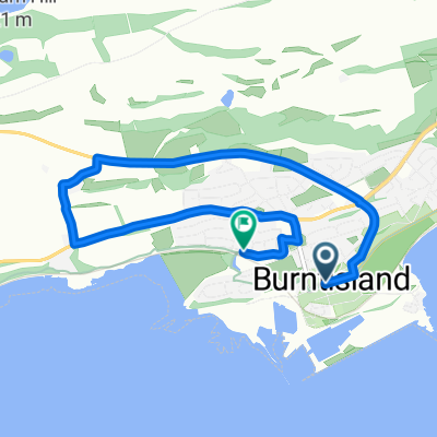
St Margaret's Way-Burntisland to Leven
Trasa rowerowa rozpoczynająca się w Burntisland, Szkocja, Zjednoczone Królestwo Wielkiej Brytanii.
Przegląd
O tej trasie
Going out Burntisland along a short strip of main road ,with a pedestrian walkway alongside, the Way returns to a quiet section of the Fife Coastal Path, past Kinghorn , where a Scottish king fell to his death, and onto Kirkcaldy, once the linoleum capital of Scotland . The path can become muddy as it skirts the coast. Across the water, the extinct volcanoes of the Bass Rock and North Berwick Law are visible.
Leaving Kirkcaldy and passing the grandly built old linoleum factory the Way descends abruptly to the beach, with the 15th century Ravenscraig Castle towering above. Then the Way follows the signposted Fife Coastal Path through former fishing and coalmining villages and past ancient buildings and memorials to Lundin Links and Leven.
This is the 3rd section of St Margaret’s Way, the great 100km pilgrimage trail from Edinburgh to St Andrews, part of the revival of the 1000 year old pilgrimage, The Way of St Andrews. (http://www.thewayofstandrews.com)
- -:--
- Czas
- 23,8 km
- Dystans
- 126 m
- Przewyższenia
- 119 m
- Spadek
- ---
- Śr. Prędkość
- ---
- Maks. wysokość

Najważniejsze punkty trasy
Punkty zainteresowania na trasie

Interesujące miejsce po 7,3 km
This limestone bed was formed at the bottom of a warm shallow sea when this part of Scotland was near the Equator. Here the bed has been compressed horizontally so the hard limestone has cracked and one slab has slid over the other. This feature is called a thrust fault. More signs of volcanic activity lie just south of the breakwater. Here there is a reef formed by molten rock (basalt), which has squeezed between horizontal layers of sandstone. This feature is called a sill. Thanks to geoHeritage Fife for advice and image.
Kontynuuj z Bikemap
Użyj, edytuj lub pobierz tę trasę rowerową
Chcesz przejechać trasę St Margaret's Way-Burntisland to Leven lub dostosować ją do swojej wycieczki? Oto, co możesz zrobić z tą trasą na Bikemap:
Darmowe funkcje
- Zapisz tę trasę jako ulubioną lub w kolekcji
- Skopiuj i zaplanuj swoją wersję tej trasy
- Synchronizuj swoją trasę z Garminem lub Wahoo
Funkcje Premium
3 dni bezpłatnej wersji próbnej lub jednorazowa opłata. Dowiedz się więcej o Bikemap Premium.
- Nawiguj po tej trasie na iOS i Androidzie
- Eksportuj plik GPX / KML tej trasy
- Stwórz swój własny wydruk (wypróbuj za darmo)
- Pobierz tę trasę do nawigacji offline
Odkryj więcej funkcji Premium.
Uzyskaj Bikemap PremiumOd naszej społeczności
Burntisland: Inne popularne trasy rozpoczynające się tutaj
 InvkLeuc
- Dystans
- 60,7 km
- Przewyższenia
- 464 m
- Spadek
- 465 m
- Lokalizacja
- Burntisland, Szkocja, Zjednoczone Królestwo Wielkiej Brytanii
 BIsCupar
- Dystans
- 47,3 km
- Przewyższenia
- 369 m
- Spadek
- 354 m
- Lokalizacja
- Burntisland, Szkocja, Zjednoczone Królestwo Wielkiej Brytanii
 Lengthy bike tour from カーコーディー to セントアンドリューズ
- Dystans
- 52,2 km
- Przewyższenia
- 390 m
- Spadek
- 492 m
- Lokalizacja
- Burntisland, Szkocja, Zjednoczone Królestwo Wielkiej Brytanii
 St Margaret's Way-Burntisland to Leven
- Dystans
- 23,8 km
- Przewyższenia
- 126 m
- Spadek
- 119 m
- Lokalizacja
- Burntisland, Szkocja, Zjednoczone Królestwo Wielkiej Brytanii
 BislLeuc
- Dystans
- 59,8 km
- Przewyższenia
- 429 m
- Spadek
- 418 m
- Lokalizacja
- Burntisland, Szkocja, Zjednoczone Królestwo Wielkiej Brytanii
 School 2
- Dystans
- 5,3 km
- Przewyższenia
- 82 m
- Spadek
- 89 m
- Lokalizacja
- Burntisland, Szkocja, Zjednoczone Królestwo Wielkiej Brytanii
 Tour of the Kingdom Ride 130km route
- Dystans
- 129 km
- Przewyższenia
- 792 m
- Spadek
- 774 m
- Lokalizacja
- Burntisland, Szkocja, Zjednoczone Królestwo Wielkiej Brytanii
Otwórz ją w aplikacji