

Gheerulla Lookout, Oaky Creek Lookout Mountain Bike Trail
Trasa rowerowa rozpoczynająca się w Nambour, State of Queensland, Australia.
Przegląd
O tej trasie
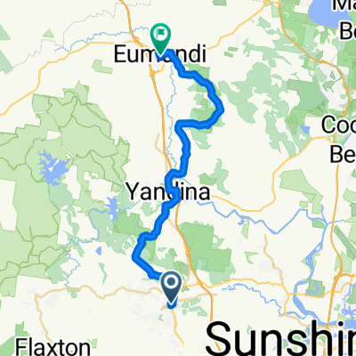
Embark on an exhilarating adventure with the Oaky Creek Lookout Mountain Bike Trail, an intermediate-level e-MTB ride that promises an engaging mix of natural beauty and challenging terrain. Perfect for those hiring an e-MTB from @ecoTekSC, this 19km return trail offers a dynamic biking experience set against the backdrop of Queensland's stunning landscapes.
Trail Overview:
Starting Point: Mapleton Day Use Area Distance: 19km return Difficulty: Intermediate Highlights: Wet eucalypt forests, drier woodlands, and breathtaking views from Oaky Creek Lookout Ride Description: From the Mapleton Day Use Area, set off on a journey that introduces you to various forest communities. The trail begins amid lush, wet eucalypt forests that gradually transition to drier woodlands characterized by a grassy understory. As you ascend towards the ridge, the foliage thins, revealing spectacular vistas at the Oaky Creek Lookout. Here, take a moment to savor the panoramic views of the Conondale Range and the expansive Mary Valley.
Safety and Interaction: Be alert as you navigate sections where the Gheerulla trail bike track intersects, and remember to give way to motorbikes. The area is known for its Blackbutt trees, which can drop branches in strong winds, posing potential hazards. Always stay vigilant to avoid branches that might obstruct your path or cause damage to your e-MTB.
Trail Tips:
For Non-Riders: The wide, forgiving trails are ideal for non-riders too, offering a pleasant setting for hiking or running. For Families: This route is also family-friendly, providing a safe environment for kids to explore the outdoors. Best Time to Ride: Early mornings are magical, offering cooler temperatures and the chance to catch a sunrise over the hinterland. Experience Summary: This trail is not just about biking; it's about immersing yourself in the tranquility of nature. Whether you pause for a picnic or simply to enjoy the silence punctuated by birdsong, the Oaky Creek Lookout Mountain Bike Trail delivers an unforgettable outdoor experience. Pack your sense of adventure and discover the serene, multi-use fire trails of this beautiful National Park area. With the power of an e-MTB from @ecoTekSC, conquer the climbs and enjoy more of the scenery without the strain.
- 1 h 19 min
- Czas
- 18,6 km
- Dystans
- 364 m
- Przewyższenia
- 335 m
- Spadek
- 14,1 km/h
- Śr. Prędkość
- 486 m
- Maks. wysokość

Zdjęcia trasy


Jakość trasy
Typy dróg i nawierzchnie na trasie
Typy dróg
Droga leśna
18,4 km
(99 %)
Ścieżka
0,2 km
(1 %)
Powierzchnie
Nieutwardzona
4,8 km
(26 %)
Ziemia
4,8 km
(26 %)
Niezdefiniowany
13,8 km
(74 %)
Kontynuuj z Bikemap
Użyj, edytuj lub pobierz tę trasę rowerową
Chcesz przejechać trasę Gheerulla Lookout, Oaky Creek Lookout Mountain Bike Trail lub dostosować ją do swojej wycieczki? Oto, co możesz zrobić z tą trasą na Bikemap:
Darmowe funkcje
- Zapisz tę trasę jako ulubioną lub w kolekcji
- Skopiuj i zaplanuj swoją wersję tej trasy
- Synchronizuj swoją trasę z Garminem lub Wahoo
Funkcje Premium
3 dni bezpłatnej wersji próbnej lub jednorazowa opłata. Dowiedz się więcej o Bikemap Premium.
- Nawiguj po tej trasie na iOS i Androidzie
- Eksportuj plik GPX / KML tej trasy
- Stwórz swój własny wydruk (wypróbuj za darmo)
- Pobierz tę trasę do nawigacji offline
Odkryj więcej funkcji Premium.
Uzyskaj Bikemap PremiumOd naszej społeczności
Nambour: Inne popularne trasy rozpoczynające się tutaj
 Nambour to eumundi return
- Dystans
- 29,3 km
- Przewyższenia
- 0 m
- Spadek
- 0 m
- Lokalizacja
- Nambour, State of Queensland, Australia
 mapleton yandina
- Dystans
- 20,9 km
- Przewyższenia
- 265 m
- Spadek
- 621 m
- Lokalizacja
- Nambour, State of Queensland, Australia
 Things To Do Sunshine Coast Top of the Range
- Dystans
- 53,4 km
- Przewyższenia
- 469 m
- Spadek
- 466 m
- Lokalizacja
- Nambour, State of Queensland, Australia
 Montville-Eumundi CLONED FROM ROUTE 452201
- Dystans
- 81,9 km
- Przewyższenia
- 580 m
- Spadek
- 580 m
- Lokalizacja
- Nambour, State of Queensland, Australia
 Explorer Mapleton
- Dystans
- 22 km
- Przewyższenia
- 318 m
- Spadek
- 320 m
- Lokalizacja
- Nambour, State of Queensland, Australia
 Nambour Mapleton 57km 1220m Loop
- Dystans
- 56,9 km
- Przewyższenia
- 1531 m
- Spadek
- 1529 m
- Lokalizacja
- Nambour, State of Queensland, Australia
 Relaxed route in Nambour
- Dystans
- 2,2 km
- Przewyższenia
- 17 m
- Spadek
- 13 m
- Lokalizacja
- Nambour, State of Queensland, Australia
 Nambour-home
- Dystans
- 22,6 km
- Przewyższenia
- 131 m
- Spadek
- 145 m
- Lokalizacja
- Nambour, State of Queensland, Australia
Otwórz ją w aplikacji