

Bangar, bike and Bukit Patoi
Trasa rowerowa rozpoczynająca się w Bangar, Temburong, Brunei.
Przegląd
O tej trasie
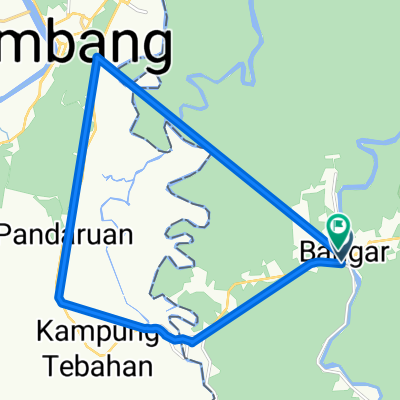
To jest połączenie jazdy na rowerze i spaceru, z Bangaru do Bukit Patoi. Droga to doskonała autostrada, głównie z szerokim poboczem, a 300 m wspinaczka na Bukit Patoi prowadzi bardzo często uczęszczanym szlakiem. U podnóża wspinaczki znajdują się budynki, w tym toalety i woda. Upewnij się, że często pijesz.
Najlepiej to zrobić wcześnie rano, aby uniknąć upału. I tak będziesz dużo się pocić. Zarówno jazda, jak i spacer zajmują nieco ponad pół godziny, więc daj sobie trzy godziny na zwiedzanie i ukończenie tego.
Plecak dzienny z parą antypoślizgowych butów i kilkoma butelkami wody to dobry pomysł. Największym zagrożeniem są śliskie (malowane!) betonowe schody na początku wspinaczki. Trzymaj rękę na poręczy przy schodzeniu, ponieważ deszcz i mech pogarszają sytuację.
- -:--
- Czas
- 16,1 km
- Dystans
- 388 m
- Przewyższenia
- 109 m
- Spadek
- ---
- Śr. Prędkość
- ---
- Maks. wysokość

Kontynuuj z Bikemap
Użyj, edytuj lub pobierz tę trasę rowerową
Chcesz przejechać trasę Bangar, bike and Bukit Patoi lub dostosować ją do swojej wycieczki? Oto, co możesz zrobić z tą trasą na Bikemap:
Darmowe funkcje
- Zapisz tę trasę jako ulubioną lub w kolekcji
- Skopiuj i zaplanuj swoją wersję tej trasy
- Synchronizuj swoją trasę z Garminem lub Wahoo
Funkcje Premium
3 dni bezpłatnej wersji próbnej lub jednorazowa opłata. Dowiedz się więcej o Bikemap Premium.
- Nawiguj po tej trasie na iOS i Androidzie
- Eksportuj plik GPX / KML tej trasy
- Stwórz swój własny wydruk (wypróbuj za darmo)
- Pobierz tę trasę do nawigacji offline
Odkryj więcej funkcji Premium.
Uzyskaj Bikemap PremiumOd naszej społeczności
Bangar: Inne popularne trasy rozpoczynające się tutaj
 Temburong Practice Run
- Dystans
- 13 km
- Przewyższenia
- 102 m
- Spadek
- 86 m
- Lokalizacja
- Bangar, Temburong, Brunei
 Bukit Patoi extension walk
- Dystans
- 1,1 km
- Przewyższenia
- 88 m
- Spadek
- 28 m
- Lokalizacja
- Bangar, Temburong, Brunei
 Blistering ride
- Dystans
- 22,3 km
- Przewyższenia
- 49 m
- Spadek
- 39 m
- Lokalizacja
- Bangar, Temburong, Brunei
 Afternoon Ride
- Dystans
- 15 km
- Przewyższenia
- 157 m
- Spadek
- 133 m
- Lokalizacja
- Bangar, Temburong, Brunei
 Bangar, bike and Bukit Patoi
- Dystans
- 16,1 km
- Przewyższenia
- 388 m
- Spadek
- 109 m
- Lokalizacja
- Bangar, Temburong, Brunei
 Bangar back river cruise
- Dystans
- 29,1 km
- Przewyższenia
- 69 m
- Spadek
- 72 m
- Lokalizacja
- Bangar, Temburong, Brunei
 Restful route
- Dystans
- 40,4 km
- Przewyższenia
- 31 m
- Spadek
- 84 m
- Lokalizacja
- Bangar, Temburong, Brunei
 Temada-Sibut track
- Dystans
- 6,8 km
- Przewyższenia
- 108 m
- Spadek
- 117 m
- Lokalizacja
- Bangar, Temburong, Brunei
Otwórz ją w aplikacji