

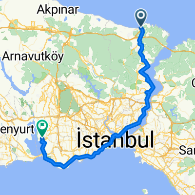
Rumeli Kavağı - Rumeli Feneri (Dogus CICEK)
Trasa rowerowa rozpoczynająca się w Arıköy, Istanbul, Turkey.
Przegląd
O tej trasie
Rumeli Kavagi - Rumeli Feneri - optional Garipce (by Dogus CICEK)
After leaving Rumeli Kavagi, a paved forest route will take the riders to the point where the Bosphorus and the Black Sea joins. There is a place (cafe/restaurant) to eat/drink and re-stock supplies at Rumeli Feneri. The Fener is a historic lighthouse which has a small exhibit about it's past and the view from the seaside is beautiful. Riders can also ride west from the Rumeli Feneri to reach a seaside hotel called Golden Beach consisting of several bungalows of mid-high luxury (beware of the high prices though). Riders can visit "Garipce" on the way back or before Rumeli Feneri, which is several miles south of Rumeli Feneri. Beware that the road turning into Garipce from the forest road you came may be gravel or dirt so road bike riders better be cautious. Garipce is a fishing village with a restaurant. And of course the best place to visit while in Garipce is the ruins of an old castle and redoubt which is located just at the north-side of the village. (You have to go one floor underground to walk in the redoubt - beware that the redoubt is uniluminated so better go in during daytime) Garipce is said to be razed to the gorund in the years to come because of the plans to build a third bridge across the Bosphorus so it is a great time to see the place before is destroyed.
- -:--
- Czas
- 11,7 km
- Dystans
- 235 m
- Przewyższenia
- 227 m
- Spadek
- ---
- Śr. Prędkość
- ---
- Maks. wysokość
Kontynuuj z Bikemap
Użyj, edytuj lub pobierz tę trasę rowerową
Chcesz przejechać trasę Rumeli Kavağı - Rumeli Feneri (Dogus CICEK) lub dostosować ją do swojej wycieczki? Oto, co możesz zrobić z tą trasą na Bikemap:
Darmowe funkcje
- Zapisz tę trasę jako ulubioną lub w kolekcji
- Skopiuj i zaplanuj swoją wersję tej trasy
- Synchronizuj swoją trasę z Garminem lub Wahoo
Funkcje Premium
3 dni bezpłatnej wersji próbnej lub jednorazowa opłata. Dowiedz się więcej o Bikemap Premium.
- Nawiguj po tej trasie na iOS i Androidzie
- Eksportuj plik GPX / KML tej trasy
- Stwórz swój własny wydruk (wypróbuj za darmo)
- Pobierz tę trasę do nawigacji offline
Odkryj więcej funkcji Premium.
Uzyskaj Bikemap PremiumOd naszej społeczności
Arıköy: Inne popularne trasy rozpoczynające się tutaj
 KOC University - Rumeli Kavagi - Sariyer
- Dystans
- 15,3 km
- Przewyższenia
- 357 m
- Spadek
- 377 m
- Lokalizacja
- Arıköy, Istanbul, Turkey
 Etape 25
- Dystans
- 68,5 km
- Przewyższenia
- 365 m
- Spadek
- 374 m
- Lokalizacja
- Arıköy, Istanbul, Turkey
 Arıköy Cycling
- Dystans
- 13 km
- Przewyższenia
- 90 m
- Spadek
- 93 m
- Lokalizacja
- Arıköy, Istanbul, Turkey
 Rumeli Kavağı - Rumeli Feneri (Dogus CICEK)
- Dystans
- 11,7 km
- Przewyższenia
- 235 m
- Spadek
- 227 m
- Lokalizacja
- Arıköy, Istanbul, Turkey
 Arıköy Cycling
- Dystans
- 14,7 km
- Przewyższenia
- 368 m
- Spadek
- 365 m
- Lokalizacja
- Arıköy, Istanbul, Turkey
 Sinpas - Rumeli Feneri loop
- Dystans
- 18,2 km
- Przewyższenia
- 325 m
- Spadek
- 325 m
- Lokalizacja
- Arıköy, Istanbul, Turkey
 Moderate route in Sariyer
- Dystans
- 15,1 km
- Przewyższenia
- 460 m
- Spadek
- 451 m
- Lokalizacja
- Arıköy, Istanbul, Turkey
 wk 1 :0-960
- Dystans
- 971,6 km
- Przewyższenia
- 2276 m
- Spadek
- 2154 m
- Lokalizacja
- Arıköy, Istanbul, Turkey
Otwórz ją w aplikacji