

Cotton Tree Caravan Park to Aussie World
Trasa rowerowa rozpoczynająca się w Sunshine Coast, State of Queensland, Australia.
Przegląd
O tej trasie
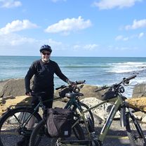
Set off on a picturesque e-bike journey from the relaxed ambiance of Cotton Tree Caravan Park to the thrilling Aussie World and the iconic Banana Bender Pub. This route takes you approximately 20 km along dedicated cycle pathways, skirting the beautiful Mooloolah National Park and venturing into the lush Sunshine Coast hinterland.
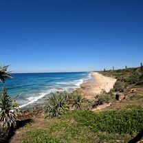
Your adventure begins at the family-friendly Cotton Tree, known for its beautiful beaches and vibrant community atmosphere. From there, you'll head south, enjoying the coastal views as you move towards Mooloolaba. The path then takes you through the serene environments of the Mooloolah National Park, where you can enjoy the rich native flora and fauna.
As you leave the coast behind, the route shifts into the hinterland, offering a mix of hillier terrain with rewarding vistas. Your destination, Aussie World, is one of the Sunshine Coast’s top attractions, providing a variety of rides and games for all ages. Right next door, the Banana Bender Pub offers a perfect spot to relax and refuel with delicious food and a good selection of drinks in a uniquely Australian setting.
This bikemap is ideal for those looking to combine a bit of adventure with sightseeing. It’s suited for riders looking for a moderately easy ride with opportunities to stop, explore, and enjoy the natural and man-made attractions along the way. Perfect for a day out with the family or a fun excursion with friends!
- 2 h 32 min
- Czas
- 40 km
- Dystans
- 225 m
- Przewyższenia
- 227 m
- Spadek
- 15,8 km/h
- Śr. Prędkość
- 40 m
- Maks. wysokość

Zdjęcia trasy


Jakość trasy
Typy dróg i nawierzchnie na trasie
Typy dróg
Droga rowerowa
35,1 km
(88 %)
Strefa dla pieszych
2,3 km
(6 %)
Powierzchnie
Utwardzona
26,1 km
(65 %)
Beton
23,1 km
(58 %)
Asfalt
2,1 km
(5 %)
Kontynuuj z Bikemap
Użyj, edytuj lub pobierz tę trasę rowerową
Chcesz przejechać trasę Cotton Tree Caravan Park to Aussie World lub dostosować ją do swojej wycieczki? Oto, co możesz zrobić z tą trasą na Bikemap:
Darmowe funkcje
- Zapisz tę trasę jako ulubioną lub w kolekcji
- Skopiuj i zaplanuj swoją wersję tej trasy
- Synchronizuj swoją trasę z Garminem lub Wahoo
Funkcje Premium
3 dni bezpłatnej wersji próbnej lub jednorazowa opłata. Dowiedz się więcej o Bikemap Premium.
- Nawiguj po tej trasie na iOS i Androidzie
- Eksportuj plik GPX / KML tej trasy
- Stwórz swój własny wydruk (wypróbuj za darmo)
- Pobierz tę trasę do nawigacji offline
Odkryj więcej funkcji Premium.
Uzyskaj Bikemap PremiumOd naszej społeczności
Sunshine Coast: Inne popularne trasy rozpoczynające się tutaj
 Novatel Twin Waters - Pt Cartwright Retun
- Dystans
- 52,8 km
- Przewyższenia
- 128 m
- Spadek
- 168 m
- Lokalizacja
- Sunshine Coast, State of Queensland, Australia
 Relaxed route in Marcoola
- Dystans
- 10,4 km
- Przewyższenia
- 32 m
- Spadek
- 32 m
- Lokalizacja
- Sunshine Coast, State of Queensland, Australia
 Fishermans Road, Maroochydore to 19 Mudjimba Esplanade, Mudjimba
- Dystans
- 15,6 km
- Przewyższenia
- 0 m
- Spadek
- 8 m
- Lokalizacja
- Sunshine Coast, State of Queensland, Australia
 Easy Peasy Novotel North e-Bike Tour
- Dystans
- 23,3 km
- Przewyższenia
- 32 m
- Spadek
- 77 m
- Lokalizacja
- Sunshine Coast, State of Queensland, Australia
 ThinkChange 2025 Marcoola
- Dystans
- 12,4 km
- Przewyższenia
- 13 m
- Spadek
- 14 m
- Lokalizacja
- Sunshine Coast, State of Queensland, Australia
 Maroochydore Town Centre to Cotton Tree & Fisherman's Road Markets
- Dystans
- 16,5 km
- Przewyższenia
- 44 m
- Spadek
- 48 m
- Lokalizacja
- Sunshine Coast, State of Queensland, Australia
 Mt Coolum
- Dystans
- 13,6 km
- Przewyższenia
- 133 m
- Spadek
- 141 m
- Lokalizacja
- Sunshine Coast, State of Queensland, Australia
 Chambers Island North to Pt Arkwright
- Dystans
- 43,3 km
- Przewyższenia
- 45 m
- Spadek
- 42 m
- Lokalizacja
- Sunshine Coast, State of Queensland, Australia
Otwórz ją w aplikacji