

(Map 2) The Laneways of Kogarah
Trasa rowerowa rozpoczynająca się w Brighton-Le-Sands, Nowa Południowa Walia, Australia.
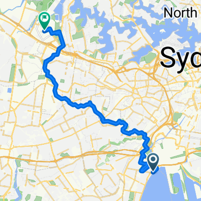
Przegląd
O tej trasie
Uliczki Kogarah mają potencjał, aby zapewnić użyteczne aktywne połączenia transportowe wokół centrum miasta Kogarah.
Ulice charakteryzują się minimalnym ruchem samochodowym i przecinają się z kawiarniami, pubami, biblioteką oraz wiaduktem nad Princess Highway, który połączy się z M6 Etap 1 Aktywnym Połączeniem Transportowym / Kamay Greenway przez President Ave.
W obecnym stanie ulice kierują ruch samochodowy w jednym kierunku, ale mam nadzieję, że w przyszłości będą mogły być wykorzystane jako pasy rowerowe w przeciwnym kierunku.
- 8 min
- Czas
- 2,2 km
- Dystans
- 7 m
- Przewyższenia
- 8 m
- Spadek
- 16 km/h
- Śr. Prędkość
- 32 m
- Maks. wysokość

Kontynuuj z Bikemap
Użyj, edytuj lub pobierz tę trasę rowerową
Chcesz przejechać trasę (Map 2) The Laneways of Kogarah lub dostosować ją do swojej wycieczki? Oto, co możesz zrobić z tą trasą na Bikemap:
Darmowe funkcje
- Zapisz tę trasę jako ulubioną lub w kolekcji
- Skopiuj i zaplanuj swoją wersję tej trasy
- Synchronizuj swoją trasę z Garminem lub Wahoo
Funkcje Premium
3 dni bezpłatnej wersji próbnej lub jednorazowa opłata. Dowiedz się więcej o Bikemap Premium.
- Nawiguj po tej trasie na iOS i Androidzie
- Eksportuj plik GPX / KML tej trasy
- Stwórz swój własny wydruk (wypróbuj za darmo)
- Pobierz tę trasę do nawigacji offline
Odkryj więcej funkcji Premium.
Uzyskaj Bikemap PremiumOd naszej społeczności
Brighton-Le-Sands: Inne popularne trasy rozpoczynające się tutaj
 Brighton-Le-sands/route in Kyeemagh 28/9/19
- Dystans
- 18,4 km
- Przewyższenia
- 40 m
- Spadek
- 40 m
- Lokalizacja
- Brighton-Le-Sands, Nowa Południowa Walia, Australia
 2 Roslyn Avenue, Brighton-Le-Sands to 1A Roslyn Avenue, Brighton-Le-Sands
- Dystans
- 12,2 km
- Przewyższenia
- 3 m
- Spadek
- 10 m
- Lokalizacja
- Brighton-Le-Sands, Nowa Południowa Walia, Australia
 Cook Park Trail, Brighton-Le-Sands to 9 Poole Street, Kingsgrove
- Dystans
- 7,9 km
- Przewyższenia
- 0 m
- Spadek
- 3 m
- Lokalizacja
- Brighton-Le-Sands, Nowa Południowa Walia, Australia
 1A Roslyn Avenue, Brighton-Le-Sands to 1A Roslyn Avenue, Brighton-Le-Sands
- Dystans
- 13,3 km
- Przewyższenia
- 9 m
- Spadek
- 17 m
- Lokalizacja
- Brighton-Le-Sands, Nowa Południowa Walia, Australia
 The Grand Parade, Brighton-Le-Sands to 13-17 Coast Avenue, Cronulla
- Dystans
- 16,6 km
- Przewyższenia
- 0 m
- Spadek
- 6 m
- Lokalizacja
- Brighton-Le-Sands, Nowa Południowa Walia, Australia
 Morning Rides - Flats
- Dystans
- 13,4 km
- Przewyższenia
- 42 m
- Spadek
- 42 m
- Lokalizacja
- Brighton-Le-Sands, Nowa Południowa Walia, Australia
 Cook Park Path, Kyeemagh to Sydney Olympic Park
- Dystans
- 26,7 km
- Przewyższenia
- 141 m
- Spadek
- 130 m
- Lokalizacja
- Brighton-Le-Sands, Nowa Południowa Walia, Australia
 Easy ride in Cronulla
- Dystans
- 20,5 km
- Przewyższenia
- 64 m
- Spadek
- 57 m
- Lokalizacja
- Brighton-Le-Sands, Nowa Południowa Walia, Australia
Otwórz ją w aplikacji