Austin - Circle Exploring Capitol and River
Trasa rowerowa rozpoczynająca się w Rollingwood, Teksas, USA.
Przegląd
O tej trasie
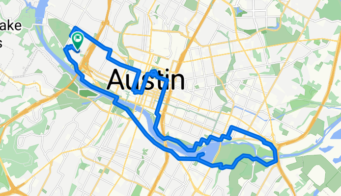
Będąc nowym w Austin, wyszedłem na krótką przejażdżkę, aby trochę zwiedzić wokół jeziora. Najpierw jednak pojechałem do Rosen's Bagels, żeby kupić kilka, aby sprawdzić, czy przypadną do gustu mojej żonie. Potem, ponieważ zobaczyłem kopułę kapitol w drodze do sklepu z bajglami, pojechałem do niego, aby zobaczyć go z bliska. Ładny, dobrze utrzymany budynek.
Z kapitolu zjechałem nad rzekę Colorado (jak się okazuje, nazywaną też Lady Bird Lake) i skręciłem na wschód, aby przejechać przez most dla rowerzystów, aby zrobić okrąg po zachodniej stronie rzeki. W niektórych miejscach korzystałem z utwardzonego ścieżki, a w innych z asfaltowych dróg i pasów dla rowerów równoległych do brzegów rzeki. Odcinek nieutwardzonego szlaku zaraz po moście rowerowym na wschodnim końcu był paroma milami mniej utwardzonego szlaku. Przejezdny, ale wielu rowerzystów szosowych byłoby mniej niż zachwyconych tym odcinkiem.
Przez większość czasu była to ładna przejażdżka wzdłuż i przy rzece, chociaż przez dużą część przejażdżki po południowej stronie byłem na East i West Riverside Dr, które były oznaczone jako trasa rowerowa na mapie, ale które wyraźnie nie powinny były być. Miał dużo ruchu i brak pobocza. Sugeruję, abyście korzystali z innych dróg lub ścieżki dla rowerów wzdłuż tego odcinka. Przypuszczam, że ścieżka rowerowa byłaby utwardzona, ale jeszcze jej nie przejeżdżałem, aby to zobaczyć.
Wracając na most dla pieszych/rowerzystów w pobliżu centrum miasta, przeszedłem przez niego i skorzystałem z dobrze utwardzonej ścieżki, aby zbliżyć się do HEB na zachodnim końcu mojego okręgu na zakupy.
- 3 h
- Czas
- 31,2 km
- Dystans
- 207 m
- Przewyższenia
- 207 m
- Spadek
- 10,4 km/h
- Śr. Prędkość
- 174 m
- Maks. wysokość
Zdjęcia trasy
Jakość trasy
Typy dróg i nawierzchnie na trasie
Typy dróg
Droga rowerowa
6,5 km
(21 %)
Spokojna droga
5,9 km
(19 %)
Powierzchnie
Utwardzona
20,3 km
(65 %)
Nieutwardzona
4,4 km
(14 %)
Asfalt
15,6 km
(50 %)
Luźny żwir
3,1 km
(10 %)
Kontynuuj z Bikemap
Użyj, edytuj lub pobierz tę trasę rowerową
Chcesz przejechać trasę Austin - Circle Exploring Capitol and River lub dostosować ją do swojej wycieczki? Oto, co możesz zrobić z tą trasą na Bikemap:
Darmowe funkcje
- Zapisz tę trasę jako ulubioną lub w kolekcji
- Skopiuj i zaplanuj swoją wersję tej trasy
- Synchronizuj swoją trasę z Garminem lub Wahoo
Funkcje Premium
3 dni bezpłatnej wersji próbnej lub jednorazowa opłata. Dowiedz się więcej o Bikemap Premium.
- Nawiguj po tej trasie na iOS i Androidzie
- Eksportuj plik GPX / KML tej trasy
- Stwórz swój własny wydruk (wypróbuj za darmo)
- Pobierz tę trasę do nawigacji offline
Odkryj więcej funkcji Premium.
Uzyskaj Bikemap PremiumOd naszej społeczności
Rollingwood: Inne popularne trasy rozpoczynające się tutaj
 Austin - Circle to Steiner Ranch
- Dystans
- 56,1 km
- Przewyższenia
- 757 m
- Spadek
- 758 m
- Lokalizacja
- Rollingwood, Teksas, USA
 Austin - Circle to Bee Cave
- Dystans
- 44,6 km
- Przewyższenia
- 562 m
- Spadek
- 564 m
- Lokalizacja
- Rollingwood, Teksas, USA
 Austin - Circle to North Via Camp Mabry, Bike Rt 23, and Shoal Creek Blvd
- Dystans
- 39,5 km
- Przewyższenia
- 515 m
- Spadek
- 513 m
- Lokalizacja
- Rollingwood, Teksas, USA
 Austin - Random Riding in Neighborhood North of MUNY Golf Course
- Dystans
- 18,7 km
- Przewyższenia
- 290 m
- Spadek
- 290 m
- Lokalizacja
- Rollingwood, Teksas, USA
 Austin - Circle to McKinney Falls State Park
- Dystans
- 40,3 km
- Przewyższenia
- 360 m
- Spadek
- 355 m
- Lokalizacja
- Rollingwood, Teksas, USA
 Austin - Circle thru Lost Creek Blvd to Barton Creek and Costco
- Dystans
- 41,4 km
- Przewyższenia
- 572 m
- Spadek
- 572 m
- Lokalizacja
- Rollingwood, Teksas, USA
 Austin - Circle to MT Supermarket and Costco
- Dystans
- 50,5 km
- Przewyższenia
- 428 m
- Spadek
- 428 m
- Lokalizacja
- Rollingwood, Teksas, USA
 Austin - Circle to MT Supermarket and Walnut Creek
- Dystans
- 49,2 km
- Przewyższenia
- 414 m
- Spadek
- 413 m
- Lokalizacja
- Rollingwood, Teksas, USA
Otwórz ją w aplikacji

