

Via Transilvanica, Section 5: Terra Dacica (official)
Trasa rowerowa rozpoczynająca się w Micăsasa, Okręg Sybin, Rumunia.
Przegląd
O tej trasie
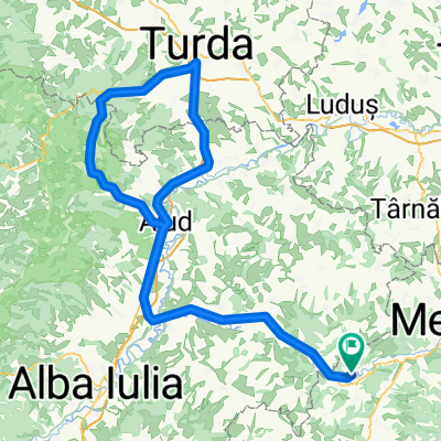
This section of the trail is rich in history, both old and recent, under whose weight important cities stretch lazily, preserving their royal and Dacian fortresses. Here, too, are the highest altitudes of Via Transilvanica (VT), reaching approximately 1,300 meters. One of the cities that Terra Dacica passes through is Alba Iulia, a place where major events such as the Great Union took place - a city that stands as a symbol of unity and national identity for Romanians. Vast vineyards, steppe-like habitats offering visitors fascinating insights into flora, fauna, paleontology, and mineralogy, small hobbit-like villages with rounded stone fences, discoveries of dwarf dinosaur fossils, traces of the Dacian ancestors, and welcoming people who always have a kind word to say - Terra Dacica is an experience like no other. More information: https://www.viatransilvanica.com/en/
- -:--
- Czas
- 293,6 km
- Dystans
- 8599 m
- Przewyższenia
- 8233 m
- Spadek
- ---
- Śr. Prędkość
- 1220 m
- Maks. wysokość

Zdjęcia trasy
”")
”")
”")
”")
”")
Kontynuuj z Bikemap
Użyj, edytuj lub pobierz tę trasę rowerową
Chcesz przejechać trasę Via Transilvanica, Section 5: Terra Dacica (official) lub dostosować ją do swojej wycieczki? Oto, co możesz zrobić z tą trasą na Bikemap:
Darmowe funkcje
- Zapisz tę trasę jako ulubioną lub w kolekcji
- Skopiuj i zaplanuj swoją wersję tej trasy
- Podziel trasę na etapy, aby utworzyć kilkudniową wycieczkę
- Synchronizuj swoją trasę z Garminem lub Wahoo
Funkcje Premium
3 dni bezpłatnej wersji próbnej lub jednorazowa opłata. Dowiedz się więcej o Bikemap Premium.
- Nawiguj po tej trasie na iOS i Androidzie
- Eksportuj plik GPX / KML tej trasy
- Stwórz swój własny wydruk (wypróbuj za darmo)
- Pobierz tę trasę do nawigacji offline
Odkryj więcej funkcji Premium.
Uzyskaj Bikemap PremiumOd naszej społeczności
Micăsasa: Inne popularne trasy rozpoczynające się tutaj
 Via Transilvanica judetul Alba
- Dystans
- 133,7 km
- Przewyższenia
- 0 m
- Spadek
- 0 m
- Lokalizacja
- Micăsasa, Okręg Sybin, Rumunia
 No 01 Micasasa - Bârghiş
- Dystans
- 170,7 km
- Przewyższenia
- 783 m
- Spadek
- 783 m
- Lokalizacja
- Micăsasa, Okręg Sybin, Rumunia
 No 02 Micasasa - Cluj Napoca
- Dystans
- 291 km
- Przewyższenia
- 1109 m
- Spadek
- 1108 m
- Lokalizacja
- Micăsasa, Okręg Sybin, Rumunia
 micasasa - cluj
- Dystans
- 123,9 km
- Przewyższenia
- 646 m
- Spadek
- 583 m
- Lokalizacja
- Micăsasa, Okręg Sybin, Rumunia
 Spring Classic Challenge
- Dystans
- 143,8 km
- Przewyższenia
- 694 m
- Spadek
- 696 m
- Lokalizacja
- Micăsasa, Okręg Sybin, Rumunia
 Spring Classic Challenge
- Dystans
- 140,4 km
- Przewyższenia
- 759 m
- Spadek
- 757 m
- Lokalizacja
- Micăsasa, Okręg Sybin, Rumunia
 No 30 Micasasa - Rimetia
- Dystans
- 194,3 km
- Przewyższenia
- 606 m
- Spadek
- 607 m
- Lokalizacja
- Micăsasa, Okręg Sybin, Rumunia
- Via Transilvanica, Section 5: Terra Dacica (official)
- Dystans
- 293,6 km
- Przewyższenia
- 8599 m
- Spadek
- 8233 m
- Lokalizacja
- Micăsasa, Okręg Sybin, Rumunia
Otwórz ją w aplikacji