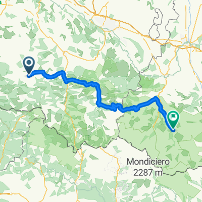
Saint-Jean-Pied-de-Port - L`Abérouat
Trasa rowerowa rozpoczynająca się w Arette, Nouvelle-Aquitaine, Francja.
Przegląd
O tej trasie
- -:--
- Czas
- 212,4 km
- Dystans
- 4981 m
- Przewyższenia
- 6274 m
- Spadek
- ---
- Śr. Prędkość
- ---
- Maks. wysokość
Jakość trasy
Typy dróg i nawierzchnie na trasie
Typy dróg
Droga
161,4 km
(76 %)
Spokojna droga
17 km
(8 %)
Niezdefiniowany
34 km
(16 %)
Powierzchnie
Utwardzona
104,1 km
(49 %)
Asfalt
104,1 km
(49 %)
Niezdefiniowany
108,3 km
(51 %)
Najważniejsze punkty trasy
Punkty zainteresowania na trasie
Interesujące miejsce po 0 km
L`Abérouat
Interesujące miejsce po 23,6 km
Col de Bouesou
Interesujące miejsce po 33,6 km
Col de Labays
Interesujące miejsce po 73,3 km
Col de la Hourcère
Interesujące miejsce po 76,7 km
Col de Sainte Gracie
Interesujące miejsce po 78,7 km
Col de Soudet
Interesujące miejsce po 80,4 km
Col de la Pierre Saint-Martin
Interesujące miejsce po 110 km
Col d`Erroymendi
Interesujące miejsce po 110,3 km
Port de Larrau
Interesujące miejsce po 117,1 km
Col d`Orgambidesca
Interesujące miejsce po 118,2 km
Col Bagargui
Interesujące miejsce po 135 km
Col de Landerre
Interesujące miejsce po 157,8 km
Col de Burdincurutcheta
Interesujące miejsce po 171,2 km
Col d'Arthaburu
Interesujące miejsce po 195,1 km
Col d`Arnosteguy
Interesujące miejsce po 199,3 km
Col d`Elhursaro
Interesujące miejsce po 200 km
Pic de Beillurti
Kontynuuj z Bikemap
Użyj, edytuj lub pobierz tę trasę rowerową
Chcesz przejechać trasę Saint-Jean-Pied-de-Port - L`Abérouat lub dostosować ją do swojej wycieczki? Oto, co możesz zrobić z tą trasą na Bikemap:
Darmowe funkcje
- Zapisz tę trasę jako ulubioną lub w kolekcji
- Skopiuj i zaplanuj swoją wersję tej trasy
- Podziel trasę na etapy, aby utworzyć kilkudniową wycieczkę
- Synchronizuj swoją trasę z Garminem lub Wahoo
Funkcje Premium
3 dni bezpłatnej wersji próbnej lub jednorazowa opłata. Dowiedz się więcej o Bikemap Premium.
- Nawiguj po tej trasie na iOS i Androidzie
- Eksportuj plik GPX / KML tej trasy
- Stwórz swój własny wydruk (wypróbuj za darmo)
- Pobierz tę trasę do nawigacji offline
Odkryj więcej funkcji Premium.
Uzyskaj Bikemap PremiumOd naszej społeczności
Arette: Inne popularne trasy rozpoczynające się tutaj
 Saint-Jean-Pied-de-Port - L`Abérouat
- Dystans
- 212,4 km
- Przewyższenia
- 4981 m
- Spadek
- 6274 m
- Lokalizacja
- Arette, Nouvelle-Aquitaine, Francja
 3 Arette - Arrens-Marsous
- Dystans
- 76,2 km
- Przewyższenia
- 2166 m
- Spadek
- 1476 m
- Lokalizacja
- Arette, Nouvelle-Aquitaine, Francja
 2. Montory - Luz-Saint-Sauveur
- Dystans
- 119,7 km
- Przewyższenia
- 2500 m
- Spadek
- 2059 m
- Lokalizacja
- Arette, Nouvelle-Aquitaine, Francja
 El Soudet desde Arette
- Dystans
- 22,7 km
- Przewyższenia
- 1311 m
- Spadek
- 17 m
- Lokalizacja
- Arette, Nouvelle-Aquitaine, Francja
 Lestelle-Bétharram - Arette La Pierre Saint-Martin
- Dystans
- 227 km
- Przewyższenia
- 3345 m
- Spadek
- 4728 m
- Lokalizacja
- Arette, Nouvelle-Aquitaine, Francja
 Escot - Artaburu
- Dystans
- 213 km
- Przewyższenia
- 4939 m
- Spadek
- 4135 m
- Lokalizacja
- Arette, Nouvelle-Aquitaine, Francja
 Trans3 vielha-luz
- Dystans
- 121,3 km
- Przewyższenia
- 1303 m
- Spadek
- 1524 m
- Lokalizacja
- Arette, Nouvelle-Aquitaine, Francja
 Tardets-Sorholus - Col d'Erroymendi - Spanien - Col de La Pierre St. Martin
- Dystans
- 116,6 km
- Przewyższenia
- 2520 m
- Spadek
- 2520 m
- Lokalizacja
- Arette, Nouvelle-Aquitaine, Francja
Otwórz ją w aplikacji


