

Frimley To Oldbury Pt2
Trasa rowerowa rozpoczynająca się w Northampton, Anglia, Zjednoczone Królestwo Wielkiej Brytanii.
Przegląd
O tej trasie
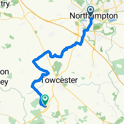
Z Travelodge w Northampton wróć do odgałęzienia Northampton Wielkiego Kanału Unii i dołącz do Wielkiego Kanału Unii, kierując się na północ.
Kontynuuj do Braunston (tuż przed Braunston znajduje się tunel, co oznacza, że musisz opuścić kanał... Prawie się tam zgubiłem, ponieważ droga powrotna nie jest oznakowana... Sprawdź na Google Maps, aby zapoznać się z trasą) i wybierz kanał Oxford na zachód. Jedź do Napton Junction i wybierz Wielki Kanał Unii na północ do Kingswood (tunel w Shrewley). Dołącz do kanału Stratford Upon Avon, kierując się na północ, aż do skrzyżowania z kanałem Worcester and Birmingham (jest też tunel tuż przed tym skrzyżowaniem, co oznacza, że trzeba opuścić kanał... znowu droga powrotna nie jest oznakowana, więc sprawdź na Google Maps). Kontynuuj na północ do Gas Street Basin. Dołącz do Birmingham Canal Navigations, jadąc na północny zachód do Birmingham Canal (stara linia główna)... jedź nim do skrzyżowania drogowego z Churchbridge.
Jedź główną drogą do Travelodge w Oldbury, B69 2BH.
- -:--
- Czas
- 115,9 km
- Dystans
- 282 m
- Przewyższenia
- 188 m
- Spadek
- ---
- Śr. Prędkość
- ---
- Maks. wysokość
Najważniejsze punkty trasy
Punkty zainteresowania na trasie
Interesujące miejsce po 28 km
Interesujące miejsce po 30,2 km
Interesujące miejsce po 69,2 km
Superb flight of 22 or more locks
Interesujące miejsce po 73,1 km
Tunnel starts here
Interesujące miejsce po 73,4 km
route continues down side of 92 Shrewley Common
Interesujące miejsce po 73,5 km
tunnel ends here
Interesujące miejsce po 78 km
join the Straford Upon Avon Canal here
Interesujące miejsce po 96,3 km
tunnel starts here
Interesujące miejsce po 96,7 km
tunnel ends here
Interesujące miejsce po 98,1 km
Worcester and Birmingham Canal
Interesujące miejsce po 109,8 km
Birmingham (old Line)
Interesujące miejsce po 113,1 km
Old Line Crosses New Line
Kontynuuj z Bikemap
Użyj, edytuj lub pobierz tę trasę rowerową
Chcesz przejechać trasę Frimley To Oldbury Pt2 lub dostosować ją do swojej wycieczki? Oto, co możesz zrobić z tą trasą na Bikemap:
Darmowe funkcje
- Zapisz tę trasę jako ulubioną lub w kolekcji
- Skopiuj i zaplanuj swoją wersję tej trasy
- Podziel trasę na etapy, aby utworzyć kilkudniową wycieczkę
- Synchronizuj swoją trasę z Garminem lub Wahoo
Funkcje Premium
3 dni bezpłatnej wersji próbnej lub jednorazowa opłata. Dowiedz się więcej o Bikemap Premium.
- Nawiguj po tej trasie na iOS i Androidzie
- Eksportuj plik GPX / KML tej trasy
- Stwórz swój własny wydruk (wypróbuj za darmo)
- Pobierz tę trasę do nawigacji offline
Odkryj więcej funkcji Premium.
Uzyskaj Bikemap PremiumOd naszej społeczności
Northampton: Inne popularne trasy rozpoczynające się tutaj
 London Road to London Road
- Dystans
- 38,2 km
- Przewyższenia
- 329 m
- Spadek
- 339 m
- Lokalizacja
- Northampton, Anglia, Zjednoczone Królestwo Wielkiej Brytanii
 Fir Fun.
- Dystans
- 18,9 km
- Przewyższenia
- 349 m
- Spadek
- 354 m
- Lokalizacja
- Northampton, Anglia, Zjednoczone Królestwo Wielkiej Brytanii
 Day 8
Day 8- Dystans
- 108 km
- Przewyższenia
- 391 m
- Spadek
- 441 m
- Lokalizacja
- Northampton, Anglia, Zjednoczone Królestwo Wielkiej Brytanii
 Frimley To Oldbury Pt2
- Dystans
- 115,9 km
- Przewyższenia
- 282 m
- Spadek
- 188 m
- Lokalizacja
- Northampton, Anglia, Zjednoczone Królestwo Wielkiej Brytanii
 Cats 11/08/10
- Dystans
- 26 km
- Przewyższenia
- 164 m
- Spadek
- 161 m
- Lokalizacja
- Northampton, Anglia, Zjednoczone Królestwo Wielkiej Brytanii
 Spinney Hill Road 63 to Spinney Hill Road 63
- Dystans
- 24,8 km
- Przewyższenia
- 193 m
- Spadek
- 193 m
- Lokalizacja
- Northampton, Anglia, Zjednoczone Królestwo Wielkiej Brytanii
 Guilsborough Long
- Dystans
- 56,3 km
- Przewyższenia
- 375 m
- Spadek
- 369 m
- Lokalizacja
- Northampton, Anglia, Zjednoczone Królestwo Wielkiej Brytanii
 Northampton to Silverstone
- Dystans
- 31 km
- Przewyższenia
- 244 m
- Spadek
- 188 m
- Lokalizacja
- Northampton, Anglia, Zjednoczone Królestwo Wielkiej Brytanii
Otwórz ją w aplikacji