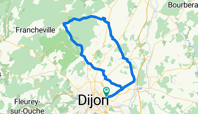

2009 Euro Tour -- Ride Day 15 — 9 July 2009 — 21850 St-Apollinaire (Dijon) to 89200 Magny (Avallon)
- 119,3 km
- 628 m
- 635 m
- Saint-Apollinaire, Burgundia-Franche-Comté, Francja
Postanowiliśmy zostać jeszcze dwie noce w Dijon, więc wybraliśmy się na świetną wycieczkę na północ od miasta. Na szczęście, pomimo pięknej prognozy pogody, zabraliśmy ze sobą kurtki i ochraniacze przeciwdeszczowe na buty, ponieważ w końcu trochę padało. Nie było to tak przemoczone jak wcześniej na tej trasie, ale wystarczająco, byśmy dość mocno się zmoczyli.
Na tej trasie długi, 9-kilometrowy podjazd pod D996 z około 300 m do 554 m był zdecydowanie dobrą sekcją treningową.
W drodze powrotnej, dzięki wiedzy zdobytej przez zgubienie się poprzedniego dnia, udało nam się łatwo znaleźć Carrefour. Umożliwiło nam to łatwy zakup jedzenia na kolację i na kilka następnych dni. Ostatniej nocy mieliśmy raczej skromną kolację w pokoju, konsumując wszystkie pozostałe zapasy jedzenia. Ponieważ przyjechaliśmy dość późno po czasie spędzonym na pedalingu wokół Dijon, nie mieliśmy czasu, by zdążyć do sklepu.
Tło:
Moja żona i ja od 1993 roku organizujemy samodzielne wycieczki po Europie Zachodniej (głównie po Francji). Ten cykl opisuje naszą trasę z 2009 roku trwającą 4,5 miesiąca przez części Francji, Niemiec, Austrii, Szwajcarii, a następnie z powrotem do Francji. Nasz punkt startowy i końcowy znajduje się niedaleko Chadurie (na południe od Angouleme), gdzie nasi przyjaciele mają farmę z Gites i Chambres d'Hôtes.
Jeździliśmy na naszych rowerach turystycznych Dawes zakupionych w 1993 roku, mocno załadowanych oponami 700Cx32. Cała nasza jazda odbywała się po asfaltowych drogach, zazwyczaj z bardzo małym ruchem. Praktycznie jedyne nieutwardzone odcinki to niektóre ścieżki rowerowe w Niemczech i Austrii. Niestety nie było to najlepsze, ponieważ Helen kilka razy spadła na nieutwardzonych ścieżkach. Na szczęście nie było poważnych obrażeń.
W razie pytań, proszę pisać na jeffkadet@netdiving.com
Jeff
Droga
21,2 km35 %Spokojna droga
10,9 km18 %Utwardzona
27,9 km(46 %)Asfalt
27,9 km46 %Niezdefiniowany
32,7 km54 %3 dni bezpłatnej wersji próbnej lub jednorazowa opłata. Dowiedz się więcej o Bikemap Premium.
Odkryj więcej funkcji Premium.
Uzyskaj Bikemap PremiumOtwórz ją w aplikacji