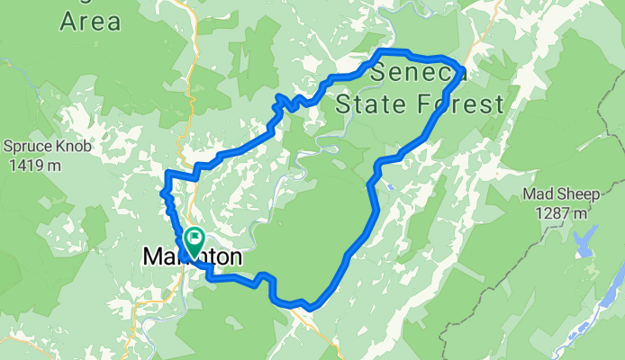
Marlinton-Cloverlick Loop
Trasa rowerowa rozpoczynająca się w Marlinton, Wirginia Zachodnia, USA.
Przegląd
O tej trasie
To świetna pętla z różnorodnymi wyzwaniami rowerowymi. Pierwsza część to wąskie drogi wiejskie z wieloma podjazdami i zjazdami oraz licznymi krótkimi, stromymi wzniesieniami. Druga połowa przebiega dwupasmowymi drogami, głównie zjazdem, co umożliwia szybkie powroty do Marlinton. Ostatnie 6 mil od Huntersville do Marlinton to zazwyczaj jedyny odcinek, na którym możesz napotkać problemy z ruchem.
Zwykle zaczynam tę wycieczkę w Edray ze względu na pobliskie miejsce na camping, ale podam listę skrętów od centrum Marlinton. Wody można nabrać przy miejscu piknikowym lub w biurze Seneca State Forest.
0.0 Centrum Marlinton na skrzyżowaniu z Greenbrier River Trail.
0.3 W lewo na Rt. 39 na końcu mostu.
0.5 W prawo na Jericho Road<br />
4.3 W lewo - całkowicie w lewo, by kontynuować na Jericho Rd.
4.9 W prawo na Co. Rt. 17 Woodrow Road
6.0 W lewo na Rt 219 w Edray. Ostatni sklep na trasie.
6.2 W prawo na Back Mt. Road obok kościoła. Kontynuuj Back Mt. Road aż do Cloverlick.<br />
11.8 Pętla
16.7 Prosto na skrzyżowaniu w Cloverlick na Laurel Run Rd. 1/4 i przejazd przez Greenbrier River. Back Mt. Road tu skręca w lewo w kierunku Cass.
21.0 W prawo na State 28.
33.8 W prawo na St. 39.
39.0 Meta<br />
- -:--
- Czas
- 62,8 km
- Dystans
- 537 m
- Przewyższenia
- 537 m
- Spadek
- ---
- Śr. Prędkość
- ---
- Maks. wysokość
Jakość trasy
Typy dróg i nawierzchnie na trasie
Typy dróg
Droga
31,4 km
(50 %)
Spokojna droga
1,3 km
(2 %)
Niezdefiniowany
30,2 km
(48 %)
Powierzchnie
Utwardzona
33,9 km
(54 %)
Nawierzchnia (nieokreślona)
19,5 km
(31 %)
Asfalt
14,5 km
(23 %)
Niezdefiniowany
28,9 km
(46 %)
Kontynuuj z Bikemap
Użyj, edytuj lub pobierz tę trasę rowerową
Chcesz przejechać trasę Marlinton-Cloverlick Loop lub dostosować ją do swojej wycieczki? Oto, co możesz zrobić z tą trasą na Bikemap:
Darmowe funkcje
- Zapisz tę trasę jako ulubioną lub w kolekcji
- Skopiuj i zaplanuj swoją wersję tej trasy
- Synchronizuj swoją trasę z Garminem lub Wahoo
Funkcje Premium
3 dni bezpłatnej wersji próbnej lub jednorazowa opłata. Dowiedz się więcej o Bikemap Premium.
- Nawiguj po tej trasie na iOS i Androidzie
- Eksportuj plik GPX / KML tej trasy
- Stwórz swój własny wydruk (wypróbuj za darmo)
- Pobierz tę trasę do nawigacji offline
Odkryj więcej funkcji Premium.
Uzyskaj Bikemap PremiumOd naszej społeczności
Marlinton: Inne popularne trasy rozpoczynające się tutaj
 Assault on Droop Mountain - Mountain State Wheelers
- Dystans
- 74,8 km
- Przewyższenia
- 1016 m
- Spadek
- 1016 m
- Lokalizacja
- Marlinton, Wirginia Zachodnia, USA
 Clover Lick - Green Bank
- Dystans
- 50,3 km
- Przewyższenia
- 546 m
- Spadek
- 546 m
- Lokalizacja
- Marlinton, Wirginia Zachodnia, USA
 Three-Mountain Ride CLONED FROM ROUTE 216425
- Dystans
- 110,7 km
- Przewyższenia
- 1909 m
- Spadek
- 1711 m
- Lokalizacja
- Marlinton, Wirginia Zachodnia, USA
 Assault on Droop Mountain
- Dystans
- 73,7 km
- Przewyższenia
- 1053 m
- Spadek
- 1053 m
- Lokalizacja
- Marlinton, Wirginia Zachodnia, USA
 Hillsboro - Droop - Locust Creek Loop
- Dystans
- 28,6 km
- Przewyższenia
- 421 m
- Spadek
- 421 m
- Lokalizacja
- Marlinton, Wirginia Zachodnia, USA
 Marlinton-Cloverlick Loop
- Dystans
- 62,8 km
- Przewyższenia
- 537 m
- Spadek
- 537 m
- Lokalizacja
- Marlinton, Wirginia Zachodnia, USA
 Hillsboro-Lobelia Loop
- Dystans
- 28,7 km
- Przewyższenia
- 571 m
- Spadek
- 571 m
- Lokalizacja
- Marlinton, Wirginia Zachodnia, USA
 Clover Lick - Observatory Route
- Dystans
- 64,9 km
- Przewyższenia
- 552 m
- Spadek
- 555 m
- Lokalizacja
- Marlinton, Wirginia Zachodnia, USA
Otwórz ją w aplikacji


