
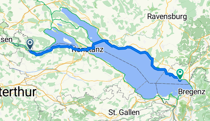

Bodensee-Radmarathon 08 Etappe 6 Posten Stein am Rhein bis zur Faehre
- 50,9 km
- 176 m
- 183 m
- Stein am Rhein, Szafuza, Szwajcaria
Trasa rowerowa rozpoczynająca się w Stein am Rhein, Szafuza, Szwajcaria.
Przegląd
utworzono 10 miesięcy temu temu

Jakość trasy
Spokojna droga
27,8 km
32 %
Ścieżka
16,5 km
19 %
Utwardzona
69,4 km
(80 %)
Nieutwardzona
8,7 km
(10 %)
Asfalt
69,4 km
80 %
Luźny żwir
3,5 km
4 %
Najważniejsze punkty trasy
Wallfahrtskapelle St. Otmar
Viewpoint
Museum im Turmhof local history museum
Cathedral
Rheintorturm The Rheintorturm, built in 1200, rises above the Rhine next to the Rhine Bridge. In former times, the old Rhine bridge passed through it, then it was moved a hundred meters higher, so the tower today looks a little out of context. In addition to its defensive function, the tower and bridge were an important transport hub of the medieval city. Historians claim that Frederick II passed through the gates of the tower during his visits to the city, as well as other crowned heads. The tower and bridge were heavily damaged during the Napoleonic Wars. It was reconstructed several times, a thorough reconstruction took place in 1999. Now the tower is used as an observation deck. You need to climb the steps and enjoy a beautiful view of the Rhine River and the surrounding city. From the Rheintorturm you can walk along the embankment to the next tower, although not so impressive from the outside.
Mainau Flower Island and Castle no bikes €26
Ferry https://www.bsb.de/sites/default/files/2024-11/Fahrplan-2025-Web_0.pdf every 15 min to Meersberg. Other departures as far as Lindau...
Meersburg Castle Burg Meersburg
Zeppelin Museum Meersburg
Meersburg Altstadt
Schloßplatz
Schloss Kirchberg
Schlosskirche Evangelical church
Schloss Friedrichshafen 2-6pm
Schlosssteg
Zeppelin Museum Friedrichshafen 9-5
Historische Holzbrücke Eriskirch wooden bridge
Schloss Montfort | Turmbesteigung 10-5
Malerwinkel viewpoint
Schloss Wasserburg
St. Georg church
Pulverturm viewpoint built as an old city watch tower than converted to powder supply room in 18th century. then the mayor lived in it and wrote memories and host famous guests from the golden age of industry in germany. closed to public views
Mangturm This distinctive 1100s structure hosts seasonal story-telling events based on classic fairy tales.
Altes Rathaus Gothic-era, gabled former city hall from 1422, fronted by a wooden galley & decorative murals.
Kontynuuj z Bikemap
Chcesz przejechać trasę Stein am Rhein to Lindau lub dostosować ją do swojej wycieczki? Oto, co możesz zrobić z tą trasą na Bikemap:
3 dni bezpłatnej wersji próbnej lub jednorazowa opłata. Dowiedz się więcej o Bikemap Premium.
Odkryj więcej funkcji Premium.
Uzyskaj Bikemap PremiumOd naszej społeczności
Otwórz ją w aplikacji


