

Star Cycles Inglewood-COP-Kersbrook
Trasa rowerowa rozpoczynająca się w Elizabeth, State of South Australia, Australia.
Przegląd
O tej trasie
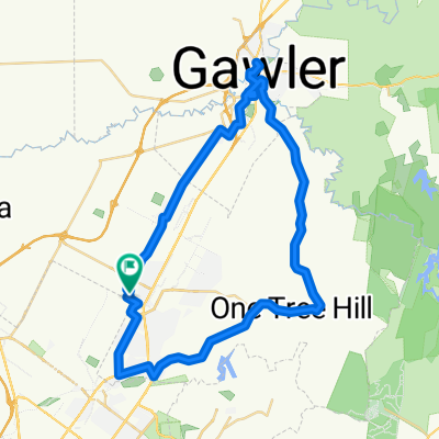
Opuszczamy Star Cycles przez Elizabeth Way i Philip Hwy do John Rice Av. Skręcamy w prawo w Commercial Rd, a następnie w lewo, co prowadzi nas przez Salisbury obok Parabanks. Skręć w lewo w Ponton St, ponownie w lewo w Fenden Rd, która prowadzi na Saints Rd. Przekrocz Main North Rd i jedź w górę Grove Way, który staje się Yatala Vale Rd. Kontynuuj aż do Seaview Rd, gdzie skręt w lewo prowadzi nas na Range Rd North. Umiarkone wzniesienie prowadzi nas do Lower North East Rd, gdzie skręt w lewo prowadzi naszą grupę przez Inglewood, Chain of Ponds i Kersbrook. Nasz postój na odświeżenie w tym tygodniu jest w Kersbrook Hill Winery. Kawa i muffinka 5 $. Skręt w lewo w Kersbrook przedstawia rowerzystom długie podjazdy w kierunku One Tree Hill, a po pokonaniu szczytu ciesz się długim, szybkim zjazdem. Zwolnij na skrzyżowaniu na dole i skręć w lewo, potem w prawo do One Tree Hill. Kontynuuj na Yorktown Rd, skręć w prawo i znowu zjedź w dół do Star Cycles przez Ifould Rd i Winterslow Rd.
- -:--
- Czas
- 64 km
- Dystans
- 717 m
- Przewyższenia
- 717 m
- Spadek
- ---
- Śr. Prędkość
- ---
- Maks. wysokość
Jakość trasy
Typy dróg i nawierzchnie na trasie
Typy dróg
Droga
9 km
(14 %)
Spokojna droga
4,5 km
(7 %)
Powierzchnie
Utwardzona
54,4 km
(85 %)
Nieutwardzona
3,2 km
(5 %)
Asfalt
44,8 km
(70 %)
Nawierzchnia (nieokreślona)
9,6 km
(15 %)
Najważniejsze punkty trasy
Punkty zainteresowania na trasie
Interesujące miejsce po 39,4 km
kersbrook winery - coffee
Kontynuuj z Bikemap
Użyj, edytuj lub pobierz tę trasę rowerową
Chcesz przejechać trasę Star Cycles Inglewood-COP-Kersbrook lub dostosować ją do swojej wycieczki? Oto, co możesz zrobić z tą trasą na Bikemap:
Darmowe funkcje
- Zapisz tę trasę jako ulubioną lub w kolekcji
- Skopiuj i zaplanuj swoją wersję tej trasy
- Synchronizuj swoją trasę z Garminem lub Wahoo
Funkcje Premium
3 dni bezpłatnej wersji próbnej lub jednorazowa opłata. Dowiedz się więcej o Bikemap Premium.
- Nawiguj po tej trasie na iOS i Androidzie
- Eksportuj plik GPX / KML tej trasy
- Stwórz swój własny wydruk (wypróbuj za darmo)
- Pobierz tę trasę do nawigacji offline
Odkryj więcej funkcji Premium.
Uzyskaj Bikemap PremiumOd naszej społeczności
Elizabeth: Inne popularne trasy rozpoczynające się tutaj
 Yorktown Road 32, Elizabeth East to McCormack Crescent 50, Salisbury North
- Dystans
- 20,9 km
- Przewyższenia
- 255 m
- Spadek
- 285 m
- Lokalizacja
- Elizabeth, State of South Australia, Australia
 One Tree Hill Scenic route Gawler
- Dystans
- 57,1 km
- Przewyższenia
- 330 m
- Spadek
- 330 m
- Lokalizacja
- Elizabeth, State of South Australia, Australia
 Angaston to Handorf
- Dystans
- 234,1 km
- Przewyższenia
- 1334 m
- Spadek
- 1333 m
- Lokalizacja
- Elizabeth, State of South Australia, Australia
 Elizabeth East to Hilton South Australia
- Dystans
- 30,5 km
- Przewyższenia
- 48 m
- Spadek
- 91 m
- Lokalizacja
- Elizabeth, State of South Australia, Australia
 1/1 ride
- Dystans
- 47,6 km
- Przewyższenia
- 1467 m
- Spadek
- 1465 m
- Lokalizacja
- Elizabeth, State of South Australia, Australia
 Star Cycles - Sandy Creek - hillier rd
- Dystans
- 59,8 km
- Przewyższenia
- 196 m
- Spadek
- 196 m
- Lokalizacja
- Elizabeth, State of South Australia, Australia
 trip...
- Dystans
- 11,6 km
- Przewyższenia
- 25 m
- Spadek
- 56 m
- Lokalizacja
- Elizabeth, State of South Australia, Australia
 Little Para River Trl, Salisbury Park to 12 Main St, Mawson Lakes
- Dystans
- 12,3 km
- Przewyższenia
- 30 m
- Spadek
- 70 m
- Lokalizacja
- Elizabeth, State of South Australia, Australia
Otwórz ją w aplikacji