

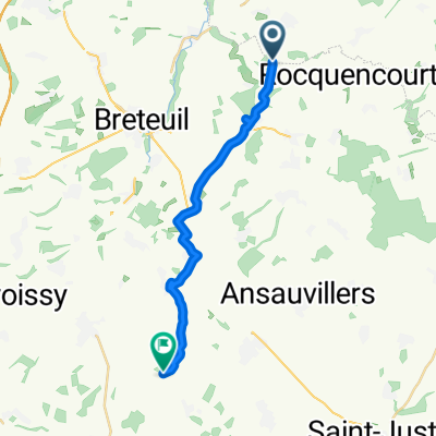
2009 Euro Tour -- Ride Day 23 — 19 July 2009 — 60120 Breteuil-sur-Noye to 02000 Laon
Trasa rowerowa rozpoczynająca się w Breteuil, Hauts-de-France, Francja.
Przegląd
O tej trasie
Świetna jazda, znów z wiatrem w plecy i z szybko przesuwającymi się chmurami, z których każda mogłaby się na nas wylać. Na szczęście, żadna z nich tego nie zrobiła. Na długo zapamiętamy wjazd i wyjazd ze St Gobain na D7. Po przejechaniu znaku, który wskazywał, że wjechaliśmy do miasta, mieliśmy długą, strome podjazd, aby wjechać i opuścić miasteczko. Podczas dnia przeszliśmy z departamentu Oise i przez chwilę przejechaliśmy przez departament Somme, zanim wróciliśmy z powrotem do departamentu Oise. Później przeszliśmy do departamentu Aisne. Wszystkie te departamenty znajdują się w regionie Pikardia.
Tło: Moja żona i ja od 1993 roku organizujemy wycieczki wspierane samodzielnie w zachodniej Europie (większość w Francji). Ta seria przejażdżek obejmuję naszą trasę z 2009 roku przez część Francji, Niemiec, Austrii, Szwajcarii, a następnie z powrotem do Francji. Naszym punktem początkowym i końcowym jest w pobliżu Chadurie (na południe od Angoulême), gdzie nasi przyjaciele mają farmę z Gîtes i Chambres d'Hôtes.
Jeździliśmy na naszych rowerach turystycznych Dawes zakupionych w 1993 roku, mocno załadowanych oponami 700Cx32. Wszystkie nasze przejażdżki odbywały się na asfaltowych drogach, głównie z bardzo małym ruchem. Praktycznie jedynymi nieutwardzonymi odcinkami były niektóre ścieżki rowerowe w Niemczech i Austrii. Niestety, to nie było takie wspaniałe, ponieważ Helen kilka razy upadła na nieutwardzonych ścieżkach. Na szczęście jednak, nie było żadnych poważnych obrażeń.
- -:--
- Czas
- 110 km
- Dystans
- 390 m
- Przewyższenia
- 418 m
- Spadek
- ---
- Śr. Prędkość
- ---
- Maks. wysokość

Jakość trasy
Typy dróg i nawierzchnie na trasie
Typy dróg
Droga
26,4 km
(24 %)
Spokojna droga
9,9 km
(9 %)
Powierzchnie
Utwardzona
38,5 km
(35 %)
Asfalt
38,5 km
(35 %)
Niezdefiniowany
71,5 km
(65 %)
Kontynuuj z Bikemap
Użyj, edytuj lub pobierz tę trasę rowerową
Chcesz przejechać trasę 2009 Euro Tour -- Ride Day 23 — 19 July 2009 — 60120 Breteuil-sur-Noye to 02000 Laon lub dostosować ją do swojej wycieczki? Oto, co możesz zrobić z tą trasą na Bikemap:
Darmowe funkcje
- Zapisz tę trasę jako ulubioną lub w kolekcji
- Skopiuj i zaplanuj swoją wersję tej trasy
- Podziel trasę na etapy, aby utworzyć kilkudniową wycieczkę
- Synchronizuj swoją trasę z Garminem lub Wahoo
Funkcje Premium
3 dni bezpłatnej wersji próbnej lub jednorazowa opłata. Dowiedz się więcej o Bikemap Premium.
- Nawiguj po tej trasie na iOS i Androidzie
- Eksportuj plik GPX / KML tej trasy
- Stwórz swój własny wydruk (wypróbuj za darmo)
- Pobierz tę trasę do nawigacji offline
Odkryj więcej funkcji Premium.
Uzyskaj Bikemap PremiumOd naszej społeczności
Breteuil: Inne popularne trasy rozpoczynające się tutaj
 Tour des collègues
- Dystans
- 30,2 km
- Przewyższenia
- 294 m
- Spadek
- 294 m
- Lokalizacja
- Breteuil, Hauts-de-France, Francja
 Easy ride in Quiry-le-Sec
- Dystans
- 18,2 km
- Przewyższenia
- 149 m
- Spadek
- 108 m
- Lokalizacja
- Breteuil, Hauts-de-France, Francja
 De Rue du Frêne 25, Hardivillers à Rue du Sac 14, Cormeilles
- Dystans
- 31,4 km
- Przewyższenia
- 383 m
- Spadek
- 400 m
- Lokalizacja
- Breteuil, Hauts-de-France, Francja
 11–13 Rue Saint-Vincent de Paul, Folleville à 14 Rue de l'École, Quiry-le-Sec
- Dystans
- 1,6 km
- Przewyższenia
- 13 m
- Spadek
- 3 m
- Lokalizacja
- Breteuil, Hauts-de-France, Francja
 Fremontiers Grand Tour
- Dystans
- 54,8 km
- Przewyższenia
- 552 m
- Spadek
- 552 m
- Lokalizacja
- Breteuil, Hauts-de-France, Francja
 La vallée Viton
- Dystans
- 2,3 km
- Przewyższenia
- 0 m
- Spadek
- 50 m
- Lokalizacja
- Breteuil, Hauts-de-France, Francja
 2004 ツール観戦記 第5ステージ 走行ルート
- Dystans
- 233,7 km
- Przewyższenia
- 662 m
- Spadek
- 592 m
- Lokalizacja
- Breteuil, Hauts-de-France, Francja
 La descente de la route blanche
- Dystans
- 2,7 km
- Przewyższenia
- 0 m
- Spadek
- 44 m
- Lokalizacja
- Breteuil, Hauts-de-France, Francja
Otwórz ją w aplikacji