
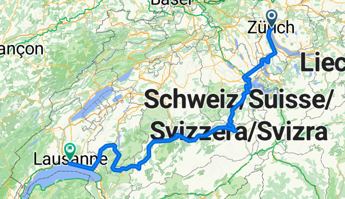
Lakes Route - Zurich to Lausanne
Trasa rowerowa rozpoczynająca się w Zürich (Kreis 6) / Oberstrass, Zurych, Szwajcaria.
Przegląd
O tej trasie
Więcej o Lakes Route: https://www.cyclingthread.com/exploring-swiss-alps-cycling-lakes-route-in-switzerland Lakes Route to około 500-kilometrowa trasa rowerowa przez pocztówkową Szwajcarię, łącząca dziesięć malowniczych jezior i regionów, takich jak Werdenberg, Lucerna u stóp góry Pilatus, Iseltwald nad Jeziorem Brienz, Gruyères oraz winnice Lavaux nad Jeziorem Genewskim. Opisywana wersja zaczyna się w Zurychu i kończy w Lozannie, prowadząc przez Zug, Lucernę, Meiringen, Interlaken, Spiez i Gstaad. Według Switzerland Mobility trasa ma około 510 km długości z sumą przewyższeń około 5900 m. Oferuje znakomite widoki na alpejskie jeziora, urokliwe miasteczka i doliny, dlatego nadaje się idealnie na podróż wielodniową. Wielu rowerzystów planuje 6 do 8 dni na pokonanie trasy, w zależności od tempa i postojów. Jej wymagający profil z podjazdami i zjazdami czyni ją zarówno trudną, jak i satysfakcjonującą. Podsumowując, Lakes Route to dobrze zorganizowana i malownicza rowerowa przygoda, która ukazuje różnorodność szwajcarskich krajobrazów.
- 23 h 31 min
- Czas
- 341,3 km
- Dystans
- 5957 m
- Przewyższenia
- 5992 m
- Spadek
- 14,5 km/h
- Śr. Prędkość
- 1285 m
- Maks. wysokość

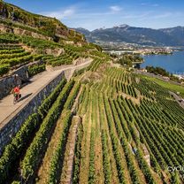
Zdjęcia trasy


Kontynuuj z Bikemap
Użyj, edytuj lub pobierz tę trasę rowerową
Chcesz przejechać trasę Lakes Route - Zurich to Lausanne lub dostosować ją do swojej wycieczki? Oto, co możesz zrobić z tą trasą na Bikemap:
Darmowe funkcje
- Zapisz tę trasę jako ulubioną lub w kolekcji
- Skopiuj i zaplanuj swoją wersję tej trasy
- Podziel trasę na etapy, aby utworzyć kilkudniową wycieczkę
- Synchronizuj swoją trasę z Garminem lub Wahoo
Funkcje Premium
3 dni bezpłatnej wersji próbnej lub jednorazowa opłata. Dowiedz się więcej o Bikemap Premium.
- Nawiguj po tej trasie na iOS i Androidzie
- Eksportuj plik GPX / KML tej trasy
- Stwórz swój własny wydruk (wypróbuj za darmo)
- Pobierz tę trasę do nawigacji offline
Odkryj więcej funkcji Premium.
Uzyskaj Bikemap PremiumOd naszej społeczności
Zürich (Kreis 6) / Oberstrass: Inne popularne trasy rozpoczynające się tutaj
 Day 1 - Zurich to Walenstadt
- Dystans
- 85,9 km
- Przewyższenia
- 194 m
- Spadek
- 226 m
- Lokalizacja
- Zürich (Kreis 6) / Oberstrass, Zurych, Szwajcaria
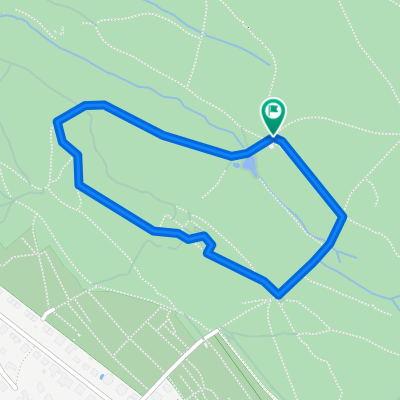 Bike-Parcour
- Dystans
- 1,4 km
- Przewyższenia
- 39 m
- Spadek
- 39 m
- Lokalizacja
- Zürich (Kreis 6) / Oberstrass, Zurych, Szwajcaria
 PrepRound
- Dystans
- 30,3 km
- Przewyższenia
- 511 m
- Spadek
- 509 m
- Lokalizacja
- Zürich (Kreis 6) / Oberstrass, Zurych, Szwajcaria
 Ausfahrt durch Zürich
- Dystans
- 15,6 km
- Przewyższenia
- 283 m
- Spadek
- 311 m
- Lokalizacja
- Zürich (Kreis 6) / Oberstrass, Zurych, Szwajcaria
 Giro ASVZ
- Dystans
- 88,9 km
- Przewyższenia
- 898 m
- Spadek
- 898 m
- Lokalizacja
- Zürich (Kreis 6) / Oberstrass, Zurych, Szwajcaria
 Greifenseerunde
- Dystans
- 45,6 km
- Przewyższenia
- 410 m
- Spadek
- 410 m
- Lokalizacja
- Zürich (Kreis 6) / Oberstrass, Zurych, Szwajcaria
 Lakes Route - Zurich to Lausanne
- Dystans
- 341,3 km
- Przewyższenia
- 5957 m
- Spadek
- 5992 m
- Lokalizacja
- Zürich (Kreis 6) / Oberstrass, Zurych, Szwajcaria
 Runde über Lieli - Hedingen - Zürich
- Dystans
- 54 km
- Przewyższenia
- 647 m
- Spadek
- 644 m
- Lokalizacja
- Zürich (Kreis 6) / Oberstrass, Zurych, Szwajcaria
Otwórz ją w aplikacji