
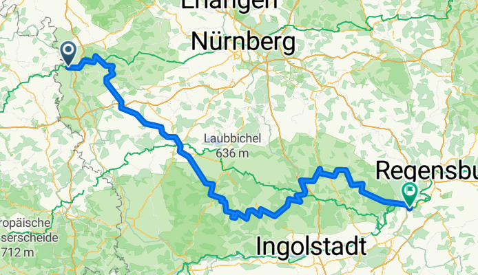
Tauber-Altmühl Cycle Route - Rothenburg ob der Tauber to Kelheim
Trasa rowerowa rozpoczynająca się w Rothenburg upon Tauber, Bavaria, Germany.
Przegląd
O tej trasie
More about the Tauber-Altmühl Radweg:
https://www.cyclingthread.com/franconia-and-tauber-altmuhl-radweg-perfect-german-getaway
The Tauber-Altmühl Radweg in Franconia is one of the most fascinating cycling routes in Germany, running through the valleys of the Tauber and Altmühl rivers and the rocky landscapes of the Franconian Jura. Its romantic atmosphere is enhanced by medieval towns, with Rothenburg ob der Tauber standing out as one of the country’s main attractions. The route begins in Wertheim, passes through Rothenburg, and after crossing the European watershed follows the Altmühl to Kelheim, where the river meets the Danube. The Tauber section is about 100 km long, while the Altmühl adds around 250 km, offering varied experiences. Surfaces range from smooth asphalt to gravel paths that fit well into the Jura scenery, even if they are less comfortable. Along the way cyclists can see geological formations like Burgstein, historic bridges in Ornbau, and the Jura Museum in Willibaldsburg Castle in Eichstätt. Altogether, the route combines landscapes, history and good infrastructure, making it an excellent choice for a long weekend or a longer cycling holiday in Franconia.
- 15 h 43 min
- Czas
- 252,2 km
- Dystans
- 1118 m
- Przewyższenia
- 1200 m
- Spadek
- 16 km/h
- Śr. Prędkość
- 510 m
- Maks. wysokość

Zdjęcia trasy


Kontynuuj z Bikemap
Użyj, edytuj lub pobierz tę trasę rowerową
Chcesz przejechać trasę Tauber-Altmühl Cycle Route - Rothenburg ob der Tauber to Kelheim lub dostosować ją do swojej wycieczki? Oto, co możesz zrobić z tą trasą na Bikemap:
Darmowe funkcje
- Zapisz tę trasę jako ulubioną lub w kolekcji
- Skopiuj i zaplanuj swoją wersję tej trasy
- Podziel trasę na etapy, aby utworzyć kilkudniową wycieczkę
- Synchronizuj swoją trasę z Garminem lub Wahoo
Funkcje Premium
3 dni bezpłatnej wersji próbnej lub jednorazowa opłata. Dowiedz się więcej o Bikemap Premium.
- Nawiguj po tej trasie na iOS i Androidzie
- Eksportuj plik GPX / KML tej trasy
- Stwórz swój własny wydruk (wypróbuj za darmo)
- Pobierz tę trasę do nawigacji offline
Odkryj więcej funkcji Premium.
Uzyskaj Bikemap PremiumOd naszej społeczności
Rothenburg upon Tauber: Inne popularne trasy rozpoczynające się tutaj
 Altmühlradweg: Rothenburg-Kelheim
- Dystans
- 244,8 km
- Przewyższenia
- 316 m
- Spadek
- 400 m
- Lokalizacja
- Rothenburg upon Tauber, Bavaria, Germany
 Rothenburg Burgbernheim Runde
- Dystans
- 30,5 km
- Przewyższenia
- 266 m
- Spadek
- 275 m
- Lokalizacja
- Rothenburg upon Tauber, Bavaria, Germany
 Rothenburg to Bamberg
- Dystans
- 120,8 km
- Przewyższenia
- 98 m
- Spadek
- 285 m
- Lokalizacja
- Rothenburg upon Tauber, Bavaria, Germany
 Paneuropa radweg (alternative german part)
- Dystans
- 36 km
- Przewyższenia
- 498 m
- Spadek
- 580 m
- Lokalizacja
- Rothenburg upon Tauber, Bavaria, Germany
 Rothenburg-Tauberquelle
- Dystans
- 44,7 km
- Przewyższenia
- 278 m
- Spadek
- 278 m
- Lokalizacja
- Rothenburg upon Tauber, Bavaria, Germany
 Rund um Rothenburg
- Dystans
- 23,1 km
- Przewyższenia
- 463 m
- Spadek
- 445 m
- Lokalizacja
- Rothenburg upon Tauber, Bavaria, Germany
 altmühltal
- Dystans
- 137,4 km
- Przewyższenia
- 496 m
- Spadek
- 540 m
- Lokalizacja
- Rothenburg upon Tauber, Bavaria, Germany
 Taubertal-Panorama
- Dystans
- 52,4 km
- Przewyższenia
- 733 m
- Spadek
- 895 m
- Lokalizacja
- Rothenburg upon Tauber, Bavaria, Germany
Otwórz ją w aplikacji