
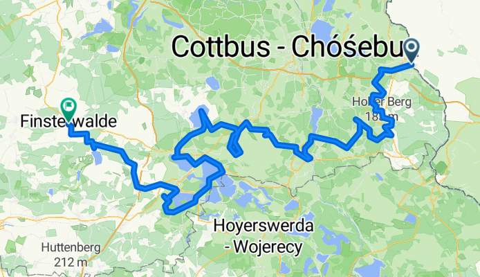
Lower Lusatia Mining Route - Forst to Finsterwalde
Trasa rowerowa rozpoczynająca się w Brody, województwo lubuskie, Polska.
Przegląd
O tej trasie
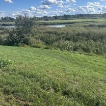
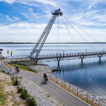
Pojezierze Łużyckie na południu Brandenburgii to dawna okolica wydobycia węgla brunatnego, która jest teraz przekształcana w region turystyczny z sztucznymi jeziorami i nowymi trasami rowerowymi. W centrum leży Szlak górniczy Dolnej Łużycy, pętla rowerowa o długości ponad 400 kilometrów, przebiegająca przez krajobrazy niegdyś zdominowane przez odkrywki. Trasa łączy miejscowości takie jak Forst, Spremberg, Großräschener See, Senftenberg i Finsterwalde, a odcinek pokonany w maju miał około 200 kilometrów. Po drodze rowerzyści zobaczą mieszankę dziedzictwa przemysłowego i nowej przyrody, od gigantycznych maszyn górniczych jak przenośnik F60 po nowoczesne punkty widokowe, takie jak wieża 'Rusty Nail'. Są też unikalne przystanki, w tym ogród różany w Forst, dawna cegielnia i manufaktura czekolady. Połączenia kolejowe czynią wyjazd elastycznym, z pociągami regionalnymi łączącymi miejsca takie jak Finsterwalde i Forst. Ogólnie Szlak górniczy Dolnej Łużycy oferuje wyjątkowe doświadczenie, pokazując jak krajobraz górniczy może stać się regionem jeziornym do jazdy na rowerze i wypoczynku.
- 12 h 16 min
- Czas
- 194,7 km
- Dystans
- 1210 m
- Przewyższenia
- 1177 m
- Spadek
- 15,9 km/h
- Śr. Prędkość
- 176 m
- Maks. wysokość

Zdjęcia trasy


Kontynuuj z Bikemap
Użyj, edytuj lub pobierz tę trasę rowerową
Chcesz przejechać trasę Lower Lusatia Mining Route - Forst to Finsterwalde lub dostosować ją do swojej wycieczki? Oto, co możesz zrobić z tą trasą na Bikemap:
Darmowe funkcje
- Zapisz tę trasę jako ulubioną lub w kolekcji
- Skopiuj i zaplanuj swoją wersję tej trasy
- Podziel trasę na etapy, aby utworzyć kilkudniową wycieczkę
- Synchronizuj swoją trasę z Garminem lub Wahoo
Funkcje Premium
3 dni bezpłatnej wersji próbnej lub jednorazowa opłata. Dowiedz się więcej o Bikemap Premium.
- Nawiguj po tej trasie na iOS i Androidzie
- Eksportuj plik GPX / KML tej trasy
- Stwórz swój własny wydruk (wypróbuj za darmo)
- Pobierz tę trasę do nawigacji offline
Odkryj więcej funkcji Premium.
Uzyskaj Bikemap PremiumOd naszej społeczności
Brody: Inne popularne trasy rozpoczynające się tutaj
 Skater Strecke Forst / Lausitz-Briesnig und zurück zum Startpunkt
- Dystans
- 22,7 km
- Przewyższenia
- 32 m
- Spadek
- 33 m
- Lokalizacja
- Brody, województwo lubuskie, Polska
 pl Zamkowy, Brody do Orła Białego, Kostrzyn nad Odrą
- Dystans
- 141,3 km
- Przewyższenia
- 305 m
- Spadek
- 348 m
- Lokalizacja
- Brody, województwo lubuskie, Polska
 Oder-Neiße Part 2
- Dystans
- 77,5 km
- Przewyższenia
- 80 m
- Spadek
- 129 m
- Lokalizacja
- Brody, województwo lubuskie, Polska
 Lower Lusatia Mining Route - Forst to Finsterwalde
- Dystans
- 194,7 km
- Przewyższenia
- 1210 m
- Spadek
- 1177 m
- Lokalizacja
- Brody, województwo lubuskie, Polska
 Berlin - Prag Etappe 03 Brody - Klein Priebus
- Dystans
- 49,3 km
- Przewyższenia
- 220 m
- Spadek
- 164 m
- Lokalizacja
- Brody, województwo lubuskie, Polska
 strzegów-forst-Gubin-strzegów CLONED FROM ROUTE 1417232
- Dystans
- 58,8 km
- Przewyższenia
- 120 m
- Spadek
- 118 m
- Lokalizacja
- Brody, województwo lubuskie, Polska
 2012-10-18 Forst-Eisenhüttenstadt
- Dystans
- 130,6 km
- Przewyższenia
- 100 m
- Spadek
- 101 m
- Lokalizacja
- Brody, województwo lubuskie, Polska
 Forst, Rosengarten, Forst (Lausitz) nach Hainstraße 6, Cottbus
- Dystans
- 31 km
- Przewyższenia
- 112 m
- Spadek
- 115 m
- Lokalizacja
- Brody, województwo lubuskie, Polska
Otwórz ją w aplikacji