

04 Aug 2012 Châteauguay valley +
Trasa rowerowa rozpoczynająca się w Sainte-Anne-de-Bellevue, Québec, Kanada.
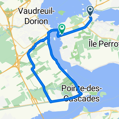
Przegląd
O tej trasie
Wycieczka jednodniowa zrealizowana 4 sierpnia 2012Całkowita długość rzeczywistej wycieczki wyniosła prawdopodobnie około 138 km (około 86 mil), ponieważ około 10 km to była przejażdżka promem z Lachine do Châteauguay, a autostop przez most do Valleyfield pokrył około 2 km.
Ogólnie rzecz biorąc, dość płaska.
- -:--
- Czas
- 150,1 km
- Dystans
- 88 m
- Przewyższenia
- 88 m
- Spadek
- ---
- Śr. Prędkość
- ---
- Maks. wysokość
Najważniejsze punkty trasy
Punkty zainteresowania na trasie
Interesujące miejsce po 27 km
Interesujące miejsce po 52,3 km
Interesujące miejsce po 55 km
Start of gravel bike path, on old railroad grade
Interesujące miejsce po 56,2 km
Bike trail as of today has an overpass built over future Auroroute 30, but it is closed to traffic, the trail crosses the 30 at ground level, which is fine for now since the highway hasn't been opened yet, but unless one has a mountain bike one has to walk the bike maybe 50 m (150-200 ft)
Interesujące miejsce po 61,4 km
Bike path now paved
Interesujące miejsce po 63,7 km
Oops, went the wrong way and had to come back, trail directions poorly indicated.
Interesujące miejsce po 66,8 km
Bike path continues paved
Interesujące miejsce po 103,7 km
Bridge cannot be crossed on a bicycle, hitchhiked across
Interesujące miejsce po 105,7 km
Dropped off here, 17:20
Interesujące miejsce po 128,2 km
Former source of cold water, no longer functional
Interesujące miejsce po 131,9 km
Construction over a short distance, walk with road bike, probably passable with hybrid or mountain bike.
Interesujące miejsce po 150,1 km
Departure, 09:00
Interesujące miejsce po 150,1 km
Finish ~20:45
Kontynuuj z Bikemap
Użyj, edytuj lub pobierz tę trasę rowerową
Chcesz przejechać trasę 04 Aug 2012 Châteauguay valley + lub dostosować ją do swojej wycieczki? Oto, co możesz zrobić z tą trasą na Bikemap:
Darmowe funkcje
- Zapisz tę trasę jako ulubioną lub w kolekcji
- Skopiuj i zaplanuj swoją wersję tej trasy
- Podziel trasę na etapy, aby utworzyć kilkudniową wycieczkę
- Synchronizuj swoją trasę z Garminem lub Wahoo
Funkcje Premium
3 dni bezpłatnej wersji próbnej lub jednorazowa opłata. Dowiedz się więcej o Bikemap Premium.
- Nawiguj po tej trasie na iOS i Androidzie
- Eksportuj plik GPX / KML tej trasy
- Stwórz swój własny wydruk (wypróbuj za darmo)
- Pobierz tę trasę do nawigacji offline
Odkryj więcej funkcji Premium.
Uzyskaj Bikemap PremiumOd naszej społeczności
Sainte-Anne-de-Bellevue: Inne popularne trasy rozpoczynające się tutaj
 04 Aug 2012 Châteauguay valley +
- Dystans
- 150,1 km
- Przewyższenia
- 88 m
- Spadek
- 88 m
- Lokalizacja
- Sainte-Anne-de-Bellevue, Québec, Kanada
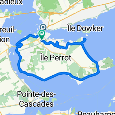
 From L'Île-Perrot to Pincourt
- Dystans
- 26,9 km
- Przewyższenia
- 62 m
- Spadek
- 61 m
- Lokalizacja
- Sainte-Anne-de-Bellevue, Québec, Kanada
 Trip c. 2000, Part 1: Sainte-Anne to Aylmer in a day
- Dystans
- 188,2 km
- Przewyższenia
- 215 m
- Spadek
- 150 m
- Lokalizacja
- Sainte-Anne-de-Bellevue, Québec, Kanada
 Ste. Anne de Bellevue-Les Cedres
- Dystans
- 45,3 km
- Przewyższenia
- 38 m
- Spadek
- 40 m
- Lokalizacja
- Sainte-Anne-de-Bellevue, Québec, Kanada
 23 Rue Maple, Ste-Anne-de-Bellevue to 26 Rue Maple, Ste-Anne-de-Bellevue
- Dystans
- 26,4 km
- Przewyższenia
- 35 m
- Spadek
- 38 m
- Lokalizacja
- Sainte-Anne-de-Bellevue, Québec, Kanada
 167 Rue Sainte-Anne, Sainte-Anne-de-Bellevue to 167 Rue Sainte-Anne, Sainte-Anne-de-Bellevue
- Dystans
- 24 km
- Przewyższenia
- 58 m
- Spadek
- 59 m
- Lokalizacja
- Sainte-Anne-de-Bellevue, Québec, Kanada
 08.11 Parc Cap-Saint-Jacques
- Dystans
- 56,3 km
- Przewyższenia
- 91 m
- Spadek
- 87 m
- Lokalizacja
- Sainte-Anne-de-Bellevue, Québec, Kanada
 Grand Blvd, L'Île-Perrot to Grand Blvd, L'Île-Perrot
- Dystans
- 32 km
- Przewyższenia
- 69 m
- Spadek
- 67 m
- Lokalizacja
- Sainte-Anne-de-Bellevue, Québec, Kanada
Otwórz ją w aplikacji