

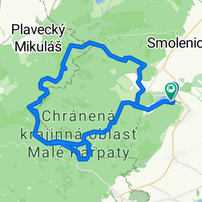
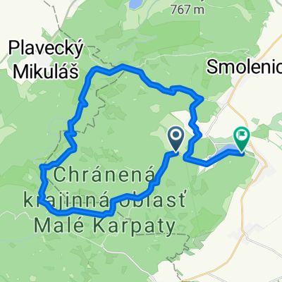
Katarinka okruh z Parkoviska
Trasa rowerowa rozpoczynająca się w Smolenice, Kraj trnawski, Słowacja.
Przegląd
O tej trasie
Discover the thrill of cycling along this scenic 31.2 km route, perfect for adventure seekers. The journey begins at a manageable 394 meters, gradually ascending to a peak elevation of 394 meters, offering breathtaking views along the way. Prepare for a mix of terrains—paved paths and sections with a touch of gravel—that will keep your ride dynamic and engaging. With an ascent of 651 meters and a descent of 649 meters, this route promises a well-rounded challenge. Whether you're a seasoned cyclist or just looking for a new adventure, this route is sure to provide an exhilarating experience. Enjoy the ride!
Wygenerowane przez AI
- 3 h 25 min
- Czas
- 31,2 km
- Dystans
- 651 m
- Przewyższenia
- 650 m
- Spadek
- 9,1 km/h
- Śr. Prędkość
- 395 m
- Maks. wysokość

Jakość trasy
Typy dróg i nawierzchnie na trasie
Typy dróg
Droga leśna
25,9 km
(83 %)
Droga dojazdowa
4,1 km
(13 %)
Powierzchnie
Utwardzona
8,4 km
(27 %)
Nieutwardzona
21,2 km
(68 %)
Żwir
12,5 km
(40 %)
Asfalt
8,1 km
(26 %)
Kontynuuj z Bikemap
Użyj, edytuj lub pobierz tę trasę rowerową
Chcesz przejechać trasę Katarinka okruh z Parkoviska lub dostosować ją do swojej wycieczki? Oto, co możesz zrobić z tą trasą na Bikemap:
Darmowe funkcje
- Zapisz tę trasę jako ulubioną lub w kolekcji
- Skopiuj i zaplanuj swoją wersję tej trasy
- Synchronizuj swoją trasę z Garminem lub Wahoo
Funkcje Premium
3 dni bezpłatnej wersji próbnej lub jednorazowa opłata. Dowiedz się więcej o Bikemap Premium.
- Nawiguj po tej trasie na iOS i Androidzie
- Eksportuj plik GPX / KML tej trasy
- Stwórz swój własny wydruk (wypróbuj za darmo)
- Pobierz tę trasę do nawigacji offline
Odkryj więcej funkcji Premium.
Uzyskaj Bikemap PremiumOd naszej społeczności
Smolenice: Inne popularne trasy rozpoczynające się tutaj
 malé karpaty
- Dystans
- 48,7 km
- Przewyższenia
- 1502 m
- Spadek
- 1493 m
- Lokalizacja
- Smolenice, Kraj trnawski, Słowacja
 Malé Karpaty - Vápenná, Klokoč, Báborská,
- Dystans
- 13,8 km
- Przewyższenia
- 609 m
- Spadek
- 609 m
- Lokalizacja
- Smolenice, Kraj trnawski, Słowacja
 Katarinka okruh z Parkoviska
- Dystans
- 31,2 km
- Przewyższenia
- 651 m
- Spadek
- 650 m
- Lokalizacja
- Smolenice, Kraj trnawski, Słowacja
 48.505, 17.318 až 48.506, 17.316
- Dystans
- 14,3 km
- Przewyższenia
- 369 m
- Spadek
- 377 m
- Lokalizacja
- Smolenice, Kraj trnawski, Słowacja
 Boleraz Bohdanovce(Dolna Krupa)
- Dystans
- 29,2 km
- Przewyższenia
- 181 m
- Spadek
- 184 m
- Lokalizacja
- Smolenice, Kraj trnawski, Słowacja
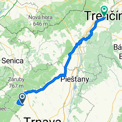 Horné Orešany, Horné Orešany až Štúrovo nám, Trenčín
- Dystans
- 92,3 km
- Przewyższenia
- 902 m
- Spadek
- 889 m
- Lokalizacja
- Smolenice, Kraj trnawski, Słowacja
 mon repos
- Dystans
- 39,5 km
- Przewyższenia
- 1159 m
- Spadek
- 1159 m
- Lokalizacja
- Smolenice, Kraj trnawski, Słowacja
 Lošonec do Nivy
- Dystans
- 29,5 km
- Przewyższenia
- 820 m
- Spadek
- 851 m
- Lokalizacja
- Smolenice, Kraj trnawski, Słowacja
Otwórz ją w aplikacji