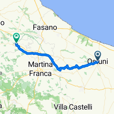
Piazza della Libertà, Ostuni to Largo Matellotta, Alberobello
- 40,7 km
- 587 m
- 386 m
- Ostuni, Puglia, Włochy
Trasa rowerowa rozpoczynająca się w Ostuni, Puglia, Włochy.
Przegląd
utworzono 7 dni temu temu
Jakość trasy
Spokojna droga
23,1 km
30 %
Droga
14,6 km
19 %
Utwardzona
21,6 km
(28 %)
Asfalt
21,6 km
28 %
Niezdefiniowany
55,5 km
72 %
Najważniejsze punkty trasy
Porta Santo Stefano
Palazzo Ducale 10:30 am–12:30 pm 4–6 pm You can walk through 5 rooms in the palace to see beautiful Frescoes on the walls. Entrance cost via a donation
Piazza Plebiscito
Piazza Maria Immacolata
Basilica di San Martino
Castello di Francavilla Fontana Castello Imperiali
Basilica of Oria: The Cathedral of Oria, also known as the Basilica of Santa Maria Assunta, is a magnificent example of Baroque architecture. Built in the 18th century, the basilica is famous for its richly decorated façade and sumptuous interior, featuring frescoes, stuccoes, and sacred artwork. The basilica's dome is visible from various points in the city, making it an important landmark for residents and visitors alike. Also Crypt of the Mummies.
Castle of Oria Situated in a dominant position on a hill, Oria Castle is one of the city's most iconic symbols. It was built by Emperor Frederick II of Swabia in the 13th century. The imposing structure is composed of towers and defensive walls, and offers breathtaking panoramic views of the city and surrounding countryside. Inside the castle, you can visit historic rooms, courtyards, and underground passages that reveal the area's medieval history.
Santuario San Cosimo alla Macchia
Kontynuuj z Bikemap
Chcesz przejechać trasę 12. Ostuni to Manduria lub dostosować ją do swojej wycieczki? Oto, co możesz zrobić z tą trasą na Bikemap:
3 dni bezpłatnej wersji próbnej lub jednorazowa opłata. Dowiedz się więcej o Bikemap Premium.
Odkryj więcej funkcji Premium.
Uzyskaj Bikemap PremiumOd naszej społeczności
Otwórz ją w aplikacji