

Recreational Trails Map - Gateway Country - Route 5
Trasa rowerowa rozpoczynająca się w Prince Edward, Ontario, Kanada.
Przegląd
O tej trasie
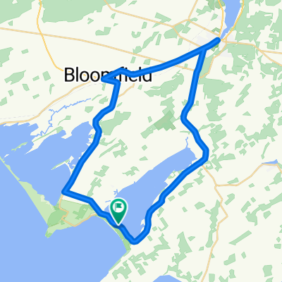
I just traced the route as outlined to get a reading on the distance because it was not included on the Recreational Trails Map (a large oversite in my opinion). The description given:<br />Picton - Sand Banks Loop - This is the beach tour, so be prpared for traffic on the weekends. Head west out of Picton on Hwy 33 to CR10 and follow south to Cherry Valley. Hug the shore of East Lake. At Salmon Point, turn right and pass through The Outlet and over to Sandbanks PP, or West Lake, as you chosse. Head back up West Lake Rd to the pretty village of Bloomfield, featuring a vibrant main street. Return to Picton along Hwy33. Generally flat, a few rolling hills on the last stretch.<br /><br /><br />If we bike it, I will add details.
- -:--
- Czas
- 40,4 km
- Dystans
- 107 m
- Przewyższenia
- 109 m
- Spadek
- ---
- Śr. Prędkość
- ---
- Maks. wysokość
Kontynuuj z Bikemap
Użyj, edytuj lub pobierz tę trasę rowerową
Chcesz przejechać trasę Recreational Trails Map - Gateway Country - Route 5 lub dostosować ją do swojej wycieczki? Oto, co możesz zrobić z tą trasą na Bikemap:
Darmowe funkcje
- Zapisz tę trasę jako ulubioną lub w kolekcji
- Skopiuj i zaplanuj swoją wersję tej trasy
- Synchronizuj swoją trasę z Garminem lub Wahoo
Funkcje Premium
3 dni bezpłatnej wersji próbnej lub jednorazowa opłata. Dowiedz się więcej o Bikemap Premium.
- Nawiguj po tej trasie na iOS i Androidzie
- Eksportuj plik GPX / KML tej trasy
- Stwórz swój własny wydruk (wypróbuj za darmo)
- Pobierz tę trasę do nawigacji offline
Odkryj więcej funkcji Premium.
Uzyskaj Bikemap PremiumOd naszej społeczności
Prince Edward: Inne popularne trasy rozpoczynające się tutaj
 randonnée de vacance
- Dystans
- 60,7 km
- Przewyższenia
- 241 m
- Spadek
- 238 m
- Lokalizacja
- Prince Edward, Ontario, Kanada
 BloomfieldSandbanksloop
- Dystans
- 51,9 km
- Przewyższenia
- 127 m
- Spadek
- 134 m
- Lokalizacja
- Prince Edward, Ontario, Kanada
 Recreational Trails Map - Gateway Country - Route 5
- Dystans
- 40,4 km
- Przewyższenia
- 107 m
- Spadek
- 109 m
- Lokalizacja
- Prince Edward, Ontario, Kanada
 Bloomfield to County Cider Factory and back
- Dystans
- 66,5 km
- Przewyższenia
- 248 m
- Spadek
- 245 m
- Lokalizacja
- Prince Edward, Ontario, Kanada
 May 17, 2015, 3:28 PM
- Dystans
- 38,3 km
- Przewyższenia
- 110 m
- Spadek
- 109 m
- Lokalizacja
- Prince Edward, Ontario, Kanada
 swamp college to church camp
- Dystans
- 33,4 km
- Przewyższenia
- 62 m
- Spadek
- 60 m
- Lokalizacja
- Prince Edward, Ontario, Kanada
 classic western wine route
- Dystans
- 59,9 km
- Przewyższenia
- 76 m
- Spadek
- 76 m
- Lokalizacja
- Prince Edward, Ontario, Kanada
 canada day 100k
- Dystans
- 104,5 km
- Przewyższenia
- 126 m
- Spadek
- 126 m
- Lokalizacja
- Prince Edward, Ontario, Kanada
Otwórz ją w aplikacji