

MTB Tour zum großen Arber
Trasa rowerowa rozpoczynająca się w Bayerisch Eisenstein, Bawaria, Niemcy.
Przegląd
O tej trasie
0
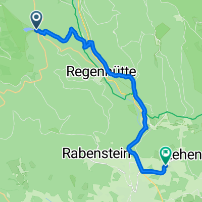
You'll begin your ride on a well-maintained gravel path, mostly paved, for the first half of the journey, enjoying a smooth and consistent surface. The trail transitions into a forested road, offering a more natural and scenic experience. Around ten kilometres into the ride, you'll encounter a mix of paved and unpaved sections, providing a varied terrain to keep things interesting. The ascent begins with a moderate incline, gradually gaining elevation as you ride. After a short while, the path becomes steeper, with some loose gravel, but it's manageable and offers a rewarding challenge. As you continue, you'll enjoy a more gentle descent, followed by another moderate climb. The trail ends with a slight incline, leading to a final descent. Overall, this route offers a pleasant combination of paved and unpaved sections, with a mix of forested and open areas. It's a great choice for those looking for a scenic and enjoyable ride.
Wygenerowane przez AI
- 1:01 h
- Czas
- 8 km
- Dystans
- 618 m
- Przewyższenia
- 276 m
- Spadek
- 8 km/h
- Śr. Prędkość
- 1421 m
- Maks. wysokość
Rennsemme Rudi
utworzono 2 miesiące temu temu
Jakość trasy
Typy dróg i nawierzchnie na trasie
Typy dróg
Droga leśna
4,7 km
58 %
Droga dojazdowa
3,4 km
42 %
Powierzchnie
Nieutwardzona
8 km
(100 %)
Żwir
7,5 km
93 %
Otoczaki
0,3 km
4 %
Luźny żwir
0,2 km
3 %
Kontynuuj z Bikemap
Użyj, edytuj lub pobierz tę trasę rowerową
Chcesz przejechać trasę MTB Tour zum großen Arber lub dostosować ją do swojej wycieczki? Oto, co możesz zrobić z tą trasą na Bikemap:
Darmowe funkcje
- Zapisz tę trasę jako ulubioną lub w kolekcji
- Skopiuj i zaplanuj swoją wersję tej trasy
- Synchronizuj swoją trasę z Garminem lub Wahoo
Funkcje Premium
3 dni bezpłatnej wersji próbnej lub jednorazowa opłata. Dowiedz się więcej o Bikemap Premium.
- Nawiguj po tej trasie na iOS i Androidzie
- Eksportuj plik GPX / KML tej trasy
- Stwórz swój własny wydruk (wypróbuj za darmo)
- Pobierz tę trasę do nawigacji offline
Odkryj więcej funkcji Premium.
Uzyskaj Bikemap PremiumOd naszej społeczności
Bayerisch Eisenstein: Inne popularne trasy rozpoczynające się tutaj
- Graf Arbersee, Bayerisch Eisenstein nach Lehener Straße, Lindberg0
- 15,3 km
- 198 m
- 505 m
- Bayerisch Eisenstein, Bawaria, Niemcy


Otwórz ją w aplikacji