

6. Etappe: Les Gets - Col des Aravis
Trasa rowerowa rozpoczynająca się w Gets, Owernia-Rodan-Alpy, Francja.
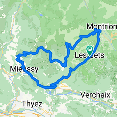
Przegląd
O tej trasie
Col de la Colombière, huhu
- -:--
- Czas
- 65,8 km
- Dystans
- 1668 m
- Przewyższenia
- 1605 m
- Spadek
- ---
- Śr. Prędkość
- ---
- Maks. wysokość

Jakość trasy
Typy dróg i nawierzchnie na trasie
Typy dróg
Spokojna droga
3,9 km
(6 %)
Droga dojazdowa
1,3 km
(2 %)
Powierzchnie
Utwardzona
59,9 km
(91 %)
Asfalt
59,9 km
(91 %)
Niezdefiniowany
5,9 km
(9 %)
Najważniejsze punkty trasy
Punkty zainteresowania na trasie
Interesujące miejsce po 13,3 km
Auf der Suche nach nem ordentlichen Frühstück. Wie, nichts außer Kaffee und ein Croissant? Dann weiter nach Châtillion. Sonst ist Taninges super nett, kein Touriort, netter Markt.
Interesujące miejsce po 17 km
Super Bäckerei direkt an der Straße. Hab da 12€ gelassen. Echtes dunkles Körnerbrot!! Super!
Interesujące miejsce po 35,5 km
Ab hier wirds hart.
Interesujące miejsce po 42,9 km
Kaputt. Fertig. Ca. 2:10 h, am Ende 12% und das Ziel schon so lange vor Augen. Das tut weh. Egal, geschafft ist geschafft. Ohne Absteigen.
Interesujące miejsce po 60,4 km
Oh, meidet diesen Ort. Auf jeden Fall im Sommer.
Interesujące miejsce po 65,8 km
Einer der spannendsten Schlafplätze. Später mehr.
Kontynuuj z Bikemap
Użyj, edytuj lub pobierz tę trasę rowerową
Chcesz przejechać trasę 6. Etappe: Les Gets - Col des Aravis lub dostosować ją do swojej wycieczki? Oto, co możesz zrobić z tą trasą na Bikemap:
Darmowe funkcje
- Zapisz tę trasę jako ulubioną lub w kolekcji
- Skopiuj i zaplanuj swoją wersję tej trasy
- Synchronizuj swoją trasę z Garminem lub Wahoo
Funkcje Premium
3 dni bezpłatnej wersji próbnej lub jednorazowa opłata. Dowiedz się więcej o Bikemap Premium.
- Nawiguj po tej trasie na iOS i Androidzie
- Eksportuj plik GPX / KML tej trasy
- Stwórz swój własny wydruk (wypróbuj za darmo)
- Pobierz tę trasę do nawigacji offline
Odkryj więcej funkcji Premium.
Uzyskaj Bikemap PremiumOd naszej społeczności
Gets: Inne popularne trasy rozpoczynające się tutaj
 Day 2
Day 2- Dystans
- 158,9 km
- Przewyższenia
- 3540 m
- Spadek
- 3279 m
- Lokalizacja
- Gets, Owernia-Rodan-Alpy, Francja
 1.Route des Grandes Alpes - Day One
- Dystans
- 74 km
- Przewyższenia
- 2063 m
- Spadek
- 2090 m
- Lokalizacja
- Gets, Owernia-Rodan-Alpy, Francja
 Tour du Mont-Chéry
- Dystans
- 39,3 km
- Przewyższenia
- 902 m
- Spadek
- 900 m
- Lokalizacja
- Gets, Owernia-Rodan-Alpy, Francja
 2017 Alps 1
- Dystans
- 112,9 km
- Przewyższenia
- 2874 m
- Spadek
- 2864 m
- Lokalizacja
- Gets, Owernia-Rodan-Alpy, Francja
 6. Etappe: Les Gets - Col des Aravis
- Dystans
- 65,8 km
- Przewyższenia
- 1668 m
- Spadek
- 1605 m
- Lokalizacja
- Gets, Owernia-Rodan-Alpy, Francja
 Les Gets-Col La Joux Verte Montriond -Les Gets
- Dystans
- 41,3 km
- Przewyższenia
- 1057 m
- Spadek
- 1062 m
- Lokalizacja
- Gets, Owernia-Rodan-Alpy, Francja
 Les Gets - Ramaz - Encrenaz
- Dystans
- 56,3 km
- Przewyższenia
- 1437 m
- Spadek
- 1434 m
- Lokalizacja
- Gets, Owernia-Rodan-Alpy, Francja
 joux plane - joux verte - col de l'encrenaz
- Dystans
- 86,7 km
- Przewyższenia
- 2857 m
- Spadek
- 2858 m
- Lokalizacja
- Gets, Owernia-Rodan-Alpy, Francja
Otwórz ją w aplikacji