

Radtour Korea Oktober 2012
Trasa rowerowa rozpoczynająca się w Seul, Seoul, Korea Południowa.
Przegląd
O tej trasie
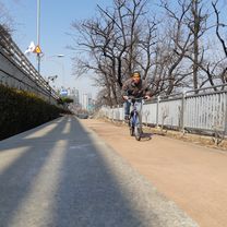
W Korei, jak w niewielu innych krajach, tradycja łączy się z nowoczesnością: podczas gdy codzienne życie w Korei jest naznaczone wysoką technologią, wiele kulturowych skarbów z przeszłości jest zachowanych. Nie tylko królewskie pałace w Seulu i liczne historyczne miejsca w Gyeongju, które ma ponad 1000-letnią historię jako stolica upadłego królestwa Silla, ukazują bogactwo koreańskiej kultury. Korea przyciąga również fascynującymi krajobrazami, ponad 70% kraju pokryte jest górami. Ta wyjątkowa kombinacja kultury i natury sprawia, że Korea jest idealnym krajem do jazdy na rowerze, który będziemy poznawać podczas tej podróży. Razem z Holendrem Janem Boosterą, który od wielu lat mieszka w Korei i praktycznie przejechał rowerem każdą drogę w kraju, opracowaliśmy bardzo ładną trasę z dala od uczęszczanych dróg. Pierwszy tydzień jedziemy z Seulu wzdłuż granicy z Koreą Północną na wschód, a następnie skręcamy na południe. Stara stolica Gyeongju to punkt końcowy wycieczki rowerowej po kontynencie.
- -:--
- Czas
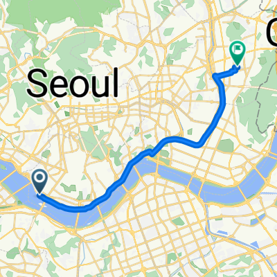
- 801,5 km
- Dystans
- 3285 m
- Przewyższenia
- 3252 m
- Spadek
- ---
- Śr. Prędkość
- ---
- Maks. wysokość

Kontynuuj z Bikemap
Użyj, edytuj lub pobierz tę trasę rowerową
Chcesz przejechać trasę Radtour Korea Oktober 2012 lub dostosować ją do swojej wycieczki? Oto, co możesz zrobić z tą trasą na Bikemap:
Darmowe funkcje
- Zapisz tę trasę jako ulubioną lub w kolekcji
- Skopiuj i zaplanuj swoją wersję tej trasy
- Podziel trasę na etapy, aby utworzyć kilkudniową wycieczkę
- Synchronizuj swoją trasę z Garminem lub Wahoo
Funkcje Premium
3 dni bezpłatnej wersji próbnej lub jednorazowa opłata. Dowiedz się więcej o Bikemap Premium.
- Nawiguj po tej trasie na iOS i Androidzie
- Eksportuj plik GPX / KML tej trasy
- Stwórz swój własny wydruk (wypróbuj za darmo)
- Pobierz tę trasę do nawigacji offline
Odkryj więcej funkcji Premium.
Uzyskaj Bikemap PremiumOd naszej społeczności
Seul: Inne popularne trasy rozpoczynające się tutaj
 test
test- Dystans
- 39,4 km
- Przewyższenia
- 439 m
- Spadek
- 439 m
- Lokalizacja
- Seul, Seoul, Korea Południowa
 보통 경로
보통 경로- Dystans
- 19,6 km
- Przewyższenia
- 94 m
- Spadek
- 97 m
- Lokalizacja
- Seul, Seoul, Korea Południowa
 zeppelin_viaggiamondo_corea_2013
- Dystans
- 835,5 km
- Przewyższenia
- 5814 m
- Spadek
- 5824 m
- Lokalizacja
- Seul, Seoul, Korea Południowa
 Seoul to Guri City
- Dystans
- 30,7 km
- Przewyższenia
- 251 m
- Spadek
- 244 m
- Lokalizacja
- Seul, Seoul, Korea Południowa
 HRR 2016 Season opner + climb
- Dystans
- 79 km
- Przewyższenia
- 329 m
- Spadek
- 327 m
- Lokalizacja
- Seul, Seoul, Korea Południowa
 여의도-반포-잠실 한강 라이딩 코스
- Dystans
- 16,7 km
- Przewyższenia
- 223 m
- Spadek
- 224 m
- Lokalizacja
- Seul, Seoul, Korea Południowa
 홍은동 22 to 경서동 526−2
- Dystans
- 47,2 km
- Przewyższenia
- 338 m
- Spadek
- 419 m
- Lokalizacja
- Seul, Seoul, Korea Południowa
 ride from Yongsan-gu to Seongnamsi
- Dystans
- 27,7 km
- Przewyższenia
- 87 m
- Spadek
- 87 m
- Lokalizacja
- Seul, Seoul, Korea Południowa
Otwórz ją w aplikacji