

To via verde from Zahara
Trasa rowerowa rozpoczynająca się w Zahara, Andaluzja, Hiszpania.
Przegląd
O tej trasie
Urocze powitanie i jedzenie przy wejściu na stację do Via Verde w Coripe. Droga do Coripe i Via Verde była piękna.
Miła, cicha przejażdżka aż do powrotu trasą A384 (którą wybraliśmy, aby zaoszczędzić czas, bo robiło się późno) bardzo ruchliwa, dużo ciężarówek i okropny tunel. Unikaj tego, wybierając ścieżkę do Algodonales w Campo Huerta.
- -:--
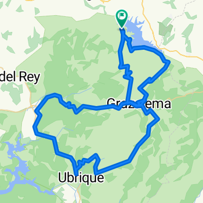
- Czas
- 67,1 km
- Dystans
- 834 m
- Przewyższenia
- 834 m
- Spadek
- ---
- Śr. Prędkość
- ---
- Maks. wysokość
Jakość trasy
Typy dróg i nawierzchnie na trasie
Typy dróg
Droga
38,3 km
(57 %)
Ścieżka
9,4 km
(14 %)
Powierzchnie
Utwardzona
26,2 km
(39 %)
Nieutwardzona
4,7 km
(7 %)
Asfalt
26,2 km
(39 %)
Żwir
4,7 km
(7 %)
Niezdefiniowany
36,3 km
(54 %)
Najważniejsze punkty trasy
Punkty zainteresowania na trasie
Interesujące miejsce po 44,2 km
SO close to the main Jerez – Antequera road, it is surprising that Venta El Castillejo turns out to be one of the most peaceful, rural dining secrets in Andalucia. But sitting on the south-facing terrace of this sensitively converted old farmhouse, you feel completely cut off from the modern age. Looking out into the Serrania de Ronda, the only sign of human life is the pretty white-washed village of El Gastor far in the distance. Otherwise it is just distant shimmering mountains and oak-scattered hills with the occasional Iberian pig, goat herd or the celebrated brown Retinto cows of Cadiz province. Some of the last completely unspoilt countryside in the vicinity of Ronda, the real beauty is the handsome town of Olvera, sitting high on a hill some ten minutes East.
Kontynuuj z Bikemap
Użyj, edytuj lub pobierz tę trasę rowerową
Chcesz przejechać trasę To via verde from Zahara lub dostosować ją do swojej wycieczki? Oto, co możesz zrobić z tą trasą na Bikemap:
Darmowe funkcje
- Zapisz tę trasę jako ulubioną lub w kolekcji
- Skopiuj i zaplanuj swoją wersję tej trasy
- Synchronizuj swoją trasę z Garminem lub Wahoo
Funkcje Premium
3 dni bezpłatnej wersji próbnej lub jednorazowa opłata. Dowiedz się więcej o Bikemap Premium.
- Nawiguj po tej trasie na iOS i Androidzie
- Eksportuj plik GPX / KML tej trasy
- Stwórz swój własny wydruk (wypróbuj za darmo)
- Pobierz tę trasę do nawigacji offline
Odkryj więcej funkcji Premium.
Uzyskaj Bikemap PremiumOd naszej społeczności
Zahara: Inne popularne trasy rozpoczynające się tutaj
 To via verde from Zahara
- Dystans
- 67,1 km
- Przewyższenia
- 834 m
- Spadek
- 834 m
- Lokalizacja
- Zahara, Andaluzja, Hiszpania
 Pto Las Palomas Junio 2018
- Dystans
- 39,3 km
- Przewyższenia
- 1060 m
- Spadek
- 1063 m
- Lokalizacja
- Zahara, Andaluzja, Hiszpania
 Las Palomas - El Boyar - variante II - www.zonaciclista.com
- Dystans
- 89,6 km
- Przewyższenia
- 1764 m
- Spadek
- 1788 m
- Lokalizacja
- Zahara, Andaluzja, Hiszpania
 Zahara-Las Palomas-Grazalema-Arroyomolinos-Zahara
- Dystans
- 35,6 km
- Przewyższenia
- 1487 m
- Spadek
- 1594 m
- Lokalizacja
- Zahara, Andaluzja, Hiszpania
 Cicloturista Los Pueblos Blancos 3
- Dystans
- 52,9 km
- Przewyższenia
- 1154 m
- Spadek
- 936 m
- Lokalizacja
- Zahara, Andaluzja, Hiszpania
 Some of the way up to Grazalema
- Dystans
- 9,6 km
- Przewyższenia
- 819 m
- Spadek
- 174 m
- Lokalizacja
- Zahara, Andaluzja, Hiszpania
 GRAZALEMA 2017 UNICA
- Dystans
- 89,2 km
- Przewyższenia
- 2074 m
- Spadek
- 2058 m
- Lokalizacja
- Zahara, Andaluzja, Hiszpania
 Grazalema 2018
- Dystans
- 85,4 km
- Przewyższenia
- 2106 m
- Spadek
- 2009 m
- Lokalizacja
- Zahara, Andaluzja, Hiszpania
Otwórz ją w aplikacji