
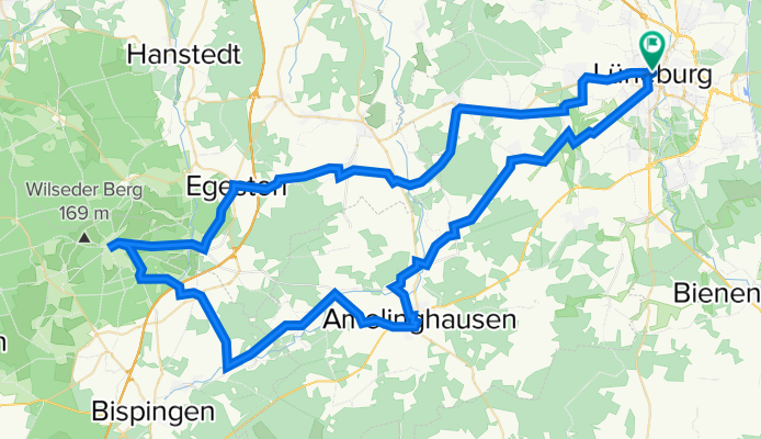
Lüneburger Heidetour
Trasa rowerowa rozpoczynająca się w Lüneburg, Lower Saxony, Germany.
Przegląd
O tej trasie
<span style="font-size: small;"><font color="#000000"><font face="Calibri">Höhepunkte der Heide Tour:</font></font></span>
<span style="font-size: small;"><font color="#000000"><font face="Calibri">Startpunkt: Tourist-Information Lüneburg</font></font></span>
<span style="font-size: small;"><font color="#000000"><font face="Calibri">Das Naturschutzgebiet Lüneburger Heide ist das älteste<font size="3"> </font>und eines der größten Deutschlands. Auf dieser</font></font></span>
<span style="font-size: small;"><font color="#000000"><font face="Calibri">Tour können Sie die für die<font size="3"> </font>Lüne- burger Heide typische<font size="3"> </font>Landschaft mit all ihren Facetten entdecken: weite<font size="3"> </font>Heideflächen umgeben von Wäldern und Mooren, ein nur leicht</font></font></span>
<span style="font-size: small;"><font color="#000000"><font face="Calibri">hügeliges Gelände, ideal zum Rad- fahren. Viele Flüsse und Seen<font size="3"> </font>bieten eine Abwechslung zu den blühenden Heideflächen und<font size="3"> </font>satt- grünen Wäldern, die Sandböden sind gut befahrbar.<font size="3"> </font></font></font></span>
<span style="font-size: small;"><font color="#000000"><font face="Calibri">Amelinghausen: In dem 700 Jahre alten Heideort findet jedes<font size="3"> </font>Jahr im August eines der größten Heideblütenfeste der Region<font size="3"> </font>statt. Sehenswert is<font size="3">t </font>außerdem die Oldendorfer Totenstatt, eines<font size="3"> </font>der inte- ressantesten Steingräber im<font size="3"> </font>Land- kreis Lüneburg.<font size="3"> </font>Weitere Infos unter: www.amelinghausen.de</font></font></span>
<span style="font-size: small;"><font color="#000000"><font face="Calibri">Egestorf: Den Ortsmittelpunkt bildet die St.-Stephanus-Kirche</font></font></span>
<span style="font-size: small;"><font color="#000000"><font face="Calibri">aus dem Jahre 1645 mit einer schöner Gartenanlage, eine<font size="3"> </font>Fach- werk-</font></font></span><span style="font-size: small;"><font color="#000000"><font face="Calibri">Kirche mit abseits stehendem hölzernen Glockenturm, die </font></font></span><span style="font-size: small;"><font color="#000000"><font face="Calibri">an die nordischen Stabkirchen erinnert. Im Inneren ist ein reich<font size="3"> </font>mit Statuetten und Bildern geschmückte<font size="3">n </font>Altar- aufsatz zu besichtigen.<font size="3"> </font>Auf dem Dorfplatz vor der Kirche finden Sie eine Büste de<font size="3">s </font>Heidepastors Wilhelm Bode. Der Begründer des Naturschutzgebiets<font size="3"> </font>Lüneburger Heide lebte und wirkte hier von 1886 bis<font size="3"> </font>1923. Ihm ist es zu verdanken, dass ein Teil der Heidelandschaft<font size="3"> </font>für die Nachwelt erhalten blieb.</font></font></span>
<span style="font-size: small;"><font color="#000000"><font face="Calibri">Wilseder Berg: Entstanden ist die Erhebung während der vorletzten</font></font></span>
<span style="font-size: small;"><font color="#000000"><font face="Calibri">Eiszeit, der Saaleeiszeit; es handelt sich dabei um einen Teil<font size="3"> </font>einer Endmoräne. Der Wilseder Berg bildet die höchste Erhebung<font size="3"> </font>Nord- deutschlands mit 169,2 m und das Zentrum der größten<font size="3"> </font>Heideflächen</font></font></span>
<span style="font-size: small;"><font color="#000000"><font face="Calibri">Europas. Einmalig ist der Blick über die blühende<font size="3"> </font>Landschaft mit ihren charakteristische<font size="3">n </font>Wacholder- büschen.</font></font></span>
- -:--
- Czas
- 86,9 km
- Dystans
- 340 m
- Przewyższenia
- 338 m
- Spadek
- ---
- Śr. Prędkość
- ---
- Maks. wysokość

Jakość trasy
Typy dróg i nawierzchnie na trasie
Typy dróg
Spokojna droga
33,6 km
(39 %)
Droga
23,3 km
(27 %)
Powierzchnie
Utwardzona
70 km
(81 %)
Nieutwardzona
9,4 km
(11 %)
Asfalt
60,6 km
(70 %)
Kostka brukowa
5,1 km
(6 %)
Najważniejsze punkty trasy
Punkty zainteresowania na trasie
Interesujące miejsce po 0,4 km
Parkhaus am Graalwall
Interesujące miejsce po 0,8 km
Bus und PKW Parkplatz An den Sülwiesen Anfahrt Sülzwiesen Stellplätze 450 Lage City-Nähe: 7 Min Öffnungszeiten: 24 Stunden durchgehend geöffnet Höchstparkdauer unbegrenzt Kosten keine
Interesujące miejsce po 6,6 km
Waldhof Böhmsholz Biergarten / Spielplatz
Interesujące miejsce po 39,5 km
Interesujące miejsce po 42,8 km
Holzschild nach Hörpel folgen
Interesujące miejsce po 63,7 km
Parkplatz
Interesujące miejsce po 63,8 km
Parkplatz auch Für Wohnwagen und Wohnmobile
Interesujące miejsce po 86,6 km
Parkhaus Neue Sülze
Kontynuuj z Bikemap
Użyj, edytuj lub pobierz tę trasę rowerową
Chcesz przejechać trasę Lüneburger Heidetour lub dostosować ją do swojej wycieczki? Oto, co możesz zrobić z tą trasą na Bikemap:
Darmowe funkcje
- Zapisz tę trasę jako ulubioną lub w kolekcji
- Skopiuj i zaplanuj swoją wersję tej trasy
- Podziel trasę na etapy, aby utworzyć kilkudniową wycieczkę
- Synchronizuj swoją trasę z Garminem lub Wahoo
Funkcje Premium
3 dni bezpłatnej wersji próbnej lub jednorazowa opłata. Dowiedz się więcej o Bikemap Premium.
- Nawiguj po tej trasie na iOS i Androidzie
- Eksportuj plik GPX / KML tej trasy
- Stwórz swój własny wydruk (wypróbuj za darmo)
- Pobierz tę trasę do nawigacji offline
Odkryj więcej funkcji Premium.
Uzyskaj Bikemap PremiumOd naszej społeczności
Lüneburg: Inne popularne trasy rozpoczynające się tutaj
 Lüneburg (Tour II)
- Dystans
- 30,7 km
- Przewyższenia
- 88 m
- Spadek
- 88 m
- Lokalizacja
- Lüneburg, Lower Saxony, Germany
 fur Diana und Julia
- Dystans
- 56,2 km
- Przewyższenia
- 184 m
- Spadek
- 182 m
- Lokalizacja
- Lüneburg, Lower Saxony, Germany
 Lüneburg (21,1 km)
- Dystans
- 21,6 km
- Przewyższenia
- 98 m
- Spadek
- 99 m
- Lokalizacja
- Lüneburg, Lower Saxony, Germany
 Alte Salzstraße
- Dystans
- 92,1 km
- Przewyższenia
- 100 m
- Spadek
- 106 m
- Lokalizacja
- Lüneburg, Lower Saxony, Germany
 Lüneburg: Lüneburger Backsteintour (Tagestour 20 km)
- Dystans
- 19,7 km
- Przewyższenia
- 0 m
- Spadek
- 0 m
- Lokalizacja
- Lüneburg, Lower Saxony, Germany
 Die Hitzacker Runde
- Dystans
- 138,7 km
- Przewyższenia
- 364 m
- Spadek
- 365 m
- Lokalizacja
- Lüneburg, Lower Saxony, Germany
 immer geradeaus
- Dystans
- 40,6 km
- Przewyższenia
- 186 m
- Spadek
- 165 m
- Lokalizacja
- Lüneburg, Lower Saxony, Germany
 2018 Printentour 3/3 Lüneburg Bramfeld
- Dystans
- 67,7 km
- Przewyższenia
- 71 m
- Spadek
- 75 m
- Lokalizacja
- Lüneburg, Lower Saxony, Germany
Otwórz ją w aplikacji