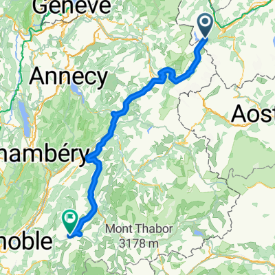
- 35,6 km
- 658 m
- 964 m
- Martigny-Combe, Valais, Szwajcaria
VTT MONT BLANC Vllorcine Albertville
Trasa rowerowa rozpoczynająca się w Martigny-Combe, Valais, Szwajcaria.
Przegląd
O tej trasie
MTB MONT BLANC
- -:--
- Czas
- 432,8 km
- Dystans
- 8172 m
- Przewyższenia
- 8462 m
- Spadek
- ---
- Śr. Prędkość
- ---
- Maks. wysokość
utworzono 12 lat temu temu
Najważniejsze punkty trasy
Punkty zainteresowania na trasie
Interesujące miejsce po 0,6 km
le chatelard frontière
Interesujące miejsce po 11,9 km
chemin balcon de Argentières à CHAMONIX.
Interesujące miejsce po 84,6 km
le col des saisies raide
Nocleg po 85,4 km
les saisies
Interesujące miejsce po 101,8 km
dernier pt d'eau pour Bisanne ATTENTION..!!!
Woda pitna po 108 km
10%!!!
Interesujące miejsce po 111,3 km
Interesujące miejsce po 117,2 km
Le signal de Bisanne très difficile de villard sur doron 10%--- pas d'eau..
Interesujące miejsce po 268,6 km
Nocleg po 280,6 km
hauteluce
Nocleg po 286,6 km
beaufort sur doron
Nocleg po 293,2 km
areches -beaufort
Interesujące miejsce po 294,9 km
lac de st guérin
Interesujące miejsce po 299,3 km
le col du pré
Interesujące miejsce po 299,3 km
Interesujące miejsce po 304,5 km
le col du méraillet
Interesujące miejsce po 304,6 km
le barrage de Roselend
Interesujące miejsce po 412,5 km
le col du cormet de roselend
Kontynuuj z Bikemap
Użyj, edytuj lub pobierz tę trasę rowerową
Chcesz przejechać trasę VTT MONT BLANC Vllorcine Albertville lub dostosować ją do swojej wycieczki? Oto, co możesz zrobić z tą trasą na Bikemap:
Darmowe funkcje
- Zapisz tę trasę jako ulubioną lub w kolekcji
- Skopiuj i zaplanuj swoją wersję tej trasy
- Podziel trasę na etapy, aby utworzyć kilkudniową wycieczkę
- Synchronizuj swoją trasę z Garminem lub Wahoo
Funkcje Premium
3 dni bezpłatnej wersji próbnej lub jednorazowa opłata. Dowiedz się więcej o Bikemap Premium.
- Nawiguj po tej trasie na iOS i Androidzie
- Eksportuj plik GPX / KML tej trasy
- Stwórz swój własny wydruk (wypróbuj za darmo)
- Pobierz tę trasę do nawigacji offline
Odkryj więcej funkcji Premium.
Uzyskaj Bikemap PremiumOd naszej społeczności
Martigny-Combe: Inne popularne trasy rozpoczynające się tutaj
- Route de la Forclaz, Martigny-Croix nach Chemin du Glacier de Taconnaz, Chamonix-Mont-Blanc
- MontBlancTour5Tag
- 14 km
- 1107 m
- 935 m
- Martigny-Combe, Valais, Szwajcaria
- Wangen-Nizza Etappe 3 Martigny bis Beaufort
- 116,5 km
- 2552 m
- 2319 m
- Martigny-Combe, Valais, Szwajcaria
- TMB part1
- 159,2 km
- 3483 m
- 3178 m
- Martigny-Combe, Valais, Szwajcaria
- ALPOK EXPEDÍCIÓ (2015) 10. nap - Szerda
- 186,9 km
- 3028 m
- 2451 m
- Martigny-Combe, Valais, Szwajcaria
- Day2TrientToArpetteTMB
- 16,9 km
- 1109 m
- 755 m
- Martigny-Combe, Valais, Szwajcaria
- col du forclaz > lac d'emosson > chemin
- 73,8 km
- 2850 m
- 2859 m
- Martigny-Combe, Valais, Szwajcaria
- Hiking 120 Miles Alone on the Tour Du Mont Blanc Loop
- 165,3 km
- 12 832 m
- 12 837 m
- Martigny-Combe, Valais, Szwajcaria
Otwórz ją w aplikacji


