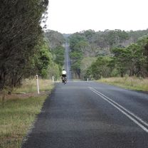
Armidale, Toms Gully, Puddledock loop
Trasa rowerowa rozpoczynająca się w Armidale, Nowa Południowa Walia, Australia.
Przegląd
O tej trasie
Ładna trasa, nieco krótsza niż pełna pętla przez Guyrę. Wyjedź z Armidale pagórkowatą, malowniczą Boorolong Road i skręć w Toms Gully Rd. Ten odcinek jest nieutwardzony na długości ok. 7-8 km. Warto zobaczyć zadbaną stację Black Mountain (brak usług, chyba że ktoś korzysta z budynku i otworzył toalety). Na tę pętlę zabieramy zawsze przekąskę na postój przy stacji, chociaż na stacji przy autostradzie też można kupić jedzenie. Po przecięciu autostrady skręć w lewo, a potem w SpringMount Rd. Ten odcinek również jest częściowo nieutwardzony, ale oferuje świetne widoki. Skręcając w Hoys Rd tuż przed autostradą, można ominąć prawie cały jej odcinek, zanim wrócisz do miasta.
- -:--
- Czas
- 71,6 km
- Dystans
- 607 m
- Przewyższenia
- 607 m
- Spadek
- ---
- Śr. Prędkość
- ---
- Maks. wysokość
Zdjęcia trasy
Kontynuuj z Bikemap
Użyj, edytuj lub pobierz tę trasę rowerową
Chcesz przejechać trasę Armidale, Toms Gully, Puddledock loop lub dostosować ją do swojej wycieczki? Oto, co możesz zrobić z tą trasą na Bikemap:
Darmowe funkcje
- Zapisz tę trasę jako ulubioną lub w kolekcji
- Skopiuj i zaplanuj swoją wersję tej trasy
- Synchronizuj swoją trasę z Garminem lub Wahoo
Funkcje Premium
3 dni bezpłatnej wersji próbnej lub jednorazowa opłata. Dowiedz się więcej o Bikemap Premium.
- Nawiguj po tej trasie na iOS i Androidzie
- Eksportuj plik GPX / KML tej trasy
- Stwórz swój własny wydruk (wypróbuj za darmo)
- Pobierz tę trasę do nawigacji offline
Odkryj więcej funkcji Premium.
Uzyskaj Bikemap PremiumOd naszej społeczności
Armidale: Inne popularne trasy rozpoczynające się tutaj
 New England Cycle Trail South
- Dystans
- 353,4 km
- Przewyższenia
- 999 m
- Spadek
- 1577 m
- Lokalizacja
- Armidale, Nowa Południowa Walia, Australia
 Armidale to Gara river crossing along Herbert Park Rd
- Dystans
- 48,3 km
- Przewyższenia
- 516 m
- Spadek
- 515 m
- Lokalizacja
- Armidale, Nowa Południowa Walia, Australia
 Flat White
- Dystans
- 19,5 km
- Przewyższenia
- 203 m
- Spadek
- 201 m
- Lokalizacja
- Armidale, Nowa Południowa Walia, Australia
 Armidale to Uralla via Arding
- Dystans
- 54,5 km
- Przewyższenia
- 405 m
- Spadek
- 396 m
- Lokalizacja
- Armidale, Nowa Południowa Walia, Australia
 Armidale, Rockvale Rd Chandler Rd loop
- Dystans
- 86,1 km
- Przewyższenia
- 772 m
- Spadek
- 773 m
- Lokalizacja
- Armidale, Nowa Południowa Walia, Australia
 Armidale to Uralla via Hawthorne Dr
- Dystans
- 72,4 km
- Przewyższenia
- 463 m
- Spadek
- 464 m
- Lokalizacja
- Armidale, Nowa Południowa Walia, Australia
 Armidale, Toms Gully, Puddledock loop
- Dystans
- 71,6 km
- Przewyższenia
- 607 m
- Spadek
- 607 m
- Lokalizacja
- Armidale, Nowa Południowa Walia, Australia
 Armidale to Point Lookout loop
- Dystans
- 226,3 km
- Przewyższenia
- 4225 m
- Spadek
- 4225 m
- Lokalizacja
- Armidale, Nowa Południowa Walia, Australia
Otwórz ją w aplikacji


