
Santa Barbara / Montecito foothills loop CLONED FROM ROUTE 552049
Trasa rowerowa rozpoczynająca się w Mission Canyon, Kalifornia, USA.
Przegląd
O tej trasie
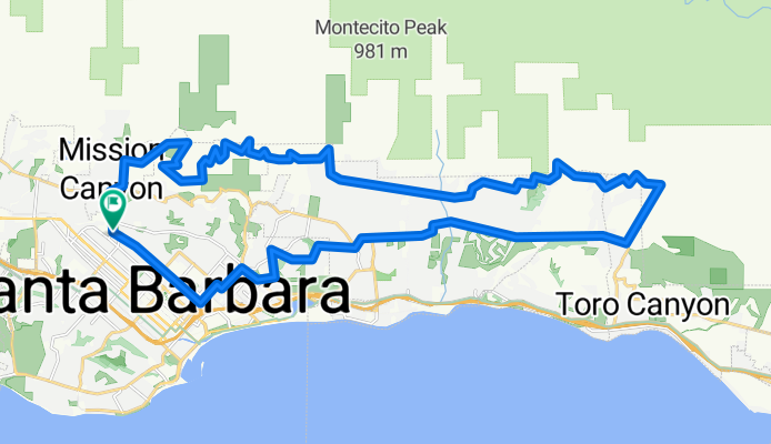
Ta trasa wykorzystuje wszystkie główne utwardzone drogi w okolicach Santa Barbara, które prowadzą wzdłuż podnóża wzgórz. Część pętli przypadająca na podnóża ma niewielki ruch samochodowy, oferuje fantastyczne widoki oraz dobrą różnorodność nachyleń.
Zalecany jest kierunek zgodny z ruchem wskazówek zegara, głównie z powodu wymagającego podjazdu Toro Canyon Rd oraz absurdalnie stromego, chociaż krótkiego, wschodniego początku Viola Ln. Zaplanuj mocną jazdę pod górę Las Canoas Rd do Skofield Park, następnie Park Lane oraz Bella Vista, a na koniec na kilku stromych odcinkach Viola Ln. Reszta jest umiarkowana.
Kilka ostrzeżeń: (1) Pomimo tego, co pokazuje Google Maps, East Mountain Dr kończy się krótko po San Ysidro Ln, ponieważ została zablokowana przez prywatny ośrodek San Ysidro Ranch. Możliwe jest jednak przejechanie przez ośrodek rowerem – wystarczy podążać kamienną podjazdem. (2) Prywatna Viola Lane nie jest dobrze oznaczona na obu końcach. Szukaj grupy czarnych skrzynek pocztowych niedługo po tym, jak kręta Bella Vista Drive staje się prostą Ladera Lane.
- -:--
- Czas
- 42,4 km
- Dystans
- 715 m
- Przewyższenia
- 715 m
- Spadek
- ---
- Śr. Prędkość
- ---
- Maks. wysokość
Kontynuuj z Bikemap
Użyj, edytuj lub pobierz tę trasę rowerową
Chcesz przejechać trasę Santa Barbara / Montecito foothills loop CLONED FROM ROUTE 552049 lub dostosować ją do swojej wycieczki? Oto, co możesz zrobić z tą trasą na Bikemap:
Darmowe funkcje
- Zapisz tę trasę jako ulubioną lub w kolekcji
- Skopiuj i zaplanuj swoją wersję tej trasy
- Synchronizuj swoją trasę z Garminem lub Wahoo
Funkcje Premium
3 dni bezpłatnej wersji próbnej lub jednorazowa opłata. Dowiedz się więcej o Bikemap Premium.
- Nawiguj po tej trasie na iOS i Androidzie
- Eksportuj plik GPX / KML tej trasy
- Stwórz swój własny wydruk (wypróbuj za darmo)
- Pobierz tę trasę do nawigacji offline
Odkryj więcej funkcji Premium.
Uzyskaj Bikemap PremiumOd naszej społeczności
Mission Canyon: Inne popularne trasy rozpoczynające się tutaj
 Santa Barbara Thirty
- Dystans
- 48,5 km
- Przewyższenia
- 423 m
- Spadek
- 423 m
- Lokalizacja
- Mission Canyon, Kalifornia, USA
 Santa Barbara / Montecito foothills loop CLONED FROM ROUTE 552049
- Dystans
- 42,4 km
- Przewyższenia
- 715 m
- Spadek
- 715 m
- Lokalizacja
- Mission Canyon, Kalifornia, USA
 5/28/23 late afternoon bikey
- Dystans
- 20,8 km
- Przewyższenia
- 199 m
- Spadek
- 190 m
- Lokalizacja
- Mission Canyon, Kalifornia, USA
 Santa Barbara Big 32 miles
- Dystans
- 52,2 km
- Przewyższenia
- 694 m
- Spadek
- 700 m
- Lokalizacja
- Mission Canyon, Kalifornia, USA
 4100–4136 Lago Dr, Santa Barbara to 2201 Laguna St, Santa Barbara
- Dystans
- 7 km
- Przewyższenia
- 97 m
- Spadek
- 55 m
- Lokalizacja
- Mission Canyon, Kalifornia, USA
 Santa Barbara Ridge Route
- Dystans
- 46,7 km
- Przewyższenia
- 1325 m
- Spadek
- 1317 m
- Lokalizacja
- Mission Canyon, Kalifornia, USA
 Elings Park Loop
- Dystans
- 16,6 km
- Przewyższenia
- 218 m
- Spadek
- 219 m
- Lokalizacja
- Mission Canyon, Kalifornia, USA
 Gibraltar
- Dystans
- 8,6 km
- Przewyższenia
- 86 m
- Spadek
- 524 m
- Lokalizacja
- Mission Canyon, Kalifornia, USA
Otwórz ją w aplikacji