

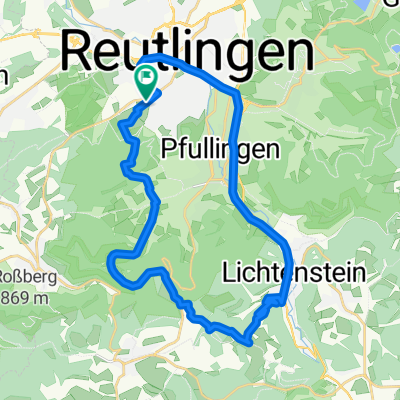
Reutlingen - Pfullinger Berg - Genkingen
Trasa rowerowa rozpoczynająca się w Reutlingen, Badenia-Wirtembergia, Niemcy.
Przegląd
O tej trasie
Podejście na Alb prawie bez samochodów, przez Ochsensteige + Gielsberg
- -:--
- Czas
- 16,5 km
- Dystans
- 541 m
- Przewyższenia
- 142 m
- Spadek
- ---
- Śr. Prędkość
- ---
- Maks. wysokość

Najważniejsze punkty trasy
Punkty zainteresowania na trasie
Interesujące miejsce po 0 km
Interesujące miejsce po 0 km
Reutlingen-Hauptbahnhof
Woda pitna po 0,1 km
TransVelo
Interesujące miejsce po 0,1 km
Reutlingen-Marktplatz
Interesujące miejsce po 0,7 km
Wasserhahn Carport Lerchenstr. 40
Interesujące miejsce po 9,3 km
Ochsensteige
Interesujące miejsce po 9,5 km
NSG Pfullinger Berg
Interesujące miejsce po 11,8 km
Aussichtspunkt
Interesujące miejsce po 12,2 km
Gielsberg
Interesujące miejsce po 13,8 km
Nebelhöhle
Interesujące miejsce po 14,6 km
Schartberg Pfullinger Hütte
Interesujące miejsce po 16,5 km
Genkingen-Rathaus
Kontynuuj z Bikemap
Użyj, edytuj lub pobierz tę trasę rowerową
Chcesz przejechać trasę Reutlingen - Pfullinger Berg - Genkingen lub dostosować ją do swojej wycieczki? Oto, co możesz zrobić z tą trasą na Bikemap:
Darmowe funkcje
- Zapisz tę trasę jako ulubioną lub w kolekcji
- Skopiuj i zaplanuj swoją wersję tej trasy
- Synchronizuj swoją trasę z Garminem lub Wahoo
Funkcje Premium
3 dni bezpłatnej wersji próbnej lub jednorazowa opłata. Dowiedz się więcej o Bikemap Premium.
- Nawiguj po tej trasie na iOS i Androidzie
- Eksportuj plik GPX / KML tej trasy
- Stwórz swój własny wydruk (wypróbuj za darmo)
- Pobierz tę trasę do nawigacji offline
Odkryj więcej funkcji Premium.
Uzyskaj Bikemap PremiumOd naszej społeczności
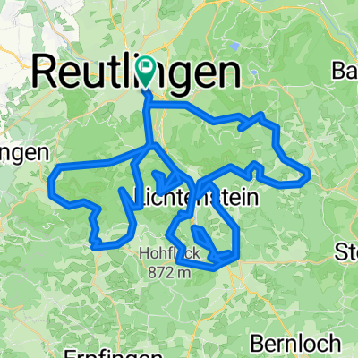
Reutlingen: Inne popularne trasy rozpoczynające się tutaj
 Reutlingen - Lindenhof - Holzelfingen - Reutlingen
- Dystans
- 32,2 km
- Przewyższenia
- 408 m
- Spadek
- 408 m
- Lokalizacja
- Reutlingen, Badenia-Wirtembergia, Niemcy
 Reutlingen-Nebelhöhle
- Dystans
- 29,1 km
- Przewyższenia
- 534 m
- Spadek
- 534 m
- Lokalizacja
- Reutlingen, Badenia-Wirtembergia, Niemcy
 Albtour
- Dystans
- 107,2 km
- Przewyższenia
- 947 m
- Spadek
- 950 m
- Lokalizacja
- Reutlingen, Badenia-Wirtembergia, Niemcy
 Reutlingen Nürtingen Wendlingen 32km 110hm
- Dystans
- 32,4 km
- Przewyższenia
- 90 m
- Spadek
- 217 m
- Lokalizacja
- Reutlingen, Badenia-Wirtembergia, Niemcy
 Reutlinger Alb - Rauf und runter
- Dystans
- 84,1 km
- Przewyższenia
- 2082 m
- Spadek
- 1861 m
- Lokalizacja
- Reutlingen, Badenia-Wirtembergia, Niemcy
 Lautertal
- Dystans
- 75,8 km
- Przewyższenia
- 952 m
- Spadek
- 945 m
- Lokalizacja
- Reutlingen, Badenia-Wirtembergia, Niemcy
 Reutlingen - Südrunde über Stuhlsteige
- Dystans
- 63,5 km
- Przewyższenia
- 578 m
- Spadek
- 578 m
- Lokalizacja
- Reutlingen, Badenia-Wirtembergia, Niemcy
 Eninger Weide
- Dystans
- 15,8 km
- Przewyższenia
- 414 m
- Spadek
- 26 m
- Lokalizacja
- Reutlingen, Badenia-Wirtembergia, Niemcy
Otwórz ją w aplikacji