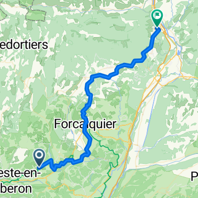
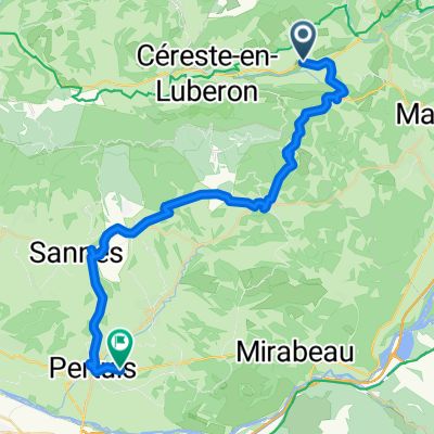
Trasa C – kaňonem Oppedette do Manosque
Trasa rowerowa rozpoczynająca się w Reillanne, Prowansja-Alpy-Lazurowe Wybrzeże, Francja.
Przegląd
O tej trasie
<span style="color: rgb(0, 0, 0); font-family: arial, helvetica, sans-serif; font-size: 13px; font-style: normal; font-variant: normal; font-weight: normal; letter-spacing: normal; line-height: normal; orphans: auto; text-align: -webkit-left; text-indent: 0px; text-transform: none; white-space: normal; widows: auto; word-spacing: 0px; -webkit-text-size-adjust: auto; -webkit-text-stroke-width: 0px; background-color: rgb(255, 255, 255); display: inline !important; float: none;">Vyjedeme od rotundy v půvabné městečkovesničce Simiane-la-Rotonde a po zastávce u opatství<span class="Apple-converted-space"> </span></span><br style="color: rgb(0, 0, 0); font-family: arial, helvetica, sans-serif; font-size: 13px; font-style: normal; font-variant: normal; font-weight: normal; letter-spacing: normal; line-height: normal; orphans: auto; text-align: -webkit-left; text-indent: 0px; text-transform: none; white-space: normal; widows: auto; word-spacing: 0px; -webkit-text-size-adjust: auto; -webkit-text-stroke-width: 0px; background-color: rgb(255, 255, 255);" /> <span style="color: rgb(0, 0, 0); font-family: arial, helvetica, sans-serif; font-size: 13px; font-style: normal; font-variant: normal; font-weight: normal; letter-spacing: normal; line-height: normal; orphans: auto; text-align: -webkit-left; text-indent: 0px; text-transform: none; white-space: normal; widows: auto; word-spacing: 0px; -webkit-text-size-adjust: auto; -webkit-text-stroke-width: 0px; background-color: rgb(255, 255, 255); display: inline !important; float: none;">Valsaites pojedeme kolem jednoho z nejstrmějších kaňonů v Provence – kaňonu d´Oppedette.<span class="Apple-converted-space"> </span></span><br style="color: rgb(0, 0, 0); font-family: arial, helvetica, sans-serif; font-size: 13px; font-style: normal; font-variant: normal; font-weight: normal; letter-spacing: normal; line-height: normal; orphans: auto; text-align: -webkit-left; text-indent: 0px; text-transform: none; white-space: normal; widows: auto; word-spacing: 0px; -webkit-text-size-adjust: auto; -webkit-text-stroke-width: 0px; background-color: rgb(255, 255, 255);" /> <span style="color: rgb(0, 0, 0); font-family: arial, helvetica, sans-serif; font-size: 13px; font-style: normal; font-variant: normal; font-weight: normal; letter-spacing: normal; line-height: normal; orphans: auto; text-align: -webkit-left; text-indent: 0px; text-transform: none; white-space: normal; widows: auto; word-spacing: 0px; -webkit-text-size-adjust: auto; -webkit-text-stroke-width: 0px; background-color: rgb(255, 255, 255); display: inline !important; float: none;">Prohlédneme si městečkovesničku Viens postavenou na skalnatém ostrohu a poté starý převorský<span class="Apple-converted-space"> </span></span><br style="color: rgb(0, 0, 0); font-family: arial, helvetica, sans-serif; font-size: 13px; font-style: normal; font-variant: normal; font-weight: normal; letter-spacing: normal; line-height: normal; orphans: auto; text-align: -webkit-left; text-indent: 0px; text-transform: none; white-space: normal; widows: auto; word-spacing: 0px; -webkit-text-size-adjust: auto; -webkit-text-stroke-width: 0px; background-color: rgb(255, 255, 255);" /> <span style="color: rgb(0, 0, 0); font-family: arial, helvetica, sans-serif; font-size: 13px; font-style: normal; font-variant: normal; font-weight: normal; letter-spacing: normal; line-height: normal; orphans: auto; text-align: -webkit-left; text-indent: 0px; text-transform: none; white-space: normal; widows: auto; word-spacing: 0px; -webkit-text-size-adjust: auto; -webkit-text-stroke-width: 0px; background-color: rgb(255, 255, 255); display: inline !important; float: none;">kostel Prieuré de Carluc. Z městečkovesničky Cereste se vydáme zvolna podél úpatí velkého Luberonu do Montfuronu, kde se vypíná zachovalý větrný mlýn, nedaleko od něj je pak kaple StElzeard. Poté sjedeme do Manosque, města již u nás známé přírodní kosmetiky L´Occitanne. Zde si kromě historické části města prohlédneme město také z výšky z věže na Mont d´Or na jednom z pahorků nedaleko centra.</span>
- -:--
- Czas
- 53,4 km
- Dystans
- 886 m
- Przewyższenia
- 1226 m
- Spadek
- ---
- Śr. Prędkość
- ---
- Maks. wysokość
Jakość trasy
Typy dróg i nawierzchnie na trasie
Typy dróg
Spokojna droga
20,9 km
(39 %)
Droga
16,6 km
(31 %)
Powierzchnie
Utwardzona
26,1 km
(49 %)
Nieutwardzona
5,4 km
(10 %)
Asfalt
26 km
(49 %)
Żwir
4,1 km
(8 %)
Kontynuuj z Bikemap
Użyj, edytuj lub pobierz tę trasę rowerową
Chcesz przejechać trasę Trasa C – kaňonem Oppedette do Manosque lub dostosować ją do swojej wycieczki? Oto, co możesz zrobić z tą trasą na Bikemap:
Darmowe funkcje
- Zapisz tę trasę jako ulubioną lub w kolekcji
- Skopiuj i zaplanuj swoją wersję tej trasy
- Synchronizuj swoją trasę z Garminem lub Wahoo
Funkcje Premium
3 dni bezpłatnej wersji próbnej lub jednorazowa opłata. Dowiedz się więcej o Bikemap Premium.
- Nawiguj po tej trasie na iOS i Androidzie
- Eksportuj plik GPX / KML tej trasy
- Stwórz swój własny wydruk (wypróbuj za darmo)
- Pobierz tę trasę do nawigacji offline
Odkryj więcej funkcji Premium.
Uzyskaj Bikemap PremiumOd naszej społeczności
Reillanne: Inne popularne trasy rozpoczynające się tutaj
- Haut >Luberon Mai 2021
- Dystans
- 108,1 km
- Przewyższenia
- 1363 m
- Spadek
- 1364 m
- Lokalizacja
- Reillanne, Prowansja-Alpy-Lazurowe Wybrzeże, Francja
- 24-16a Reillanne - Mirabeau
- Dystans
- 40,4 km
- Przewyższenia
- 694 m
- Spadek
- 871 m
- Lokalizacja
- Reillanne, Prowansja-Alpy-Lazurowe Wybrzeże, Francja
- De La Place 63, Vachères à Place Pierre Puget 79, La Londe-les-Maures
- Dystans
- 140,4 km
- Przewyższenia
- 967 m
- Spadek
- 1836 m
- Lokalizacja
- Reillanne, Prowansja-Alpy-Lazurowe Wybrzeże, Francja
- St Martin
- Dystans
- 45,4 km
- Przewyższenia
- 746 m
- Spadek
- 698 m
- Lokalizacja
- Reillanne, Prowansja-Alpy-Lazurowe Wybrzeże, Francja
- Simiane-La-Rotonde - Rustrel - Oppedete - Manosque
- Dystans
- 73,3 km
- Przewyższenia
- 1009 m
- Spadek
- 1312 m
- Lokalizacja
- Reillanne, Prowansja-Alpy-Lazurowe Wybrzeże, Francja
- 13 March 53km Villemus (Saint-Martin-les-Eaux) – Saint-Paul-lez-Durance
- Dystans
- 53,5 km
- Przewyższenia
- 144 m
- Spadek
- 408 m
- Lokalizacja
- Reillanne, Prowansja-Alpy-Lazurowe Wybrzeże, Francja
- 24-16b Reillanne - Mirabeau
- Dystans
- 74 km
- Przewyższenia
- 699 m
- Spadek
- 879 m
- Lokalizacja
- Reillanne, Prowansja-Alpy-Lazurowe Wybrzeże, Francja
- Trasa C – kaňonem Oppedette do Manosque
- Dystans
- 53,4 km
- Przewyższenia
- 886 m
- Spadek
- 1226 m
- Lokalizacja
- Reillanne, Prowansja-Alpy-Lazurowe Wybrzeże, Francja
Otwórz ją w aplikacji