

The Ladywell Way - Motherwell to Forth Road Bridge
Trasa rowerowa rozpoczynająca się w Motherwell, Szkocja, Zjednoczone Królestwo Wielkiej Brytanii.
Przegląd
O tej trasie
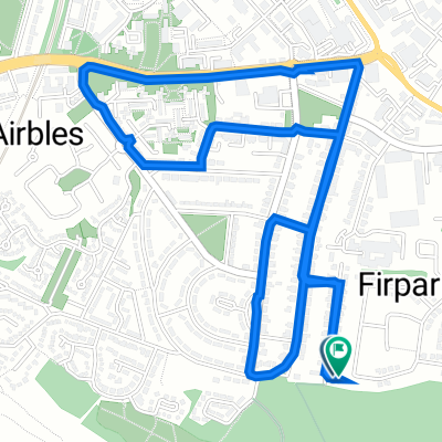
Great pilgrimage route from Motherwell to Forth Road Bridge and then on to St Andrews About 60 kilometres starting with quiet roads leading from Mothewell town centre and then out into the countryside onto bleak moorland paths, river tracks, and canals footpaths. Historic gems like William Wallace's cave, Abercorn church and Hopetoun House along the way. For detailed route descriptions see The Ladywell Way - Motherwell to Hillend The Ladywell Way - Hillend to Avonbridge The Ladywell Way – Avonbridge to Linlithgow The Ladywell Way - Linlithgow to Forth Road Bridge Part of The Way of St Andrews - For other routes see http://www.thewayofstandrews.com
- -:--
- Czas
- 57,1 km
- Dystans
- 312 m
- Przewyższenia
- 371 m
- Spadek
- ---
- Śr. Prędkość
- ---
- Maks. wysokość

Najważniejsze punkty trasy
Punkty zainteresowania na trasie

Interesujące miejsce po 2,8 km
Carfin Grotto. This shrine, in emulation of the famous grotto at Lourdes, was started in the 1920s and built by local parishioners and coal miners out of work during the 1921 Coal Miners' Strike. The parish priest felt the need to keep these workers occupied to minimise the effects of unemployment on their morale.

Interesujące miejsce po 27,7 km
Joins River Avon Heritage Trail
Interesujące miejsce po 34,1 km
Leaves Avon Heritage Trail

Interesujące miejsce po 40 km
Union Canal. This canal, running from Falkirk to Edinburgh, was constructed in the early nineteenth century to bring minerals, especially coal, to Edinburgh
Kontynuuj z Bikemap
Użyj, edytuj lub pobierz tę trasę rowerową
Chcesz przejechać trasę The Ladywell Way - Motherwell to Forth Road Bridge lub dostosować ją do swojej wycieczki? Oto, co możesz zrobić z tą trasą na Bikemap:
Darmowe funkcje
- Zapisz tę trasę jako ulubioną lub w kolekcji
- Skopiuj i zaplanuj swoją wersję tej trasy
- Synchronizuj swoją trasę z Garminem lub Wahoo
Funkcje Premium
3 dni bezpłatnej wersji próbnej lub jednorazowa opłata. Dowiedz się więcej o Bikemap Premium.
- Nawiguj po tej trasie na iOS i Androidzie
- Eksportuj plik GPX / KML tej trasy
- Stwórz swój własny wydruk (wypróbuj za darmo)
- Pobierz tę trasę do nawigacji offline
Odkryj więcej funkcji Premium.
Uzyskaj Bikemap PremiumOd naszej społeczności
Motherwell: Inne popularne trasy rozpoczynające się tutaj
 The Ladywell Way - Motherwell to Hillend Reservoir
- Dystans
- 33 km
- Przewyższenia
- 340 m
- Spadek
- 339 m
- Lokalizacja
- Motherwell, Szkocja, Zjednoczone Królestwo Wielkiej Brytanii
 The Ladywell Way - Motherwell to Hillend Reservoir
- Dystans
- 17,3 km
- Przewyższenia
- 268 m
- Spadek
- 147 m
- Lokalizacja
- Motherwell, Szkocja, Zjednoczone Królestwo Wielkiej Brytanii
 Watling Street
- Dystans
- 13,1 km
- Przewyższenia
- 104 m
- Spadek
- 104 m
- Lokalizacja
- Motherwell, Szkocja, Zjednoczone Królestwo Wielkiej Brytanii
 North-Holytown-The Craig- Strathy-Home
- Dystans
- 21,2 km
- Przewyższenia
- 151 m
- Spadek
- 151 m
- Lokalizacja
- Motherwell, Szkocja, Zjednoczone Królestwo Wielkiej Brytanii
 Home loop via barronshaugh
- Dystans
- 10,9 km
- Przewyższenia
- 104 m
- Spadek
- 103 m
- Lokalizacja
- Motherwell, Szkocja, Zjednoczone Królestwo Wielkiej Brytanii
 Woodlands Road 31 to Woodlands Road 31
- Dystans
- 14,2 km
- Przewyższenia
- 102 m
- Spadek
- 148 m
- Lokalizacja
- Motherwell, Szkocja, Zjednoczone Królestwo Wielkiej Brytanii
 Woodlands Road 31 to Woodlands Road 29
- Dystans
- 4,1 km
- Przewyższenia
- 34 m
- Spadek
- 81 m
- Lokalizacja
- Motherwell, Szkocja, Zjednoczone Królestwo Wielkiej Brytanii
 Watson Street 250 to Sauchiehall Street 2
- Dystans
- 24,3 km
- Przewyższenia
- 186 m
- Spadek
- 223 m
- Lokalizacja
- Motherwell, Szkocja, Zjednoczone Królestwo Wielkiej Brytanii
Otwórz ją w aplikacji