

Doi Pui To Ban Pong
Trasa rowerowa rozpoczynająca się w Cziang Maj, Prowincja Chiang Mai, Tajlandia.
Przegląd
O tej trasie
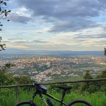
This is a fairly long cross country ride on the less travelled southern side of the Doi Suthep/Pui national park. It begins at Bhubing helipad on Sriwichai Rd., continues through Ban Hmong Doi Pui to the Doi Pha Klong viewpoint and then turns south running through forest, fields, orchards and bamboo groves until it reaches Samoeng Rd. (1269). It continues with an optional loop through the Krisdadoi hills before it returns to Samoeng Rd. From Ban Pong it takes a shortcut through the foothills directly to Ban Huai Sai and then the canal road.
The ride is 80% offroad over forest path, single track trails, fire roads and farm roads. The terrain is partly rough and requires a mountain bike. The total ascent is almost 700m and the total descent is 1700m.- -:--
- Czas
- 41,1 km
- Dystans
- 576 m
- Przewyższenia
- 1659 m
- Spadek
- ---
- Śr. Prędkość
- ---
- Maks. wysokość

Jakość trasy
Typy dróg i nawierzchnie na trasie
Typy dróg
Droga leśna
18,2 km
(44 %)
Spokojna droga
11,1 km
(27 %)
Powierzchnie
Utwardzona
14,1 km
(34 %)
Nieutwardzona
26,2 km
(64 %)
Nieutwardzony (nieokreślony)
21,7 km
(53 %)
Asfalt
8,8 km
(21 %)
Kontynuuj z Bikemap
Użyj, edytuj lub pobierz tę trasę rowerową
Chcesz przejechać trasę Doi Pui To Ban Pong lub dostosować ją do swojej wycieczki? Oto, co możesz zrobić z tą trasą na Bikemap:
Darmowe funkcje
- Zapisz tę trasę jako ulubioną lub w kolekcji
- Skopiuj i zaplanuj swoją wersję tej trasy
- Synchronizuj swoją trasę z Garminem lub Wahoo
Funkcje Premium
3 dni bezpłatnej wersji próbnej lub jednorazowa opłata. Dowiedz się więcej o Bikemap Premium.
- Nawiguj po tej trasie na iOS i Androidzie
- Eksportuj plik GPX / KML tej trasy
- Stwórz swój własny wydruk (wypróbuj za darmo)
- Pobierz tę trasę do nawigacji offline
Odkryj więcej funkcji Premium.
Uzyskaj Bikemap PremiumOd naszej społeczności
Cziang Maj: Inne popularne trasy rozpoczynające się tutaj
 Moderate Route in Chiang Mai
- Dystans
- 7,4 km
- Przewyższenia
- 21 m
- Spadek
- 18 m
- Lokalizacja
- Cziang Maj, Prowincja Chiang Mai, Tajlandia
 Phuping Palace
- Dystans
- 52,2 km
- Przewyższenia
- 1083 m
- Spadek
- 1098 m
- Lokalizacja
- Cziang Maj, Prowincja Chiang Mai, Tajlandia
 CPB small circle
- Dystans
- 13,7 km
- Przewyższenia
- 73 m
- Spadek
- 71 m
- Lokalizacja
- Cziang Maj, Prowincja Chiang Mai, Tajlandia
 MHS Loop
- Dystans
- 533,7 km
- Przewyższenia
- 5294 m
- Spadek
- 5289 m
- Lokalizacja
- Cziang Maj, Prowincja Chiang Mai, Tajlandia
 Chiangmai U to Doi Su Thep view point
- Dystans
- 18,1 km
- Przewyższenia
- 404 m
- Spadek
- 403 m
- Lokalizacja
- Cziang Maj, Prowincja Chiang Mai, Tajlandia
 Chiang Mai - Rim Ping
- Dystans
- 65 km
- Przewyższenia
- 30 m
- Spadek
- 29 m
- Lokalizacja
- Cziang Maj, Prowincja Chiang Mai, Tajlandia
 DoiSuthep
- Dystans
- 49,9 km
- Przewyższenia
- 1107 m
- Spadek
- 1109 m
- Lokalizacja
- Cziang Maj, Prowincja Chiang Mai, Tajlandia
 Cycle in Thai 03 : Chiang Rai, Myanmar
- Dystans
- 263,6 km
- Przewyższenia
- 781 m
- Spadek
- 703 m
- Lokalizacja
- Cziang Maj, Prowincja Chiang Mai, Tajlandia
Otwórz ją w aplikacji