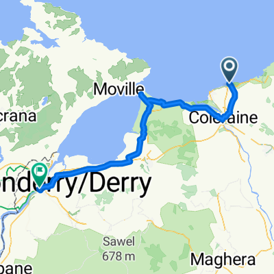
Portrush - Mussenden Temple (23.87m/38.42km)
Trasa rowerowa rozpoczynająca się w Portrush, Irlandia Północna, Zjednoczone Królestwo Wielkiej Brytanii.
Przegląd
O tej trasie
Rozpoczynając w Portrush, kierujemy się na południe główną drogą do uniwersyteckiego miasta Coleraine, zanim skierujemy się na zachód przez rzekę Bann do kaprysu Mussenden Temple. Następnie na krótką chwilę wjeżdżamy do lasu Downhill, zanim odbijemy na wschód i zrobimy objazd do odsłoniętej wioski Castlerock, po czym wracamy przez rzekę i Coleraine. Na tej trasie jest tak wiele do zobaczenia i wiele okazji, by zsiąść z roweru i zwiedzać, czy to w Coleraine, przy Mussenden Temple, w lesie Downhill czy w Castlerock.
- -:--
- Czas
- 38,5 km
- Dystans
- 216 m
- Przewyższenia
- 214 m
- Spadek
- ---
- Śr. Prędkość
- ---
- Maks. wysokość
Jakość trasy
Typy dróg i nawierzchnie na trasie
Typy dróg
Spokojna droga
8,8 km
(23 %)
Strefa dla pieszych
3,8 km
(10 %)
Powierzchnie
Utwardzona
29,2 km
(76 %)
Asfalt
29,2 km
(76 %)
Niezdefiniowany
9,2 km
(24 %)
Kontynuuj z Bikemap
Użyj, edytuj lub pobierz tę trasę rowerową
Chcesz przejechać trasę Portrush - Mussenden Temple (23.87m/38.42km) lub dostosować ją do swojej wycieczki? Oto, co możesz zrobić z tą trasą na Bikemap:
Darmowe funkcje
- Zapisz tę trasę jako ulubioną lub w kolekcji
- Skopiuj i zaplanuj swoją wersję tej trasy
- Synchronizuj swoją trasę z Garminem lub Wahoo
Funkcje Premium
3 dni bezpłatnej wersji próbnej lub jednorazowa opłata. Dowiedz się więcej o Bikemap Premium.
- Nawiguj po tej trasie na iOS i Androidzie
- Eksportuj plik GPX / KML tej trasy
- Stwórz swój własny wydruk (wypróbuj za darmo)
- Pobierz tę trasę do nawigacji offline
Odkryj więcej funkcji Premium.
Uzyskaj Bikemap PremiumOd naszej społeczności
Portrush: Inne popularne trasy rozpoczynające się tutaj
 Tag 45: Giant's Causeway/Überfahrt Schottland
- Dystans
- 35,4 km
- Przewyższenia
- 508 m
- Spadek
- 589 m
- Lokalizacja
- Portrush, Irlandia Północna, Zjednoczone Królestwo Wielkiej Brytanii
 Strand Road 2 do Castlehill Way 8
- Dystans
- 27,6 km
- Przewyższenia
- 133 m
- Spadek
- 85 m
- Lokalizacja
- Portrush, Irlandia Północna, Zjednoczone Królestwo Wielkiej Brytanii
 29 West Strand Ave, Portrush to 2 Inishowen Crescent, Portstewart
- Dystans
- 6,5 km
- Przewyższenia
- 62 m
- Spadek
- 35 m
- Lokalizacja
- Portrush, Irlandia Północna, Zjednoczone Królestwo Wielkiej Brytanii
 5 giorno
- Dystans
- 74,8 km
- Przewyższenia
- 417 m
- Spadek
- 423 m
- Lokalizacja
- Portrush, Irlandia Północna, Zjednoczone Królestwo Wielkiej Brytanii
 Portrush - Mussenden Temple (23.87m/38.42km)
- Dystans
- 38,5 km
- Przewyższenia
- 216 m
- Spadek
- 214 m
- Lokalizacja
- Portrush, Irlandia Północna, Zjednoczone Królestwo Wielkiej Brytanii
 Day 15_ Portrush - Bushmills
- Dystans
- 19,7 km
- Przewyższenia
- 248 m
- Spadek
- 248 m
- Lokalizacja
- Portrush, Irlandia Północna, Zjednoczone Królestwo Wielkiej Brytanii
 Portrush - Castlerock
- Dystans
- 20,1 km
- Przewyższenia
- 151 m
- Spadek
- 159 m
- Lokalizacja
- Portrush, Irlandia Północna, Zjednoczone Królestwo Wielkiej Brytanii
 Portrush - Magilligan Point (45.46m/73.17km)
- Dystans
- 73,3 km
- Przewyższenia
- 508 m
- Spadek
- 508 m
- Lokalizacja
- Portrush, Irlandia Północna, Zjednoczone Królestwo Wielkiej Brytanii
Otwórz ją w aplikacji

