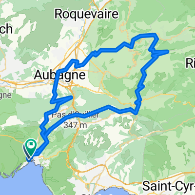
Cassis - Barjols
Trasa rowerowa rozpoczynająca się w Cassis, Prowansja-Alpy-Lazurowe Wybrzeże, Francja.
Przegląd
O tej trasie
2.Etappe meiner Frankreich-Reise '08:
<table style="border-collapse: collapse; width: 98pt;" border="0" cellspacing="0" cellpadding="0" width="131"> <tbody> <tr style="height: 12.75pt;" height="17"> <td class="xl24" style="height: 12.75pt; width: 98pt;" width="131" height="17">
Cassis
</td> </tr> </tbody> </table>
<table style="border-collapse: collapse; width: 98pt;" border="0" cellspacing="0" cellpadding="0" width="131"> <tbody> <tr style="height: 12.75pt;" height="17"> <td class="xl25" style="height: 12.75pt;" height="17">
Mont de la Saoupe
</td> </tr> </tbody> </table> <table style="border-collapse: collapse; width: 98pt;" border="0" cellspacing="0" cellpadding="0" width="131"> <tbody> <tr style="height: 12.75pt;" height="17"> <td class="xl25" style="height: 12.75pt;" height="17">
Grde de Tête
</td> </tr> </tbody> </table> <table style="border-collapse: collapse; width: 98pt;" border="0" cellspacing="0" cellpadding="0" width="131"> <tbody> <tr style="height: 12.75pt;" height="17"> <td class="xl24" style="height: 12.75pt;" height="17">
La Ciotat
</td> </tr> </tbody> </table> <table style="border-collapse: collapse; width: 98pt;" border="0" cellspacing="0" cellpadding="0" width="131"> <tbody> <tr style="height: 12.75pt;" height="17"> <td class="xl24" style="height: 12.75pt;" height="17">
Ceyreste
</td> </tr> </tbody> </table> <table style="border-collapse: collapse; width: 98pt;" border="0" cellspacing="0" cellpadding="0" width="131"> <tbody> <tr style="height: 12.75pt;" height="17"> <td class="xl24" style="height: 12.75pt;" height="17">
Mauregard
</td> </tr> </tbody> </table> <table style="border-collapse: collapse; width: 98pt;" border="0" cellspacing="0" cellpadding="0" width="131"> <tbody> <tr style="height: 12.75pt;" height="17"> <td class="xl24" style="height: 12.75pt;" height="17">
Le Grd Caunet
</td> </tr> </tbody> </table> <table style="border-collapse: collapse; width: 98pt;" border="0" cellspacing="0" cellpadding="0" width="131"> <tbody> <tr style="height: 12.75pt;" height="17"> <td class="xl24" style="height: 12.75pt;" height="17">
Richtung Pinval / Gemenos
</td> </tr> </tbody> </table> <table style="border-collapse: collapse; width: 98pt;" border="0" cellspacing="0" cellpadding="0" width="131"> <tbody> <tr style="height: 12.75pt;" height="17"> <td class="xl24" style="height: 12.75pt;" height="17">
Gemenos
</td> </tr> </tbody> </table>
<table style="border-collapse: collapse; width: 98pt;" border="0" cellspacing="0" cellpadding="0" width="131"> <tbody> <tr style="height: 12.75pt;" height="17"> <td class="xl24" style="height: 12.75pt;" height="17"></td> </tr> </tbody> </table>
<table style="border-collapse: collapse; width: 98pt;" border="0" cellspacing="0" cellpadding="0" width="131"> <tbody> <tr style="height: 12.75pt;" height="17"> <td class="xl25" style="height: 12.75pt;" height="17">
Col d'Espigoulier
</td> </tr> </tbody> </table> <table style="border-collapse: collapse; width: 98pt;" border="0" cellspacing="0" cellpadding="0" width="131"> <tbody> <tr style="height: 12.75pt;" height="17"> <td class="xl24" style="height: 12.75pt;" height="17">
Plan-D'Aups
</td> </tr> </tbody> </table> <table style="border-collapse: collapse; width: 98pt;" border="0" cellspacing="0" cellpadding="0" width="131"> <tbody> <tr style="height: 12.75pt;" height="17"> <td class="xl24" style="height: 12.75pt;" height="17">
Mazaugues
</td> </tr> </tbody> </table> <table style="border-collapse: collapse; width: 98pt;" border="0" cellspacing="0" cellpadding="0" width="131"> <tbody> <tr style="height: 12.75pt;" height="17"> <td class="xl24" style="height: 12.75pt;" height="17"></td> </tr> </tbody> </table> <table style="border-collapse: collapse; width: 98pt;" border="0" cellspacing="0" cellpadding="0" width="131"> <tbody> <tr style="height: 12.75pt;" height="17"> <td class="xl24" style="height: 12.75pt;" height="17">
Les Censiés
</td> </tr> </tbody> </table> <table style="border-collapse: collapse; width: 98pt;" border="0" cellspacing="0" cellpadding="0" width="131"> <tbody> <tr style="height: 12.75pt;" height="17"> <td class="xl24" style="height: 12.75pt;" height="17">
Bras
</td> </tr> </tbody> </table> <table style="border-collapse: collapse; width: 98pt;" border="0" cellspacing="0" cellpadding="0" width="131"> <tbody> <tr style="height: 13.5pt;" height="18"> <td class="xl24" style="height: 13.5pt;" height="18">
Saint Estève
</td> </tr> </tbody> </table> <table style="border-collapse: collapse; width: 98pt;" border="0" cellspacing="0" cellpadding="0" width="131"> <tbody> <tr style="height: 12.75pt;" height="17"> <td class="xl24" style="height: 12.75pt;" height="17">
Brue Auriac
</td> </tr> </tbody> </table> <table style="border-collapse: collapse; width: 98pt;" border="0" cellspacing="0" cellpadding="0" width="131"> <tbody> <tr style="height: 12.75pt;" height="17"> <td class="xl24" style="height: 12.75pt;" height="17">
Barjols
</td> </tr> </tbody> </table>
<br />
<table style="border-collapse: collapse; width: 98pt;" border="0" cellspacing="0" cellpadding="0" width="131"> <tbody> </tbody> </table>
- -:--
- Czas
- 116,9 km
- Dystans
- 1705 m
- Przewyższenia
- 1542 m
- Spadek
- ---
- Śr. Prędkość
- ---
- Maks. wysokość
Kontynuuj z Bikemap
Użyj, edytuj lub pobierz tę trasę rowerową
Chcesz przejechać trasę Cassis - Barjols lub dostosować ją do swojej wycieczki? Oto, co możesz zrobić z tą trasą na Bikemap:
Darmowe funkcje
- Zapisz tę trasę jako ulubioną lub w kolekcji
- Skopiuj i zaplanuj swoją wersję tej trasy
- Podziel trasę na etapy, aby utworzyć kilkudniową wycieczkę
- Synchronizuj swoją trasę z Garminem lub Wahoo
Funkcje Premium
3 dni bezpłatnej wersji próbnej lub jednorazowa opłata. Dowiedz się więcej o Bikemap Premium.
- Nawiguj po tej trasie na iOS i Androidzie
- Eksportuj plik GPX / KML tej trasy
- Stwórz swój własny wydruk (wypróbuj za darmo)
- Pobierz tę trasę do nawigacji offline
Odkryj więcej funkcji Premium.
Uzyskaj Bikemap PremiumOd naszej społeczności
Cassis: Inne popularne trasy rozpoczynające się tutaj
- Cassis - Barjols
- Dystans
- 116,9 km
- Przewyższenia
- 1705 m
- Spadek
- 1542 m
- Lokalizacja
- Cassis, Prowansja-Alpy-Lazurowe Wybrzeże, Francja
- Cassis-Col d'Espigoulier
- Dystans
- 79,4 km
- Przewyższenia
- 1082 m
- Spadek
- 1082 m
- Lokalizacja
- Cassis, Prowansja-Alpy-Lazurowe Wybrzeże, Francja
- ride from Cassis to Marseille
- Dystans
- 21,4 km
- Przewyższenia
- 249 m
- Spadek
- 395 m
- Lokalizacja
- Cassis, Prowansja-Alpy-Lazurowe Wybrzeże, Francja
- Provence 2009 - Tappa 07 (proposta)
- Dystans
- 91,7 km
- Przewyższenia
- 929 m
- Spadek
- 931 m
- Lokalizacja
- Cassis, Prowansja-Alpy-Lazurowe Wybrzeże, Francja
- Barcelona 11
- Dystans
- 66 km
- Przewyższenia
- 750 m
- Spadek
- 737 m
- Lokalizacja
- Cassis, Prowansja-Alpy-Lazurowe Wybrzeże, Francja
- 2016J20Soir : Casino de Cassis
- Dystans
- 1,7 km
- Przewyższenia
- 9 m
- Spadek
- 85 m
- Lokalizacja
- Cassis, Prowansja-Alpy-Lazurowe Wybrzeże, Francja
- calanque d’en vau
- Dystans
- 16 km
- Przewyższenia
- 332 m
- Spadek
- 326 m
- Lokalizacja
- Cassis, Prowansja-Alpy-Lazurowe Wybrzeże, Francja
- Cassis - Ciotat 14 km
- Dystans
- 14,8 km
- Przewyższenia
- 560 m
- Spadek
- 573 m
- Lokalizacja
- Cassis, Prowansja-Alpy-Lazurowe Wybrzeże, Francja
Otwórz ją w aplikacji