Annan - Wigton
- 71,6 km
- 1259 m
- 1051 m
- Gretna, Szkocja, Zjednoczone Królestwo Wielkiej Brytanii
Trasa rowerowa rozpoczynająca się w Gretna, Szkocja, Zjednoczone Królestwo Wielkiej Brytanii.
Przegląd
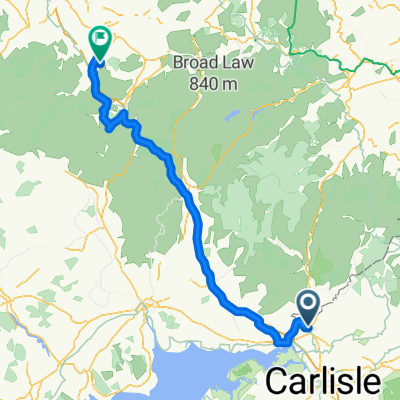
Dzień 7 - Gretna do Irvine Ta trasa prowadzi A713 i jest krótsza niż jazda drogami obok A76. Przydatne informacje: Sklep rowerowy w Ayr był bardzo pomocnym i przyjaznym miejscem. Nie pamiętam, jak się nazywał, ale gdy jedziesz na północ drogą A tuż po moście, gdzie NCR7 ją przecina, jest po lewej stronie drogi. NCR7 prowadzi wzdłuż wybrzeża do Ardrossen. Zrób NCR7 z Ayr, który sięga aż do Troon, a później do Irvine i Ardrossen. (Nie zrobiliśmy tego, ponieważ oznakowanie na ziemi nie dało nam wskazówek, dokąd prowadzi !!) więc wzięliśmy trasę A do Ardrossen. Zakwaterowanie: Nocleg w Irvine. Rach ma to zarezerwować.
utworzono 11 lat temu temu
Jakość trasy
Droga rowerowa
14 km
(9 %)
Spokojna droga
9,3 km
(6 %)
Utwardzona
17,1 km
(11 %)
Asfalt
17,1 km
(11 %)
Niezdefiniowany
138,3 km
(89 %)
Kontynuuj z Bikemap
Chcesz przejechać trasę LeJog_Day 7_Gretna to Irvine via the A713 lub dostosować ją do swojej wycieczki? Oto, co możesz zrobić z tą trasą na Bikemap:
3 dni bezpłatnej wersji próbnej lub jednorazowa opłata. Dowiedz się więcej o Bikemap Premium.
Odkryj więcej funkcji Premium.
Uzyskaj Bikemap PremiumOd naszej społeczności
Otwórz ją w aplikacji